Property Record
S State Highway Ff, Brookline, MO 65619

This Property Is For Sale
Property Detail
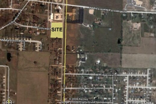
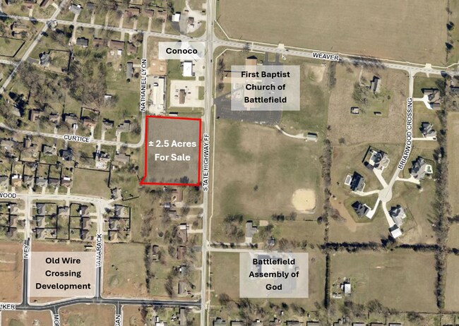
S State Highway Ff
18-19-100-131
BATTLEFIELD IRR 2.50A M/L BEG 39.86 FT W & 249.05 FT S NE CO R NE1/4 19/28/22 S406.48 FT W 329.64 FT NELY 51.15 FT N 365. 15 FT E 299.68 FT TO BEG (EX N 48.51FT) 19/28/22
Commercialacreage
GREENE
INC
Missouri
B and X Area of moderate flood hazard, usually the area between the limits of the 100-year and 500-year floods.
2.50 AC
2025
Outlying Greene County
2025
Springfield
004105
Springfield, MO
NEARBY LISTINGS FOR SALE OR LEASE
DEMOGRAPHICS near S State Highway Ff
1 mile
3 mile
5 mile
2025 Total Population
5,873
30,346
82,812
2030 Population
5,991
30,942
84,769
Pop Growth 2025-2030
+ 2.01%
+ 1.96%
+ 2.36%
Average Age
40
39
40
2025 Total Households
2,231
12,179
34,394
HH Growth 2025-2030
+ 2.02%
+ 2.04%
+ 2.36%
Median Household Inc
$99,266
$76,707
$69,022
Avg Household Size
2.60
2.50
2.30
2025 Avg HH Vehicles
2.00
2.00
2.00
Median Home Value
$263,899
$272,962
$255,332
Median Year Built
2000
1996
1994
Nearby Places
Map Layers
Map Styles
 Street
 Aerial
Transit
 Traffic
 Biking
Places
Listings with unknown addresses are not visible on the map
- Restaurants
- Banks
- Shops
- Fitness
- Groceries
PUBLIC TRANSPORTATION
AIRPORT
Springfield-Branson Ntl
Drive
Walk
Distance
Springfield-Branson Ntl
26 min
12.4 mi
Freight Ports
Tulsa Port of Inola
Drive
Walk
Distance
Tulsa Port of Inola
189 min
170.0 mi
Nearby Properties
Address
Land Use
TOTAL SIZE
Lot Size
Zoning
Address
Land Use
TOTAL SIZE
Lot Size
Zoning
Address
Land Use
TOTAL SIZE
Lot Size
Zoning
6.24 AC
INC
Address
Land Use
TOTAL SIZE
Lot Size
Zoning
8.26 AC
INC
Address
Land Use
TOTAL SIZE
Lot Size
Zoning
Address
Land Use
TOTAL SIZE
Lot Size
Zoning
43,884 SF
2.42 AC
INC
Address
Land Use
TOTAL SIZE
Lot Size
Zoning
126,242 SF
4.75 AC
INC
Address
Land Use
TOTAL SIZE
Lot Size
Zoning
85,030 SF
8.89 AC
INC
Address
Land Use
TOTAL SIZE
Lot Size
Zoning
128,448 SF
4.30 AC
INC
Address
Land Use
TOTAL SIZE
Lot Size
Zoning
5.63 AC
INC
Address
Land Use
TOTAL SIZE
Lot Size
Zoning
6.65 AC
INC
Address
Land Use
TOTAL SIZE
Lot Size
Zoning
132,065 SF
8 AC
INC
Address
Land Use
TOTAL SIZE
Lot Size
Zoning
Address
Land Use
TOTAL SIZE
Lot Size
Zoning
94,344 SF
3.54 AC
INC
Address
Land Use
TOTAL SIZE
Lot Size
Zoning
50,250 SF
4.01 AC
INC
Address
Land Use
TOTAL SIZE
Lot Size
Zoning
80,133 SF
3.16 AC
INC
Address
Land Use
TOTAL SIZE
Lot Size
Zoning
6.36 AC
INC
Address
Land Use
TOTAL SIZE
Lot Size
Zoning
1.93 AC
INC
Address
Land Use
TOTAL SIZE
Lot Size
Zoning
85,480 SF
5.42 AC
INC
Address
Land Use
TOTAL SIZE
Lot Size
Zoning
3.87 AC
INC
Address
Land Use
TOTAL SIZE
Lot Size
Zoning
79,495 SF
4.78 AC
INC
Address
Land Use
TOTAL SIZE
Lot Size
Zoning
26,814 SF
3.22 AC
INC
Address
Land Use
TOTAL SIZE
Lot Size
Zoning
1,886 SF
2.87 AC
PAD
Address
Land Use
TOTAL SIZE
Lot Size
Zoning
7,946 SF
1.90 AC
INC.
Address
Land Use
TOTAL SIZE
Lot Size
Zoning
4.95 AC
INC
Address
Land Use
TOTAL SIZE
Lot Size
Zoning
9.02 AC
R-1;INC
Address
Land Use
TOTAL SIZE
Lot Size
Zoning
1,072 SF
9.17 AC
M-1
Address
Land Use
TOTAL SIZE
Lot Size
Zoning
1.88 AC
INC
Address
Land Use
TOTAL SIZE
Lot Size
Zoning
0.16 AC
INC
Address
Land Use
TOTAL SIZE
Lot Size
Zoning
Address
Land Use
TOTAL SIZE
Lot Size
Zoning
2.34 AC
INC
The World's #1 Commercial Real Estate Marketplace
Connect with us
© 2026 CoStar Group
The information above has been obtained from sources believed reliable. While we do not doubt its accuracy we have not verified it and make no guarantee, warranty or representation about it. It is your responsibility to independently confirm its accuracy and completeness. Any projections, opinions, assumptions, or estimates used are for example only and do not represent the current or future performance of the property. The value of this transaction to you depends on tax and other factors which should be evaluated by your tax, financial, and legal advisors. You and your advisors should conduct a careful, independent investigation of the property to determine to your satisfaction the suitability of the property for your needs.