Property Record
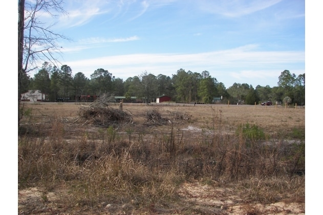
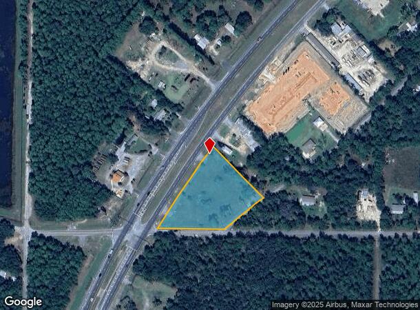
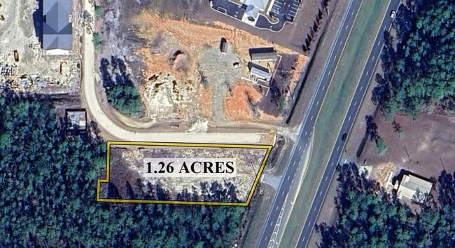
S Us Highway 331 Rd S, Freeport, FL 32439
NEARBY LISTINGS FOR SALE OR LEASE
Property Detail
S Us Highway 331 Rd S
Crestview-Fort Walton Beach-Destin, FL
COM SE/C OF NE4, S 00 DEG 20 W 125.85 FT, THENCE N 89 DEG 3230 W, 1736.27 FT TO POB THENCE ALONG R/W N 89 DEG 32 30 W, 316.78 FT TO E R/W OF SR 83, SAID PT BEING ON THE ARC OF A CURVE HAVING A CENTRAL ANGLE OF 4 DEG 5803 AND A RADIUS OF 5669.65 FT TH
04-2S-19-24000-001-0120
Walton
Vacantlandnec
Florida
X
120
12131C0567H
2.47 AC
2025
Florida Panhandle Area
2025
Other Market Areas
950502
DEMOGRAPHICS near S Us Highway 331 Rd S
1 Mile
3 Mile
5 Mile
2024 Total Population
469
2,525
11,670
2029 Population
576
3,095
14,425
Pop Growth 2024-2029
+ 22.81%
+ 22.57%
+ 23.61%
Average Age
38
39
38
2024 Total Households
172
939
4,340
HH Growth 2024-2029
+ 22.67%
+ 22.79%
+ 23.85%
Median Household Inc
$61,428
$51,591
$61,256
Avg Household Size
2.60
2.60
2.60
2024 Avg HH Vehicles
2.00
2.00
2.00
Median Home Value
$299,999
$274,615
$332,442
Median Year Built
2000
2002
2005
Nearby Places
Map Layers
Map Styles
 Street
 Aerial
- Restaurants
- Banks
- Shops
- Fitness
- Groceries
PUBLIC TRANSPORTATION
AIRPORT
Eglin AFB/Destin-Ft Walton Beach
DRIVE
WALK
Distance
Eglin AFB/Destin-Ft Walton Beach
68 min
34.3 mi
Northwest Florida Beaches International
DRIVE
WALK
Distance
Northwest Florida Beaches International
48 min
34.9 mi
Freight Ports
Port of Panama City
DRIVE
WALK
Distance
Port of Panama City
55 min
37.0 mi
SALE & LEASE HISTORY
LISTING DATE
SALE/LEASE

Oct 25, 2024
For Sale
Jul 28, 2025
For Sale
Nearby Properties
Address
Land Use
TOTAL SIZE
Lot Size
Zoning
Address
Land Use
TOTAL SIZE
Lot Size
Zoning
2,072 SF
23.08 AC
MUNI
Address
Land Use
TOTAL SIZE
Lot Size
Zoning
9,475 SF
8.45 AC
3310
Address
Land Use
TOTAL SIZE
Lot Size
Zoning
25,532 SF
4.24 AC
Address
Land Use
TOTAL SIZE
Lot Size
Zoning
1,240 SF
99.84 AC
BYLAGR
Address
Land Use
TOTAL SIZE
Lot Size
Zoning
2.14 AC
BAYN
Address
Land Use
TOTAL SIZE
Lot Size
Zoning
24.46 AC
Address
Land Use
TOTAL SIZE
Lot Size
Zoning
20,456 SF
3.64 AC
Address
Land Use
TOTAL SIZE
Lot Size
Zoning
10,857 SF
2.02 AC
3310
Address
Land Use
TOTAL SIZE
Lot Size
Zoning
6,465 SF
3.41 AC
BYLAGR
Address
Land Use
TOTAL SIZE
Lot Size
Zoning
1,674 SF
70.31 AC
RV
Address
Land Use
TOTAL SIZE
Lot Size
Zoning
3.06 AC
BAYN
Address
Land Use
TOTAL SIZE
Lot Size
Zoning
13.46 AC
Address
Land Use
TOTAL SIZE
Lot Size
Zoning
13,900 SF
1.96 AC
3310
Address
Land Use
TOTAL SIZE
Lot Size
Zoning
3,705 SF
0.92 AC
BAYN
Address
Land Use
TOTAL SIZE
Lot Size
Zoning
1.12 AC
BAYN
Address
Land Use
TOTAL SIZE
Lot Size
Zoning
1,968 SF
1.56 AC
BAYN
Address
Land Use
TOTAL SIZE
Lot Size
Zoning
6,140 SF
0.61 AC
3310
Address
Land Use
TOTAL SIZE
Lot Size
Zoning
3,844 SF
3.21 AC
BYLAGR
Address
Land Use
TOTAL SIZE
Lot Size
Zoning
9,363 SF
44.83 AC
BAYN
Address
Land Use
TOTAL SIZE
Lot Size
Zoning
6.12 AC
Address
Land Use
TOTAL SIZE
Lot Size
Zoning
23,219 SF
3.31 AC
3310
Address
Land Use
TOTAL SIZE
Lot Size
Zoning
4.83 AC
3310
Address
Land Use
TOTAL SIZE
Lot Size
Zoning
720 SF
3.41 AC
3310
Address
Land Use
TOTAL SIZE
Lot Size
Zoning
4,539 SF
31.24 AC
BAYN
Address
Land Use
TOTAL SIZE
Lot Size
Zoning
5,453 SF
0.40 AC
RV
Address
Land Use
TOTAL SIZE
Lot Size
Zoning
6.52 AC
BYLAGR
Address
Land Use
TOTAL SIZE
Lot Size
Zoning
8,074 SF
17.96 AC
R1
Address
Land Use
TOTAL SIZE
Lot Size
Zoning
5.29 AC
3310
The World's #1 Commercial Real Estate Marketplace
Connect with us
© 2026 CoStar Group
The information above has been obtained from sources believed reliable. While we do not doubt its accuracy we have not verified it and make no guarantee, warranty or representation about it. It is your responsibility to independently confirm its accuracy and completeness. Any projections, opinions, assumptions, or estimates used are for example only and do not represent the current or future performance of the property. The value of this transaction to you depends on tax and other factors which should be evaluated by your tax, financial, and legal advisors. You and your advisors should conduct a careful, independent investigation of the property to determine to your satisfaction the suitability of the property for your needs.