Property Record
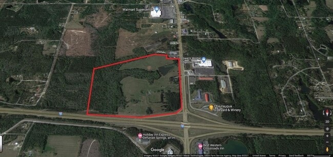
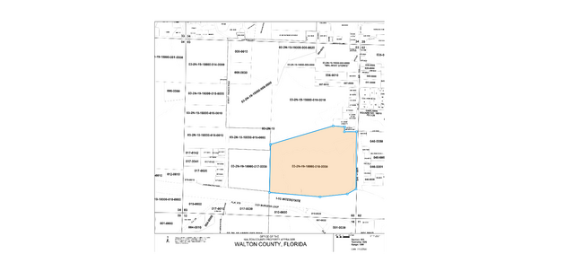
S Us Highway 331 S, Defuniak Springs, FL 32435

NEARBY LISTINGS FOR SALE OR LEASE
Property Detail
S Us Highway 331 S
03-2N-19-18000-010-0000
A PORTION OF THE FOLLOWING LYING N OF I-10 & W OF US HWY 331 S DB 114-571 DB 114-578 LESS & EXCEPT: OR 137-639 & OR 597-348 ALL LYING IN SEC 03-2N-19W, DESC AS FOLLOWS: COM NE/C OF SEC 03 S 01 4537W ALG E LINE OF SAID SEC 2701.47FT TO INT WITH ELY EX
Commercialacreage
Walton
A
Florida
12131C0280G
98.46 AC
2025
Florida Panhandle Area
2025
Other Market Areas
950305
Crestview-Fort Walton Beach-Destin, FL
2,967 SF
DEMOGRAPHICS near S Us Highway 331 S
1 Mile
3 Mile
5 Mile
2024 Total Population
226
4,956
10,551
2029 Population
270
5,901
12,642
Pop Growth 2024-2029
+ 19.47%
+ 19.07%
+ 19.82%
Average Age
41
39
39
2024 Total Households
81
1,731
3,487
HH Growth 2024-2029
+ 19.75%
+ 18.89%
+ 19.73%
Median Household Inc
$40,714
$39,173
$39,506
Avg Household Size
2.50
2.50
2.50
2024 Avg HH Vehicles
2.00
2.00
2.00
Median Home Value
$87,499
$99,234
$98,400
Median Year Built
1988
1986
1990
Nearby Places
Map Layers
Map Styles
 Street
 Aerial
- Restaurants
- Banks
- Shops
- Fitness
- Groceries
PUBLIC TRANSPORTATION
AIRPORT
Eglin AFB/Destin-Ft Walton Beach
DRIVE
WALK
Distance
Eglin AFB/Destin-Ft Walton Beach
64 min
38.0 mi
Freight Ports
Port of Panama City
DRIVE
WALK
Distance
Port of Panama City
109 min
85.4 mi
SALE & LEASE HISTORY
LISTING DATE
SALE/LEASE

Jun 03, 2022
For Sale
Nearby Properties
Address
Land Use
TOTAL SIZE
Lot Size
Zoning
Address
Land Use
TOTAL SIZE
Lot Size
Zoning
174,929 SF
9.32 AC
HD1
Address
Land Use
TOTAL SIZE
Lot Size
Zoning
41,056 SF
2.22 AC
3310
Address
Land Use
TOTAL SIZE
Lot Size
Zoning
96,057 SF
10.37 AC
W END
Address
Land Use
TOTAL SIZE
Lot Size
Zoning
54,534 SF
7.33 AC
MUNI
Address
Land Use
TOTAL SIZE
Lot Size
Zoning
160,339 SF
19.76 AC
3310
Address
Land Use
TOTAL SIZE
Lot Size
Zoning
37,731 SF
15.96 AC
Address
Land Use
TOTAL SIZE
Lot Size
Zoning
53,201 SF
14.45 AC
Address
Land Use
TOTAL SIZE
Lot Size
Zoning
101,840 SF
11.04 AC
3310
Address
Land Use
TOTAL SIZE
Lot Size
Zoning
126,076 SF
11.38 AC
3310
Address
Land Use
TOTAL SIZE
Lot Size
Zoning
10,655 SF
163.72 AC
MUNI
Address
Land Use
TOTAL SIZE
Lot Size
Zoning
109,921 SF
2.25 AC
Address
Land Use
TOTAL SIZE
Lot Size
Zoning
52,428 SF
4.66 AC
3310
Address
Land Use
TOTAL SIZE
Lot Size
Zoning
68,153 SF
9.65 AC
3310
Address
Land Use
TOTAL SIZE
Lot Size
Zoning
44,789 SF
4.34 AC
Address
Land Use
TOTAL SIZE
Lot Size
Zoning
61,948 SF
9.26 AC
3310
Address
Land Use
TOTAL SIZE
Lot Size
Zoning
15,264 SF
3.24 AC
3310
Address
Land Use
TOTAL SIZE
Lot Size
Zoning
15,587 SF
5.54 AC
Address
Land Use
TOTAL SIZE
Lot Size
Zoning
5,951 SF
1.64 AC
3310
Address
Land Use
TOTAL SIZE
Lot Size
Zoning
48,394 SF
8.79 AC
3310
Address
Land Use
TOTAL SIZE
Lot Size
Zoning
Address
Land Use
TOTAL SIZE
Lot Size
Zoning
70,200 SF
5.25 AC
3310
Address
Land Use
TOTAL SIZE
Lot Size
Zoning
104,680 SF
10 AC
Address
Land Use
TOTAL SIZE
Lot Size
Zoning
13,793 SF
2.80 AC
3310
Address
Land Use
TOTAL SIZE
Lot Size
Zoning
23,674 SF
12.03 AC
3310
Address
Land Use
TOTAL SIZE
Lot Size
Zoning
32,375 SF
6.46 AC
HWY90
Address
Land Use
TOTAL SIZE
Lot Size
Zoning
17,310 SF
13.26 AC
3310
Address
Land Use
TOTAL SIZE
Lot Size
Zoning
35,967 SF
4.11 AC
Address
Land Use
TOTAL SIZE
Lot Size
Zoning
14,525 SF
0.90 AC
HWY90
Address
Land Use
TOTAL SIZE
Lot Size
Zoning
17,376 SF
79.90 AC
HD1
The World's #1 Commercial Real Estate Marketplace
Connect with us
© 2026 CoStar Group
The information above has been obtained from sources believed reliable. While we do not doubt its accuracy we have not verified it and make no guarantee, warranty or representation about it. It is your responsibility to independently confirm its accuracy and completeness. Any projections, opinions, assumptions, or estimates used are for example only and do not represent the current or future performance of the property. The value of this transaction to you depends on tax and other factors which should be evaluated by your tax, financial, and legal advisors. You and your advisors should conduct a careful, independent investigation of the property to determine to your satisfaction the suitability of the property for your needs.