Property Record
15025 S Us Highway 395 St S, Reno, NV 89511
Property Detail
15025 S Us Highway 395 St S
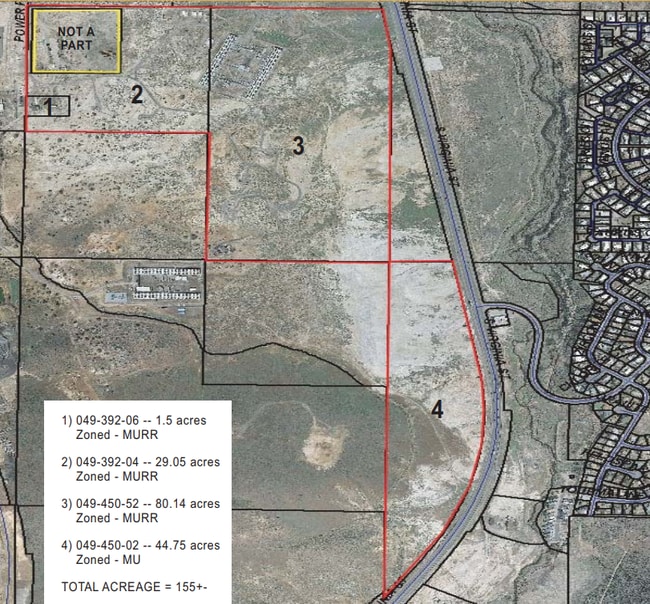
049-392-04
ROS 6633 PAR A
Governmentalpublicusegeneral
WASHOE
I
Nevada
B and X Area of moderate flood hazard, usually the area between the limits of the 100-year and 500-year floods.
a
2024
88.54 AC
2026
S Outlying Washoe County
001013
Reno/Sparks
7,622 SF
Reno, NV
NEARBY LISTINGS FOR SALE OR LEASE
DEMOGRAPHICS near 15025 S Us Highway 395 St S
1 mile
3 mile
5 mile
2025 Total Population
3,270
31,405
65,870
2030 Population
3,416
33,004
68,465
Pop Growth 2025-2030
+ 4.46%
+ 5.09%
+ 3.94%
Average Age
43
42
43
2025 Total Households
1,340
12,339
26,477
HH Growth 2025-2030
+ 4.55%
+ 5.09%
+ 3.98%
Median Household Inc
$69,999
$114,270
$120,553
Avg Household Size
2.40
2.50
2.50
2025 Avg HH Vehicles
2.00
2.00
2.00
Median Home Value
$622,829
$738,108
$770,864
Median Year Built
1981
2005
2005
Nearby Places
Map Layers
Map Styles
 Street
 Aerial
Transit
 Traffic
 Biking
Places
Listings with unknown addresses are not visible on the map
- Restaurants
- Banks
- Shops
- Fitness
- Groceries
PUBLIC TRANSPORTATION
AIRPORT
Reno/Tahoe International
Drive
Walk
Distance
Reno/Tahoe International
30 min
11.9 mi
Freight Ports
Port of Stockton
Drive
Walk
Distance
Port of Stockton
222 min
191.2 mi
SALE & LEASE HISTORY
LISTING DATE
SALE/LEASE

Sep 24, 2016
For Sale
Mar 28, 2019
For Sale
Mar 23, 2017
For Sale
Nearby Properties
Address
Land Use
TOTAL SIZE
Lot Size
Zoning
Address
Land Use
TOTAL SIZE
Lot Size
Zoning
271,546 SF
20.62 AC
PD
Address
Land Use
TOTAL SIZE
Lot Size
Zoning
476,624 SF
19.33 AC
PD
Address
Land Use
TOTAL SIZE
Lot Size
Zoning
418,177 SF
16.59 AC
MS
Address
Land Use
TOTAL SIZE
Lot Size
Zoning
430,526 SF
14.79 AC
MS
Address
Land Use
TOTAL SIZE
Lot Size
Zoning
191,762 SF
51.49 AC
LDS
Address
Land Use
TOTAL SIZE
Lot Size
Zoning
410,834 SF
11.58 AC
MS
Address
Land Use
TOTAL SIZE
Lot Size
Zoning
308,769 SF
17.53 AC
PD
Address
Land Use
TOTAL SIZE
Lot Size
Zoning
389,745 SF
15.17 AC
MS
Address
Land Use
TOTAL SIZE
Lot Size
Zoning
327,867 SF
12.11 AC
PD
Address
Land Use
TOTAL SIZE
Lot Size
Zoning
181,150 SF
27.71 AC
PD
Address
Land Use
TOTAL SIZE
Lot Size
Zoning
379,347 SF
18.42 AC
MS
Address
Land Use
TOTAL SIZE
Lot Size
Zoning
476,624 SF
19.50 AC
PD
Address
Land Use
TOTAL SIZE
Lot Size
Zoning
257,652 SF
23.36 AC
MS
Address
Land Use
TOTAL SIZE
Lot Size
Zoning
310,004 SF
11.77 AC
PD
Address
Land Use
TOTAL SIZE
Lot Size
Zoning
283,103 SF
10.02 AC
PD
Address
Land Use
TOTAL SIZE
Lot Size
Zoning
276,780 SF
60.26 AC
PD
Address
Land Use
TOTAL SIZE
Lot Size
Zoning
296,169 SF
15.33 AC
MS
Address
Land Use
TOTAL SIZE
Lot Size
Zoning
392,820 SF
24.82 AC
MS
Address
Land Use
TOTAL SIZE
Lot Size
Zoning
151,254 SF
48.11 AC
MDS
Address
Land Use
TOTAL SIZE
Lot Size
Zoning
389,667 SF
19.52 AC
MS
Address
Land Use
TOTAL SIZE
Lot Size
Zoning
240,094 SF
8.16 AC
MS
Address
Land Use
TOTAL SIZE
Lot Size
Zoning
209,359 SF
10.98 AC
PD
Address
Land Use
TOTAL SIZE
Lot Size
Zoning
601,250 SF
27.39 AC
MS
Address
Land Use
TOTAL SIZE
Lot Size
Zoning
212,660 SF
5.21 AC
MS
Address
Land Use
TOTAL SIZE
Lot Size
Zoning
110,100 SF
22.88 AC
MS
Address
Land Use
TOTAL SIZE
Lot Size
Zoning
284,689 SF
10.63 AC
MS
Address
Land Use
TOTAL SIZE
Lot Size
Zoning
167,612 SF
7.88 AC
PD
Address
Land Use
TOTAL SIZE
Lot Size
Zoning
225,634 SF
66.85 AC
PSP
Address
Land Use
TOTAL SIZE
Lot Size
Zoning
25.52 AC
MS
Address
Land Use
TOTAL SIZE
Lot Size
Zoning
47,743 SF
7.27 AC
MS
The World's #1 Commercial Real Estate Marketplace
Connect with us
© 2026 CoStar Group
The information above has been obtained from sources believed reliable. While we do not doubt its accuracy we have not verified it and make no guarantee, warranty or representation about it. It is your responsibility to independently confirm its accuracy and completeness. Any projections, opinions, assumptions, or estimates used are for example only and do not represent the current or future performance of the property. The value of this transaction to you depends on tax and other factors which should be evaluated by your tax, financial, and legal advisors. You and your advisors should conduct a careful, independent investigation of the property to determine to your satisfaction the suitability of the property for your needs.