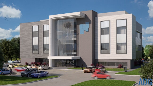
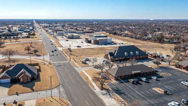
Property Record
11501 S Western Ave, Oklahoma City, OK 73170

Current Lease Availabilities
NEARBY LISTINGS FOR SALE OR LEASE
Property Detail
11501 S Western Ave
R0188639
8-10-3W 1.54 AC PRT SE/4 BEG 1484.16`N SE/C SE/4 W290` S200` W220` N396` N 29D W200.16` N 63D E178` E397.65` N155` E50` S608` POB LESS BEG 1484.16`N SE/C SE/4 W290` S200` W220` N396` N 29D W200.18` N 63D E178` N 38D E2.35` S150.20` E447.92` S302.80`
Religious
Cleveland
X
Oklahoma
40027C0157K
1.54 AC
2024
Moore
2024
Oklahoma City
201802
Oklahoma City, OK
DEMOGRAPHICS near 11501 S Western Ave
1 Mile
3 Mile
5 Mile
2024 Total Population
10,405
96,666
189,376
2029 Population
10,789
99,840
195,054
Pop Growth 2024-2029
+ 3.69%
+ 3.28%
+ 3.00%
Average Age
43
39
37
2024 Total Households
4,449
38,194
71,142
HH Growth 2024-2029
+ 4.00%
+ 3.48%
+ 3.18%
Median Household Inc
$69,644
$62,360
$59,440
Avg Household Size
2.20
2.50
2.60
2024 Avg HH Vehicles
2.00
2.00
2.00
Median Home Value
$203,611
$169,481
$160,893
Median Year Built
1990
1985
1981
Nearby Places
Map Layers
Map Styles
 Street
 Aerial
- Restaurants
- Banks
- Shops
- Fitness
- Groceries
PUBLIC TRANSPORTATION
COMMUTER RAIL
Oklahoma City (Heartland Flyer - Amtrak)
DRIVE
WALK
Distance
Oklahoma City (Heartland Flyer - Amtrak)
15 min
9.1 mi
AIRPORT
Will Rogers World
DRIVE
WALK
Distance
Will Rogers World
19 min
8.8 mi
Freight Ports
Tulsa Port Of Catoosa
DRIVE
WALK
Distance
Tulsa Port Of Catoosa
146 min
132.3 mi
Nearby Properties
Address
Land Use
TOTAL SIZE
Lot Size
Zoning
Address
Land Use
TOTAL SIZE
Lot Size
Zoning
210,816 SF
10.45 AC
Address
Land Use
TOTAL SIZE
Lot Size
Zoning
1,600 SF
25 AC
Address
Land Use
TOTAL SIZE
Lot Size
Zoning
50.08 AC
Address
Land Use
TOTAL SIZE
Lot Size
Zoning
125,954 SF
11.92 AC
R4
Address
Land Use
TOTAL SIZE
Lot Size
Zoning
29.38 AC
Address
Land Use
TOTAL SIZE
Lot Size
Zoning
0.16 AC
C6
Address
Land Use
TOTAL SIZE
Lot Size
Zoning
2,123 SF
53.41 AC
C3
Address
Land Use
TOTAL SIZE
Lot Size
Zoning
40.15 AC
AA
Address
Land Use
TOTAL SIZE
Lot Size
Zoning
155.94 AC
Address
Land Use
TOTAL SIZE
Lot Size
Zoning
Address
Land Use
TOTAL SIZE
Lot Size
Zoning
5.14 AC
Address
Land Use
TOTAL SIZE
Lot Size
Zoning
57,536 SF
66.21 AC
R4
Address
Land Use
TOTAL SIZE
Lot Size
Zoning
15.61 AC
C1
Address
Land Use
TOTAL SIZE
Lot Size
Zoning
Address
Land Use
TOTAL SIZE
Lot Size
Zoning
10 AC
R2
Address
Land Use
TOTAL SIZE
Lot Size
Zoning
Address
Land Use
TOTAL SIZE
Lot Size
Zoning
347,050 SF
18.56 AC
Address
Land Use
TOTAL SIZE
Lot Size
Zoning
40.90 AC
Address
Land Use
TOTAL SIZE
Lot Size
Zoning
0.77 AC
Address
Land Use
TOTAL SIZE
Lot Size
Zoning
Address
Land Use
TOTAL SIZE
Lot Size
Zoning
384,708 SF
17.05 AC
R-4
Address
Land Use
TOTAL SIZE
Lot Size
Zoning
14,714 SF
14.41 AC
Address
Land Use
TOTAL SIZE
Lot Size
Zoning
0.64 AC
Address
Land Use
TOTAL SIZE
Lot Size
Zoning
1.40 AC
Address
Land Use
TOTAL SIZE
Lot Size
Zoning
104.87 AC
Address
Land Use
TOTAL SIZE
Lot Size
Zoning
27,056 SF
40.77 AC
Address
Land Use
TOTAL SIZE
Lot Size
Zoning
232,037 SF
18.80 AC
C-3
Address
Land Use
TOTAL SIZE
Lot Size
Zoning
403,745 SF
26.03 AC
I-3
Address
Land Use
TOTAL SIZE
Lot Size
Zoning
37,127 SF
21.90 AC
R4
Address
Land Use
TOTAL SIZE
Lot Size
Zoning
12,000 SF
8.89 AC
The World's #1 Commercial Real Estate Marketplace
Connect with us
© 2026 CoStar Group
The information above has been obtained from sources believed reliable. While we do not doubt its accuracy we have not verified it and make no guarantee, warranty or representation about it. It is your responsibility to independently confirm its accuracy and completeness. Any projections, opinions, assumptions, or estimates used are for example only and do not represent the current or future performance of the property. The value of this transaction to you depends on tax and other factors which should be evaluated by your tax, financial, and legal advisors. You and your advisors should conduct a careful, independent investigation of the property to determine to your satisfaction the suitability of the property for your needs.