Property Record
S1381a Coon Bluff Rd, Wisconsin Dells, WI 53965

NEARBY LISTINGS FOR SALE OR LEASE
-
-
View all Wisconsin Dells listings for sale on LoopNet.com
Property Detail
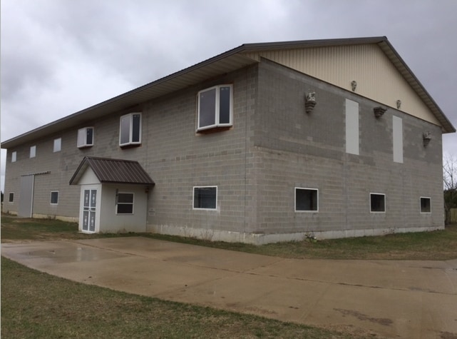
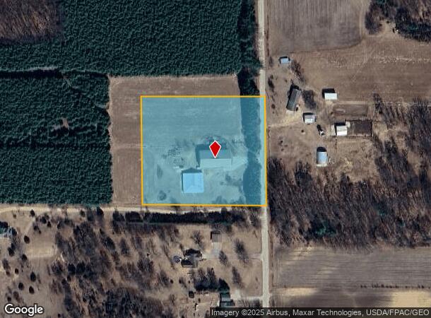
S1381a Coon Bluff Rd
Baraboo, WI
Certidfied Survey Map No 6205
006-0486-00000
S 23-13-5 PRT NE1/4 NW1/4 = CSM 6205 LOT 1 5.00A
Commercialnec
Sauk
X
Wisconsin
55021C0200F
1
2024
5 AC
2024
Other Market Areas
000200
DEMOGRAPHICS near S1381a Coon Bluff Rd
1 Mile
3 Mile
5 Mile
2024 Total Population
185
2,730
6,899
2029 Population
176
2,618
6,892
Pop Growth 2024-2029
(4.86%)
(4.10%)
(0.10%)
Average Age
42
42
41
2024 Total Households
71
1,057
2,807
HH Growth 2024-2029
(5.63%)
(4.26%)
0.00%
Median Household Inc
$89,999
$87,071
$75,022
Avg Household Size
2.60
2.60
2.40
2024 Avg HH Vehicles
3.00
3.00
2.00
Median Home Value
$292,856
$253,999
$190,969
Median Year Built
1998
1995
1992
Nearby Places
Map Layers
Map Styles
 Street
 Aerial
- Restaurants
- Banks
- Shops
- Fitness
- Groceries
PUBLIC TRANSPORTATION
COMMUTER RAIL
Wisconsin Dells Amtrak Station (Empire Builder - Amtrak)
DRIVE
WALK
Distance
Wisconsin Dells Amtrak Station (Empire Builder - Amtrak)
13 min
7.3 mi
Freight Ports
Port Milwaukee
DRIVE
WALK
Distance
Port Milwaukee
142 min
124.2 mi
SALE & LEASE HISTORY
LISTING DATE
SALE/LEASE

Sep 23, 2016
For Sale
Oct 26, 2016
For Sale
May 23, 2017
For Sale
Nearby Properties
Address
Land Use
TOTAL SIZE
Lot Size
Zoning
Address
Land Use
TOTAL SIZE
Lot Size
Zoning
16.22 AC
Address
Land Use
TOTAL SIZE
Lot Size
Zoning
18.32 AC
Address
Land Use
TOTAL SIZE
Lot Size
Zoning
16.48 AC
Address
Land Use
TOTAL SIZE
Lot Size
Zoning
52.23 AC
Address
Land Use
TOTAL SIZE
Lot Size
Zoning
14.73 AC
Address
Land Use
TOTAL SIZE
Lot Size
Zoning
Address
Land Use
TOTAL SIZE
Lot Size
Zoning
Address
Land Use
TOTAL SIZE
Lot Size
Zoning
Address
Land Use
TOTAL SIZE
Lot Size
Zoning
Address
Land Use
TOTAL SIZE
Lot Size
Zoning
Address
Land Use
TOTAL SIZE
Lot Size
Zoning
19.97 AC
Address
Land Use
TOTAL SIZE
Lot Size
Zoning
Address
Land Use
TOTAL SIZE
Lot Size
Zoning
Address
Land Use
TOTAL SIZE
Lot Size
Zoning
Address
Land Use
TOTAL SIZE
Lot Size
Zoning
Address
Land Use
TOTAL SIZE
Lot Size
Zoning
Address
Land Use
TOTAL SIZE
Lot Size
Zoning
Address
Land Use
TOTAL SIZE
Lot Size
Zoning
Address
Land Use
TOTAL SIZE
Lot Size
Zoning
Address
Land Use
TOTAL SIZE
Lot Size
Zoning
0.84 AC
Address
Land Use
TOTAL SIZE
Lot Size
Zoning
Address
Land Use
TOTAL SIZE
Lot Size
Zoning
Address
Land Use
TOTAL SIZE
Lot Size
Zoning
Address
Land Use
TOTAL SIZE
Lot Size
Zoning
21.99 AC
Address
Land Use
TOTAL SIZE
Lot Size
Zoning
Address
Land Use
TOTAL SIZE
Lot Size
Zoning
Address
Land Use
TOTAL SIZE
Lot Size
Zoning
Address
Land Use
TOTAL SIZE
Lot Size
Zoning
Address
Land Use
TOTAL SIZE
Lot Size
Zoning
The World's #1 Commercial Real Estate Marketplace
Connect with us
© 2026 CoStar Group
The information above has been obtained from sources believed reliable. While we do not doubt its accuracy we have not verified it and make no guarantee, warranty or representation about it. It is your responsibility to independently confirm its accuracy and completeness. Any projections, opinions, assumptions, or estimates used are for example only and do not represent the current or future performance of the property. The value of this transaction to you depends on tax and other factors which should be evaluated by your tax, financial, and legal advisors. You and your advisors should conduct a careful, independent investigation of the property to determine to your satisfaction the suitability of the property for your needs.