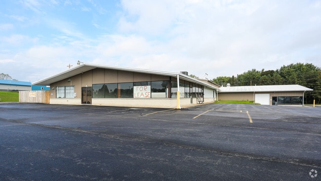
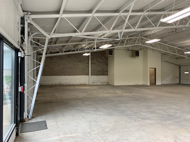
Property Record
S47w30760 State Road 59, North Prairie, WI 53153

NEARBY LISTINGS FOR SALE OR LEASE
Property Detail
S47w30760 State Road 59
Milwaukee-Waukesha-West Allis, WI
OUTLOT 1 CERT SURV 7207 VOL 61/10 PT NW1/4 SEC 27 T6N R18E; ALSO PT LOT 2 CERT SURV 7207 COM NELY COR OUTLOT 1 N503342W 72.560 FT; N174814W 95.131 FT; N005939W 91.417 FT; S204900W 243.970 FT TO BGN; ALSO PT NW1/4 SEC 27 COM NW COR NW1/4 S895500E 797.
GNT-1546-966
Waukesha
Commercialnec
Wisconsin
X
2
55133C0303H
4.36 AC
2024
SW/Mukwonago
2024
Milwaukee/Madison
203803
DEMOGRAPHICS near S47w30760 State Road 59
1 Mile
3 Mile
5 Mile
2024 Total Population
763
7,979
23,771
2029 Population
778
8,098
24,256
Pop Growth 2024-2029
+ 1.97%
+ 1.49%
+ 2.04%
Average Age
44
45
43
2024 Total Households
289
3,020
8,803
HH Growth 2024-2029
+ 1.73%
+ 1.46%
+ 1.99%
Median Household Inc
$117,982
$115,685
$117,048
Avg Household Size
2.60
2.60
2.70
2024 Avg HH Vehicles
2.00
2.00
2.00
Median Home Value
$395,061
$382,409
$366,415
Median Year Built
1979
1979
1987
Nearby Places
Map Layers
Map Styles
 Street
 Aerial
- Restaurants
- Banks
- Shops
- Fitness
- Groceries
PUBLIC TRANSPORTATION
AIRPORT
General Mitchell International
DRIVE
WALK
Distance
General Mitchell International
45 min
30.1 mi
Freight Ports
Port Milwaukee
DRIVE
WALK
Distance
Port Milwaukee
45 min
32.0 mi
SALE & LEASE HISTORY
LISTING DATE
SALE/LEASE

Nov 16, 2018
For Lease
Nearby Properties
Address
Land Use
TOTAL SIZE
Lot Size
Zoning
Address
Land Use
TOTAL SIZE
Lot Size
Zoning
Address
Land Use
TOTAL SIZE
Lot Size
Zoning
Address
Land Use
TOTAL SIZE
Lot Size
Zoning
75.05 AC
Address
Land Use
TOTAL SIZE
Lot Size
Zoning
Address
Land Use
TOTAL SIZE
Lot Size
Zoning
82.42 AC
Address
Land Use
TOTAL SIZE
Lot Size
Zoning
Address
Land Use
TOTAL SIZE
Lot Size
Zoning
Address
Land Use
TOTAL SIZE
Lot Size
Zoning
Address
Land Use
TOTAL SIZE
Lot Size
Zoning
Address
Land Use
TOTAL SIZE
Lot Size
Zoning
Address
Land Use
TOTAL SIZE
Lot Size
Zoning
Address
Land Use
TOTAL SIZE
Lot Size
Zoning
33.83 AC
Address
Land Use
TOTAL SIZE
Lot Size
Zoning
157.38 AC
Address
Land Use
TOTAL SIZE
Lot Size
Zoning
Address
Land Use
TOTAL SIZE
Lot Size
Zoning
Address
Land Use
TOTAL SIZE
Lot Size
Zoning
Address
Land Use
TOTAL SIZE
Lot Size
Zoning
Address
Land Use
TOTAL SIZE
Lot Size
Zoning
21.26 AC
Address
Land Use
TOTAL SIZE
Lot Size
Zoning
Address
Land Use
TOTAL SIZE
Lot Size
Zoning
Address
Land Use
TOTAL SIZE
Lot Size
Zoning
Address
Land Use
TOTAL SIZE
Lot Size
Zoning
18.29 AC
Address
Land Use
TOTAL SIZE
Lot Size
Zoning
Address
Land Use
TOTAL SIZE
Lot Size
Zoning
33.96 AC
Address
Land Use
TOTAL SIZE
Lot Size
Zoning
Address
Land Use
TOTAL SIZE
Lot Size
Zoning
Address
Land Use
TOTAL SIZE
Lot Size
Zoning
Address
Land Use
TOTAL SIZE
Lot Size
Zoning
Address
Land Use
TOTAL SIZE
Lot Size
Zoning
143.24 AC
The World's #1 Commercial Real Estate Marketplace
Connect with us
© 2025 CoStar Group
The information above has been obtained from sources believed reliable. While we do not doubt its accuracy we have not verified it and make no guarantee, warranty or representation about it. It is your responsibility to independently confirm its accuracy and completeness. Any projections, opinions, assumptions, or estimates used are for example only and do not represent the current or future performance of the property. The value of this transaction to you depends on tax and other factors which should be evaluated by your tax, financial, and legal advisors. You and your advisors should conduct a careful, independent investigation of the property to determine to your satisfaction the suitability of the property for your needs.