Property Record
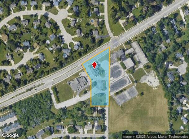
S67w14831 Janesville Rd, Muskego, WI 53150
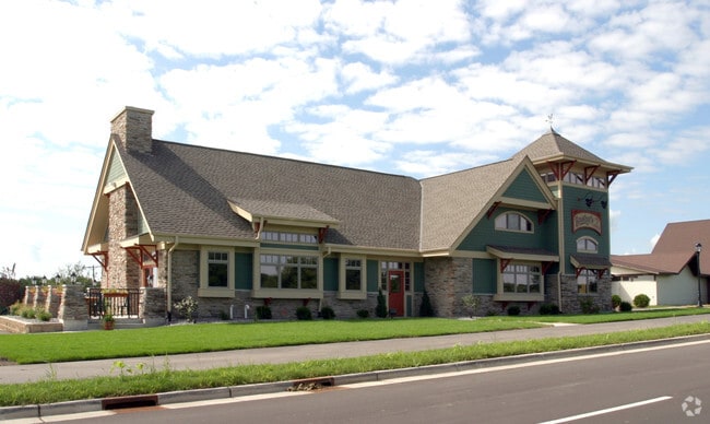
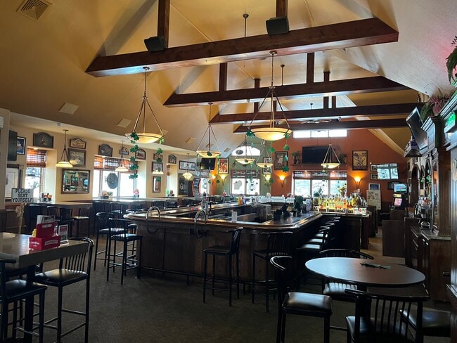
This Property Is For Sale
NEARBY LISTINGS FOR SALE OR LEASE
Property Detail
S67w14831 Janesville Rd
Milwaukee-Waukesha-West Allis, WI
PT SW1/4 SEC 2 T5N R20E; COM S1/4 CRNR; N 513 FT; S 260 FT; S87 1/4W 185 FT 3 IN; N32W 130 FT TO CNTR OF HWY; N58E IN CNTR OF HWY 300 FT TO BGN :: EX DOC #3174510 :: ALSO DOC #3169094 CORRECTED BY DOC #3597641 :: ALSO EASEMENT RECORDED AS DOC #318418
MSKC-2167-997-001
Waukesha
Commercialnec
Wisconsin
X
5n
55133C0361H
1.43 AC
2024
SE/Muskego
2024
Milwaukee/Madison
201703
DEMOGRAPHICS near S67w14831 Janesville Rd
1 Mile
3 Mile
5 Mile
2024 Total Population
3,876
33,990
91,472
2029 Population
3,908
34,305
91,881
Pop Growth 2024-2029
+ 0.83%
+ 0.93%
+ 0.45%
Average Age
45
44
45
2024 Total Households
1,572
13,870
38,075
HH Growth 2024-2029
+ 0.76%
+ 0.84%
+ 0.38%
Median Household Inc
$96,914
$97,638
$95,252
Avg Household Size
2.50
2.40
2.40
2024 Avg HH Vehicles
2.00
2.00
2.00
Median Home Value
$333,272
$324,667
$322,678
Median Year Built
1974
1978
1982
Nearby Places
- Restaurants
- Banks
- Shops
- Fitness
- Groceries
PUBLIC TRANSPORTATION
AIRPORT
General Mitchell International
DRIVE
WALK
Distance
General Mitchell International
23 min
11.9 mi
Nearby Properties
Address
Land Use
TOTAL SIZE
Lot Size
Zoning
Address
Land Use
TOTAL SIZE
Lot Size
Zoning
27.11 AC
Address
Land Use
TOTAL SIZE
Lot Size
Zoning
139,164 SF
25.94 AC
O2
Address
Land Use
TOTAL SIZE
Lot Size
Zoning
464,768 SF
34.90 AC
M1
Address
Land Use
TOTAL SIZE
Lot Size
Zoning
17.68 AC
Address
Land Use
TOTAL SIZE
Lot Size
Zoning
33.26 AC
Address
Land Use
TOTAL SIZE
Lot Size
Zoning
Address
Land Use
TOTAL SIZE
Lot Size
Zoning
15.24 AC
Address
Land Use
TOTAL SIZE
Lot Size
Zoning
154,897 SF
17.51 AC
O2
Address
Land Use
TOTAL SIZE
Lot Size
Zoning
74,309 SF
10.28 AC
O2
Address
Land Use
TOTAL SIZE
Lot Size
Zoning
Address
Land Use
TOTAL SIZE
Lot Size
Zoning
217,472 SF
21.27 AC
M1
Address
Land Use
TOTAL SIZE
Lot Size
Zoning
Address
Land Use
TOTAL SIZE
Lot Size
Zoning
146,270 SF
18 AC
O2
Address
Land Use
TOTAL SIZE
Lot Size
Zoning
Address
Land Use
TOTAL SIZE
Lot Size
Zoning
139,706 SF
16.50 AC
M1
Address
Land Use
TOTAL SIZE
Lot Size
Zoning
171,506 SF
11.85 AC
M1
Address
Land Use
TOTAL SIZE
Lot Size
Zoning
164,440 SF
11.63 AC
M1
Address
Land Use
TOTAL SIZE
Lot Size
Zoning
172,772 SF
13.53 AC
M1
Address
Land Use
TOTAL SIZE
Lot Size
Zoning
10.98 AC
Address
Land Use
TOTAL SIZE
Lot Size
Zoning
97,217 SF
18.38 AC
M1
Address
Land Use
TOTAL SIZE
Lot Size
Zoning
Address
Land Use
TOTAL SIZE
Lot Size
Zoning
Address
Land Use
TOTAL SIZE
Lot Size
Zoning
93,776 SF
7.94 AC
M1
Address
Land Use
TOTAL SIZE
Lot Size
Zoning
Address
Land Use
TOTAL SIZE
Lot Size
Zoning
56,052 SF
8.46 AC
O2
Address
Land Use
TOTAL SIZE
Lot Size
Zoning
162,366 SF
18.99 AC
Address
Land Use
TOTAL SIZE
Lot Size
Zoning
122,604 SF
11.12 AC
M1
Address
Land Use
TOTAL SIZE
Lot Size
Zoning
8.76 AC
B1
Address
Land Use
TOTAL SIZE
Lot Size
Zoning
15.88 AC
Address
Land Use
TOTAL SIZE
Lot Size
Zoning
200,160 SF
11.44 AC
M1
The World's #1 Commercial Real Estate Marketplace
Connect with us
© 2025 CoStar Group
The information above has been obtained from sources believed reliable. While we do not doubt its accuracy we have not verified it and make no guarantee, warranty or representation about it. It is your responsibility to independently confirm its accuracy and completeness. Any projections, opinions, assumptions, or estimates used are for example only and do not represent the current or future performance of the property. The value of this transaction to you depends on tax and other factors which should be evaluated by your tax, financial, and legal advisors. You and your advisors should conduct a careful, independent investigation of the property to determine to your satisfaction the suitability of the property for your needs.