Property Record
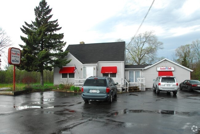
S73w16610 Janesville Rd, Muskego, WI 53150
NEARBY LISTINGS FOR SALE OR LEASE
Property Detail
S73w16610 Janesville Rd
Milwaukee-Waukesha-West Allis, WI
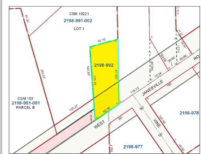
LOT 1 CERT SURV 10766 VOL 104/108 REC AS DOC# 3729473 REDIV LOT 1 CERT SURV 10221 & UNPLATTED LANDS ADJACENT TO SAID LOT 1 ON SE ALL BEING IN NE1/4 & SE1/4 OF NW1/4 SEC 10 T5N R20E :: DOC# 3690498
MSKC-2198-991-004
Waukesha
Commercialnec
Wisconsin
X
1
55133C0361H
2.06 AC
2024
SE/Muskego
2024
Milwaukee/Madison
201701
DEMOGRAPHICS near S73w16610 Janesville Rd
1 Mile
3 Mile
5 Mile
2024 Total Population
3,674
24,932
68,110
2029 Population
3,645
25,281
68,826
Pop Growth 2024-2029
(0.79%)
+ 1.40%
+ 1.05%
Average Age
44
44
44
2024 Total Households
1,483
9,795
27,553
HH Growth 2024-2029
(0.81%)
+ 1.36%
+ 0.92%
Median Household Inc
$96,199
$99,136
$99,849
Avg Household Size
2.40
2.50
2.40
2024 Avg HH Vehicles
2.00
2.00
2.00
Median Home Value
$375,333
$357,358
$334,948
Median Year Built
1988
1983
1981
Nearby Places
Map Layers
Map Styles
 Street
 Aerial
- Restaurants
- Banks
- Shops
- Fitness
- Groceries
PUBLIC TRANSPORTATION
AIRPORT
General Mitchell International
DRIVE
WALK
Distance
General Mitchell International
26 min
13.2 mi
Freight Ports
Port Milwaukee
DRIVE
WALK
Distance
Port Milwaukee
26 min
15.2 mi
Nearby Properties
Address
Land Use
TOTAL SIZE
Lot Size
Zoning
Address
Land Use
TOTAL SIZE
Lot Size
Zoning
464,768 SF
34.90 AC
M1
Address
Land Use
TOTAL SIZE
Lot Size
Zoning
17.68 AC
Address
Land Use
TOTAL SIZE
Lot Size
Zoning
33.26 AC
Address
Land Use
TOTAL SIZE
Lot Size
Zoning
370,169 SF
23.69 AC
RM1
Address
Land Use
TOTAL SIZE
Lot Size
Zoning
Address
Land Use
TOTAL SIZE
Lot Size
Zoning
174,869 SF
17.40 AC
RM1
Address
Land Use
TOTAL SIZE
Lot Size
Zoning
15.24 AC
Address
Land Use
TOTAL SIZE
Lot Size
Zoning
154,897 SF
17.51 AC
O2
Address
Land Use
TOTAL SIZE
Lot Size
Zoning
217,472 SF
21.27 AC
M1
Address
Land Use
TOTAL SIZE
Lot Size
Zoning
171,506 SF
11.85 AC
M1
Address
Land Use
TOTAL SIZE
Lot Size
Zoning
164,440 SF
11.63 AC
M1
Address
Land Use
TOTAL SIZE
Lot Size
Zoning
172,772 SF
13.53 AC
M1
Address
Land Use
TOTAL SIZE
Lot Size
Zoning
97,217 SF
18.38 AC
M1
Address
Land Use
TOTAL SIZE
Lot Size
Zoning
93,776 SF
7.94 AC
M1
Address
Land Use
TOTAL SIZE
Lot Size
Zoning
Address
Land Use
TOTAL SIZE
Lot Size
Zoning
56,052 SF
8.46 AC
O2
Address
Land Use
TOTAL SIZE
Lot Size
Zoning
122,604 SF
11.12 AC
M1
Address
Land Use
TOTAL SIZE
Lot Size
Zoning
15.88 AC
Address
Land Use
TOTAL SIZE
Lot Size
Zoning
200,160 SF
11.44 AC
M1
Address
Land Use
TOTAL SIZE
Lot Size
Zoning
119,787 SF
10.44 AC
M1
Address
Land Use
TOTAL SIZE
Lot Size
Zoning
Address
Land Use
TOTAL SIZE
Lot Size
Zoning
100,939 SF
8.97 AC
M1
Address
Land Use
TOTAL SIZE
Lot Size
Zoning
Address
Land Use
TOTAL SIZE
Lot Size
Zoning
110,101 SF
8.51 AC
M1
Address
Land Use
TOTAL SIZE
Lot Size
Zoning
91,972 SF
7.01 AC
M1
Address
Land Use
TOTAL SIZE
Lot Size
Zoning
Address
Land Use
TOTAL SIZE
Lot Size
Zoning
Address
Land Use
TOTAL SIZE
Lot Size
Zoning
Address
Land Use
TOTAL SIZE
Lot Size
Zoning
132,478 SF
13.29 AC
M1
Address
Land Use
TOTAL SIZE
Lot Size
Zoning
5.14 AC
The World's #1 Commercial Real Estate Marketplace
Connect with us
© 2025 CoStar Group
The information above has been obtained from sources believed reliable. While we do not doubt its accuracy we have not verified it and make no guarantee, warranty or representation about it. It is your responsibility to independently confirm its accuracy and completeness. Any projections, opinions, assumptions, or estimates used are for example only and do not represent the current or future performance of the property. The value of this transaction to you depends on tax and other factors which should be evaluated by your tax, financial, and legal advisors. You and your advisors should conduct a careful, independent investigation of the property to determine to your satisfaction the suitability of the property for your needs.