Property Record
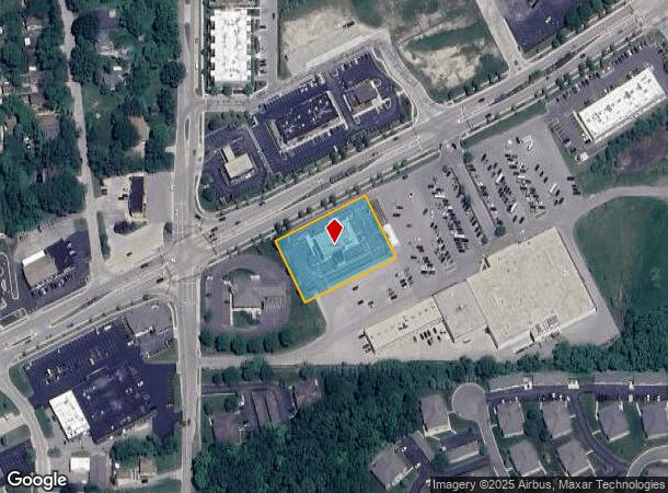
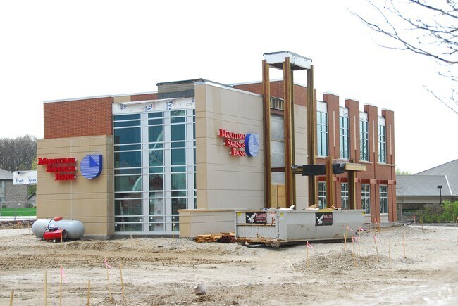
S74w17095 Janesville Rd, Muskego, WI 53150


NEARBY LISTINGS FOR SALE OR LEASE
Property Detail
S74w17095 Janesville Rd
Milwaukee-Waukesha-West Allis, WI
Certified Surv Map 5319
MSKC-2199-999-002
PARCEL 1 CERT SURV 5319 VOL 42/692 REC AS DOC# 1449056 PT SW 1/4 OF NW 1/4 & NW 1/4 OF SW 1/4 SEC 10 T5N R20E :: DOC# 3894609
Commercialnec
Waukesha
X
Wisconsin
55133C0342H
1
2024
1.09 AC
2024
SE/Muskego
201703
Milwaukee/Madison
DEMOGRAPHICS near S74w17095 Janesville Rd
1 Mile
3 Mile
5 Mile
2024 Total Population
4,277
22,569
62,876
2029 Population
4,272
22,866
63,580
Pop Growth 2024-2029
(0.12%)
+ 1.32%
+ 1.12%
Average Age
45
44
44
2024 Total Households
1,731
8,828
25,169
HH Growth 2024-2029
(0.17%)
+ 1.26%
+ 0.99%
Median Household Inc
$98,218
$98,222
$100,970
Avg Household Size
2.40
2.50
2.50
2024 Avg HH Vehicles
2.00
2.00
2.00
Median Home Value
$354,924
$355,456
$336,093
Median Year Built
1985
1980
1980
Nearby Places
Map Layers
Map Styles
 Street
 Aerial
- Restaurants
- Banks
- Shops
- Fitness
- Groceries
PUBLIC TRANSPORTATION
AIRPORT
General Mitchell International
DRIVE
WALK
Distance
General Mitchell International
27 min
13.6 mi
Freight Ports
Port Milwaukee
DRIVE
WALK
Distance
Port Milwaukee
26 min
15.5 mi
SALE & LEASE HISTORY
LISTING DATE
SALE/LEASE

Jun 04, 2021
For Lease
Nearby Properties
Address
Land Use
TOTAL SIZE
Lot Size
Zoning
Address
Land Use
TOTAL SIZE
Lot Size
Zoning
464,768 SF
34.90 AC
M1
Address
Land Use
TOTAL SIZE
Lot Size
Zoning
17.68 AC
Address
Land Use
TOTAL SIZE
Lot Size
Zoning
33.26 AC
Address
Land Use
TOTAL SIZE
Lot Size
Zoning
Address
Land Use
TOTAL SIZE
Lot Size
Zoning
15.24 AC
Address
Land Use
TOTAL SIZE
Lot Size
Zoning
154,897 SF
17.51 AC
O2
Address
Land Use
TOTAL SIZE
Lot Size
Zoning
217,472 SF
21.27 AC
M1
Address
Land Use
TOTAL SIZE
Lot Size
Zoning
171,506 SF
11.85 AC
M1
Address
Land Use
TOTAL SIZE
Lot Size
Zoning
164,440 SF
11.63 AC
M1
Address
Land Use
TOTAL SIZE
Lot Size
Zoning
93,776 SF
7.94 AC
M1
Address
Land Use
TOTAL SIZE
Lot Size
Zoning
Address
Land Use
TOTAL SIZE
Lot Size
Zoning
56,052 SF
8.46 AC
O2
Address
Land Use
TOTAL SIZE
Lot Size
Zoning
122,604 SF
11.12 AC
M1
Address
Land Use
TOTAL SIZE
Lot Size
Zoning
15.88 AC
Address
Land Use
TOTAL SIZE
Lot Size
Zoning
200,160 SF
11.44 AC
M1
Address
Land Use
TOTAL SIZE
Lot Size
Zoning
119,787 SF
10.44 AC
M1
Address
Land Use
TOTAL SIZE
Lot Size
Zoning
Address
Land Use
TOTAL SIZE
Lot Size
Zoning
100,939 SF
8.97 AC
M1
Address
Land Use
TOTAL SIZE
Lot Size
Zoning
Address
Land Use
TOTAL SIZE
Lot Size
Zoning
110,101 SF
8.51 AC
M1
Address
Land Use
TOTAL SIZE
Lot Size
Zoning
Address
Land Use
TOTAL SIZE
Lot Size
Zoning
Address
Land Use
TOTAL SIZE
Lot Size
Zoning
Address
Land Use
TOTAL SIZE
Lot Size
Zoning
132,478 SF
13.29 AC
M1
Address
Land Use
TOTAL SIZE
Lot Size
Zoning
5.14 AC
Address
Land Use
TOTAL SIZE
Lot Size
Zoning
79,844 SF
5.90 AC
M1
Address
Land Use
TOTAL SIZE
Lot Size
Zoning
7.44 AC
Address
Land Use
TOTAL SIZE
Lot Size
Zoning
69,304 SF
7.28 AC
M1
Address
Land Use
TOTAL SIZE
Lot Size
Zoning
5.68 AC
M1
Address
Land Use
TOTAL SIZE
Lot Size
Zoning
8.59 AC
M1
The World's #1 Commercial Real Estate Marketplace
Connect with us
© 2025 CoStar Group
The information above has been obtained from sources believed reliable. While we do not doubt its accuracy we have not verified it and make no guarantee, warranty or representation about it. It is your responsibility to independently confirm its accuracy and completeness. Any projections, opinions, assumptions, or estimates used are for example only and do not represent the current or future performance of the property. The value of this transaction to you depends on tax and other factors which should be evaluated by your tax, financial, and legal advisors. You and your advisors should conduct a careful, independent investigation of the property to determine to your satisfaction the suitability of the property for your needs.