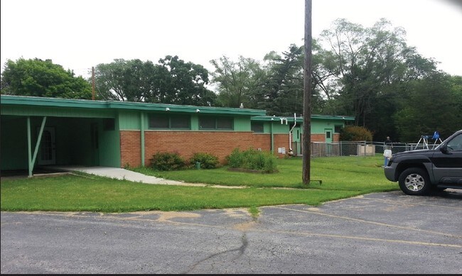
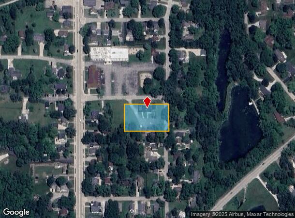
Property Record
S89w22915 Maple Ave, Big Bend, WI 53103
NEARBY LISTINGS FOR SALE OR LEASE
-
-
View all Big Bend listings for sale on LoopNet.com
Property Detail
S89w22915 Maple Ave
Milwaukee-Waukesha-West Allis, WI
Certified Surv Map 6282
BBV-2110-951
PT NW1/4 SEC 24 T5N R19E; COM 676.50 FT N & 371.25 FT E OF W1/4 POST; N 160 FT; E 156.75 FT; S 160 FT; W 156.75 FT TO BGN :: ALSO COM 676.50 FT N & 264 FT E OF W1/4 POST; N 160 FT; E 107.25 FT; S 160 FT; W 107.25 FT TO BGN :: DOC# 4171664
Commercialnec
Waukesha
X
Wisconsin
55133C0339H
5
2024
0.97 AC
2024
SE/Muskego
202002
Milwaukee/Madison
DEMOGRAPHICS near S89w22915 Maple Ave
1 Mile
3 Mile
5 Mile
2024 Total Population
1,234
7,692
32,237
2029 Population
1,273
7,892
32,667
Pop Growth 2024-2029
+ 3.16%
+ 2.60%
+ 1.33%
Average Age
44
43
44
2024 Total Households
501
2,894
12,460
HH Growth 2024-2029
+ 3.19%
+ 2.59%
+ 1.27%
Median Household Inc
$115,655
$109,422
$106,858
Avg Household Size
2.50
2.60
2.60
2024 Avg HH Vehicles
3.00
2.00
2.00
Median Home Value
$292,499
$369,220
$370,572
Median Year Built
1964
1983
1981
Nearby Places
Map Layers
Map Styles
 Street
 Aerial
- Restaurants
- Banks
- Shops
- Fitness
- Groceries
PUBLIC TRANSPORTATION
AIRPORT
General Mitchell International
DRIVE
WALK
Distance
General Mitchell International
31 min
20.2 mi
Freight Ports
Port Milwaukee
DRIVE
WALK
Distance
Port Milwaukee
30 min
22.1 mi
Nearby Properties
Address
Land Use
TOTAL SIZE
Lot Size
Zoning
Address
Land Use
TOTAL SIZE
Lot Size
Zoning
Address
Land Use
TOTAL SIZE
Lot Size
Zoning
Address
Land Use
TOTAL SIZE
Lot Size
Zoning
Address
Land Use
TOTAL SIZE
Lot Size
Zoning
Address
Land Use
TOTAL SIZE
Lot Size
Zoning
Address
Land Use
TOTAL SIZE
Lot Size
Zoning
Address
Land Use
TOTAL SIZE
Lot Size
Zoning
190.33 AC
Address
Land Use
TOTAL SIZE
Lot Size
Zoning
5.27 AC
Address
Land Use
TOTAL SIZE
Lot Size
Zoning
2.62 AC
Address
Land Use
TOTAL SIZE
Lot Size
Zoning
4.28 AC
Address
Land Use
TOTAL SIZE
Lot Size
Zoning
Address
Land Use
TOTAL SIZE
Lot Size
Zoning
46.16 AC
Address
Land Use
TOTAL SIZE
Lot Size
Zoning
2.68 AC
Address
Land Use
TOTAL SIZE
Lot Size
Zoning
Address
Land Use
TOTAL SIZE
Lot Size
Zoning
16.71 AC
Address
Land Use
TOTAL SIZE
Lot Size
Zoning
56.31 AC
Address
Land Use
TOTAL SIZE
Lot Size
Zoning
Address
Land Use
TOTAL SIZE
Lot Size
Zoning
Address
Land Use
TOTAL SIZE
Lot Size
Zoning
Address
Land Use
TOTAL SIZE
Lot Size
Zoning
Address
Land Use
TOTAL SIZE
Lot Size
Zoning
Address
Land Use
TOTAL SIZE
Lot Size
Zoning
Address
Land Use
TOTAL SIZE
Lot Size
Zoning
Address
Land Use
TOTAL SIZE
Lot Size
Zoning
Address
Land Use
TOTAL SIZE
Lot Size
Zoning
Address
Land Use
TOTAL SIZE
Lot Size
Zoning
Address
Land Use
TOTAL SIZE
Lot Size
Zoning
Address
Land Use
TOTAL SIZE
Lot Size
Zoning
Address
Land Use
TOTAL SIZE
Lot Size
Zoning
1.70 AC
Address
Land Use
TOTAL SIZE
Lot Size
Zoning
1.96 AC
The World's #1 Commercial Real Estate Marketplace
Connect with us
© 2025 CoStar Group
The information above has been obtained from sources believed reliable. While we do not doubt its accuracy we have not verified it and make no guarantee, warranty or representation about it. It is your responsibility to independently confirm its accuracy and completeness. Any projections, opinions, assumptions, or estimates used are for example only and do not represent the current or future performance of the property. The value of this transaction to you depends on tax and other factors which should be evaluated by your tax, financial, and legal advisors. You and your advisors should conduct a careful, independent investigation of the property to determine to your satisfaction the suitability of the property for your needs.