Property Record
Saemann Rd, Chesterton, IN 46304
Save to a Folder
{{folder.Name}}
{{folder.ListingIds.length}} Properties
{{folder.ListingIds.length}} Property
Create a New Folder
Property Detail
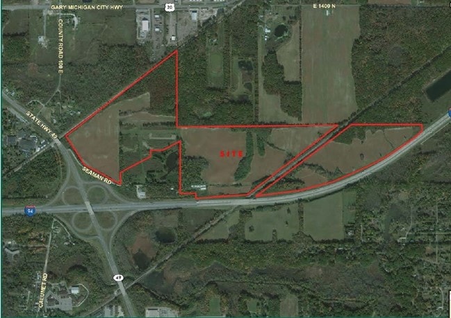
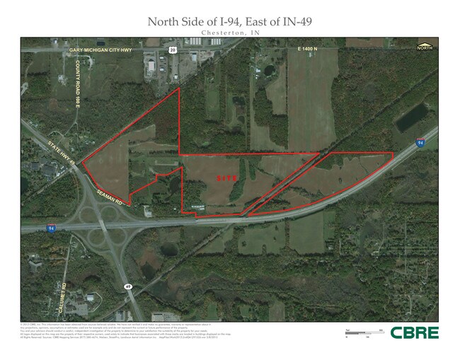
Saemann Rd
Chicago-Naperville-Elgin, IL-IN
PARC IN SE N OF I-94 DESC DR484 P590 30-37-5 2.87A
64-04-30-400-001.000-021
PORTER
Agriculturalland
Indiana
B and X Area of moderate flood hazard, usually the area between the limits of the 100-year and 500-year floods.
85.04 AC
2024
Porter County
2025
Chicago
050203
NEARBY LISTINGS FOR SALE OR LEASE
DEMOGRAPHICS near Saemann Rd
1 mile
3 mile
5 mile
2025 Total Population
958
19,761
27,557
2030 Population
967
20,019
27,966
Pop Growth 2025-2030
+ 0.94%
+ 1.31%
+ 1.48%
Average Age
44
42
42
2025 Total Households
367
7,932
10,875
HH Growth 2025-2030
+ 0.82%
+ 1.19%
+ 1.35%
Median Household Inc
$83,088
$80,800
$82,622
Avg Household Size
2.50
2.40
2.50
2025 Avg HH Vehicles
2.00
2.00
2.00
Median Home Value
$305,000
$294,645
$307,221
Median Year Built
1973
1977
1982
Nearby Places
Map Layers
Map Styles
 Street
 Aerial
Layers
 Traffic
 Biking
Places
Listings with unknown addresses are not visible on the map
- Restaurants
- Banks
- Shops
- Fitness
- Groceries
PUBLIC TRANSPORTATION
COMMUTER RAIL
Dune Park (Chesterton) Station (South Shore Line - Northern Indiana Commuter Transportation District (South Shore Line))
Drive
Walk
Distance
Dune Park (Chesterton) Station (South Shore Line - Northern Indiana Commuter Transportation District (South Shore Line))
4 min
2.4 mi
Beverly Shores (South Shore Line - Northern Indiana Commuter Transportation District (South Shore Line))
Drive
Walk
Distance
Beverly Shores (South Shore Line - Northern Indiana Commuter Transportation District (South Shore Line))
10 min
6.1 mi
Freight Ports
Port Milwaukee
Drive
Walk
Distance
Port Milwaukee
164 min
132.7 mi
SALE & LEASE HISTORY
LISTING DATE
SALE/LEASE

Sep 24, 2016
For Sale
Sep 24, 2016
For Sale
Feb 14, 2017
For Sale
Nearby Properties
Address
Land Use
TOTAL SIZE
Lot Size
Zoning
Address
Land Use
TOTAL SIZE
Lot Size
Zoning
159,404 SF
15.84 AC
Address
Land Use
TOTAL SIZE
Lot Size
Zoning
174,766 SF
17.47 AC
Address
Land Use
TOTAL SIZE
Lot Size
Zoning
109,131 SF
7.38 AC
Address
Land Use
TOTAL SIZE
Lot Size
Zoning
108,528 SF
10.28 AC
Address
Land Use
TOTAL SIZE
Lot Size
Zoning
164,280 SF
46.39 AC
Address
Land Use
TOTAL SIZE
Lot Size
Zoning
61,248 SF
6.77 AC
Address
Land Use
TOTAL SIZE
Lot Size
Zoning
52,765 SF
5.92 AC
Address
Land Use
TOTAL SIZE
Lot Size
Zoning
61,873 SF
8 AC
Address
Land Use
TOTAL SIZE
Lot Size
Zoning
114,061 SF
6.26 AC
Address
Land Use
TOTAL SIZE
Lot Size
Zoning
38,337 SF
10 AC
Address
Land Use
TOTAL SIZE
Lot Size
Zoning
62,401 SF
9.83 AC
Address
Land Use
TOTAL SIZE
Lot Size
Zoning
90,396 SF
6.82 AC
Address
Land Use
TOTAL SIZE
Lot Size
Zoning
62,261 SF
5.69 AC
Address
Land Use
TOTAL SIZE
Lot Size
Zoning
42.89 AC
Address
Land Use
TOTAL SIZE
Lot Size
Zoning
26,090 SF
5.68 AC
Address
Land Use
TOTAL SIZE
Lot Size
Zoning
60,861 SF
5.94 AC
Address
Land Use
TOTAL SIZE
Lot Size
Zoning
21,203 SF
30.03 AC
Address
Land Use
TOTAL SIZE
Lot Size
Zoning
20,400 SF
7.39 AC
Address
Land Use
TOTAL SIZE
Lot Size
Zoning
63,357 SF
7.10 AC
Address
Land Use
TOTAL SIZE
Lot Size
Zoning
56,807 SF
9.10 AC
Address
Land Use
TOTAL SIZE
Lot Size
Zoning
419,212 SF
78.36 AC
Address
Land Use
TOTAL SIZE
Lot Size
Zoning
25,646 SF
2.57 AC
Address
Land Use
TOTAL SIZE
Lot Size
Zoning
19,896 SF
2.09 AC
Address
Land Use
TOTAL SIZE
Lot Size
Zoning
28,740 SF
12.45 AC
Address
Land Use
TOTAL SIZE
Lot Size
Zoning
3,682 SF
17.23 AC
Address
Land Use
TOTAL SIZE
Lot Size
Zoning
14,030 SF
1.03 AC
Address
Land Use
TOTAL SIZE
Lot Size
Zoning
36,288 SF
4.59 AC
Address
Land Use
TOTAL SIZE
Lot Size
Zoning
42,159 SF
4.74 AC
Address
Land Use
TOTAL SIZE
Lot Size
Zoning
31,780 SF
1.76 AC
Address
Land Use
TOTAL SIZE
Lot Size
Zoning
36,288 SF
2.61 AC
The World's #1 Commercial Real Estate Marketplace
Connect with us
© 2026 CoStar Group
The information above has been obtained from sources believed reliable. While we do not doubt its accuracy we have not verified it and make no guarantee, warranty or representation about it. It is your responsibility to independently confirm its accuracy and completeness. Any projections, opinions, assumptions, or estimates used are for example only and do not represent the current or future performance of the property. The value of this transaction to you depends on tax and other factors which should be evaluated by your tax, financial, and legal advisors. You and your advisors should conduct a careful, independent investigation of the property to determine to your satisfaction the suitability of the property for your needs.