Property Record
Sandtown Rd, Lagrange, GA 30240

Property Detail
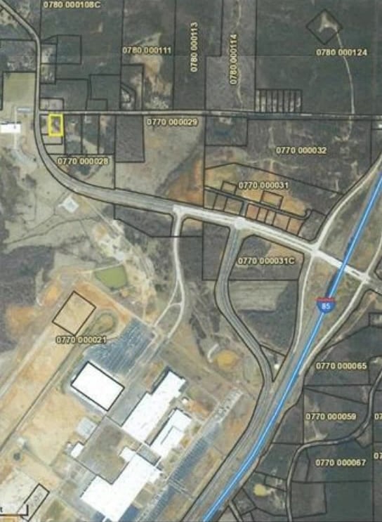
Sandtown Rd
LaGrange, GA-AL
SANDTOWN RD/LOT 1A SANDTOWN CORNER S/D
077-0-000-028E
TROUP
Commercialacreage
Georgia
17-CGN
1a
B and X Area of moderate flood hazard, usually the area between the limits of the 100-year and 500-year floods.
1.20 AC
2025
Troup County
2025
Columbus GA
960300
NEARBY LISTINGS FOR SALE OR LEASE
-
-
-
-
-
No Photo
-
View all Lagrange listings for sale on LoopNet.com
DEMOGRAPHICS near Sandtown Rd
1 mile
3 mile
5 mile
2025 Total Population
313
2,268
7,758
2030 Population
324
2,346
8,004
Pop Growth 2025-2030
+ 3.51%
+ 3.44%
+ 3.17%
Average Age
40
40
41
2025 Total Households
112
844
2,988
HH Growth 2025-2030
+ 3.57%
+ 3.79%
+ 3.38%
Median Household Inc
$66,346
$65,759
$65,770
Avg Household Size
2.70
2.60
2.60
2025 Avg HH Vehicles
2.00
2.00
2.00
Median Home Value
$225,000
$218,406
$206,365
Median Year Built
1991
1989
1987
Nearby Places
Map Layers
Map Styles
 Street
 Aerial
Transit
 Traffic
 Biking
Places
Listings with unknown addresses are not visible on the map
- Restaurants
- Banks
- Shops
- Fitness
- Groceries
PUBLIC TRANSPORTATION
AIRPORT
Columbus
Drive
Walk
Distance
Columbus
51 min
38.2 mi
SALE & LEASE HISTORY
LISTING DATE
SALE/LEASE

Mar 08, 2019
For Sale
Jun 07, 2017
For Sale
Nearby Properties
Address
Land Use
TOTAL SIZE
Lot Size
Zoning
Address
Land Use
TOTAL SIZE
Lot Size
Zoning
415,440 SF
1,989.06 AC
17-I-1
Address
Land Use
TOTAL SIZE
Lot Size
Zoning
Address
Land Use
TOTAL SIZE
Lot Size
Zoning
517,521 SF
27.03 AC
17-I-1
Address
Land Use
TOTAL SIZE
Lot Size
Zoning
255,952 SF
1 AC
17-I-1
Address
Land Use
TOTAL SIZE
Lot Size
Zoning
311,435 SF
1 AC
17-I-1
Address
Land Use
TOTAL SIZE
Lot Size
Zoning
307,800 SF
49.87 AC
17-MXD-1
Address
Land Use
TOTAL SIZE
Lot Size
Zoning
Address
Land Use
TOTAL SIZE
Lot Size
Zoning
426,400 SF
1 AC
17-I-1
Address
Land Use
TOTAL SIZE
Lot Size
Zoning
Address
Land Use
TOTAL SIZE
Lot Size
Zoning
88.55 AC
Address
Land Use
TOTAL SIZE
Lot Size
Zoning
88.55 AC
Address
Land Use
TOTAL SIZE
Lot Size
Zoning
Address
Land Use
TOTAL SIZE
Lot Size
Zoning
154,930 SF
73.75 AC
01-SU-R
Address
Land Use
TOTAL SIZE
Lot Size
Zoning
132,600 SF
1 AC
Address
Land Use
TOTAL SIZE
Lot Size
Zoning
Address
Land Use
TOTAL SIZE
Lot Size
Zoning
70,000 SF
1 AC
17-I-1
Address
Land Use
TOTAL SIZE
Lot Size
Zoning
160.49 AC
17-R-1
Address
Land Use
TOTAL SIZE
Lot Size
Zoning
75,684 SF
5.28 AC
17-MXD-1
Address
Land Use
TOTAL SIZE
Lot Size
Zoning
63,804 SF
8.60 AC
17-MXD-1
Address
Land Use
TOTAL SIZE
Lot Size
Zoning
57.63 AC
01-SU-R
Address
Land Use
TOTAL SIZE
Lot Size
Zoning
62,262 SF
25 AC
01-SU-R
Address
Land Use
TOTAL SIZE
Lot Size
Zoning
Address
Land Use
TOTAL SIZE
Lot Size
Zoning
Address
Land Use
TOTAL SIZE
Lot Size
Zoning
7,310 SF
6 AC
17-CGN
Address
Land Use
TOTAL SIZE
Lot Size
Zoning
29,327 SF
1.13 AC
17-MXD-1
Address
Land Use
TOTAL SIZE
Lot Size
Zoning
117.38 AC
17-R-1
Address
Land Use
TOTAL SIZE
Lot Size
Zoning
70.58 AC
17-CGN
Address
Land Use
TOTAL SIZE
Lot Size
Zoning
22.17 AC
17-CGN
Address
Land Use
TOTAL SIZE
Lot Size
Zoning
44,375 SF
6.51 AC
17-MXD-1
Address
Land Use
TOTAL SIZE
Lot Size
Zoning
79.93 AC
17-MXD-1
The World's #1 Commercial Real Estate Marketplace
Connect with us
© 2026 CoStar Group
The information above has been obtained from sources believed reliable. While we do not doubt its accuracy we have not verified it and make no guarantee, warranty or representation about it. It is your responsibility to independently confirm its accuracy and completeness. Any projections, opinions, assumptions, or estimates used are for example only and do not represent the current or future performance of the property. The value of this transaction to you depends on tax and other factors which should be evaluated by your tax, financial, and legal advisors. You and your advisors should conduct a careful, independent investigation of the property to determine to your satisfaction the suitability of the property for your needs.