Property Record
Sandy Spring Rd, , MD


Property Detail
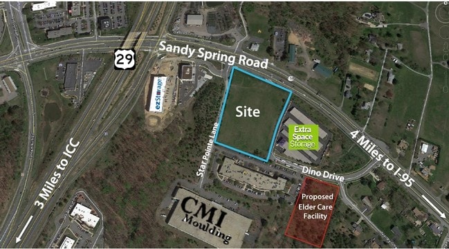
Sandy Spring Rd
05-01508192
NEW BIRMINGHAM MANOR
Vacantlandnec
MONTGOMERY
IM2.5
Maryland
B and X Area of moderate flood hazard, usually the area between the limits of the 100-year and 500-year floods.
5.12 AC
2024
North Silver Spring/Rt 29
2025
Washington, DC
701409
Washington-Arlington-Alexandria, DC-VA-MD-WV
29,600 SF
NEARBY LISTINGS FOR SALE OR LEASE
-
-
View all listings for sale on LoopNet.com
DEMOGRAPHICS near Sandy Spring Rd
1 mile
3 mile
5 mile
2024 Total Population
7,399
55,940
196,765
2029 Population
7,576
57,126
200,385
Pop Growth 2024-2029
+ 2.39%
+ 2.12%
+ 1.84%
Average Age
39
40
40
2024 Total Households
2,318
19,442
69,457
HH Growth 2024-2029
+ 2.29%
+ 2.17%
+ 1.84%
Median Household Inc
$125,615
$117,816
$111,428
Avg Household Size
3.10
2.80
2.80
2024 Avg HH Vehicles
2.00
2.00
2.00
Median Home Value
$470,344
$526,270
$535,629
Median Year Built
1986
1985
1984
Nearby Places
Map Layers
Map Styles
 Street
 Aerial
Transit
 Traffic
 Biking
Places
Listings with unknown addresses are not visible on the map
- Restaurants
- Banks
- Shops
- Fitness
- Groceries
PUBLIC TRANSPORTATION
COMMUTER RAIL
Laurel (Camden Line - Maryland Area Regional Commuter Trains (The MARC))
Drive
Walk
Distance
Laurel (Camden Line - Maryland Area Regional Commuter Trains (The MARC))
11 min
5.4 mi
Muirkirk (Camden Line - Maryland Area Regional Commuter Trains (The MARC))
Drive
Walk
Distance
Muirkirk (Camden Line - Maryland Area Regional Commuter Trains (The MARC))
10 min
5.5 mi
AIRPORT
Baltimore/Washington International Thurgood Marshall
Drive
Walk
Distance
Baltimore/Washington International Thurgood Marshall
24 min
20.2 mi
Ronald Reagan Washington Ntl
Drive
Walk
Distance
Ronald Reagan Washington Ntl
38 min
29.6 mi
Freight Ports
Port of Baltimore
Drive
Walk
Distance
Port of Baltimore
1 min
20.6 mi
SALE & LEASE HISTORY
LISTING DATE
SALE/LEASE

Feb 17, 2017
For Sale
Nearby Properties
Address
Land Use
TOTAL SIZE
Lot Size
Zoning
Address
Land Use
TOTAL SIZE
Lot Size
Zoning
393,970 SF
44 AC
RR
Address
Land Use
TOTAL SIZE
Lot Size
Zoning
218,406 SF
26.80 AC
LAUR
Address
Land Use
TOTAL SIZE
Lot Size
Zoning
531,312 SF
25.70 AC
R30
Address
Land Use
TOTAL SIZE
Lot Size
Zoning
390,986 SF
16.87 AC
LAUR
Address
Land Use
TOTAL SIZE
Lot Size
Zoning
559,944 SF
11.89 AC
IE
Address
Land Use
TOTAL SIZE
Lot Size
Zoning
482,799 SF
17.79 AC
R30
Address
Land Use
TOTAL SIZE
Lot Size
Zoning
166,410 SF
26.25 AC
CRT1.
Address
Land Use
TOTAL SIZE
Lot Size
Zoning
310,052 SF
9.63 AC
R20
Address
Land Use
TOTAL SIZE
Lot Size
Zoning
222,345 SF
14.21 AC
R30
Address
Land Use
TOTAL SIZE
Lot Size
Zoning
235,616 SF
12.81 AC
R30
Address
Land Use
TOTAL SIZE
Lot Size
Zoning
4,380 SF
17.89 AC
CRT22
Address
Land Use
TOTAL SIZE
Lot Size
Zoning
456,896 SF
8.96 AC
R20
Address
Land Use
TOTAL SIZE
Lot Size
Zoning
239,072 SF
10.41 AC
R20
Address
Land Use
TOTAL SIZE
Lot Size
Zoning
177,712 SF
13.89 AC
GR1.5
Address
Land Use
TOTAL SIZE
Lot Size
Zoning
362,438 SF
39.95 AC
IE
Address
Land Use
TOTAL SIZE
Lot Size
Zoning
154,775 SF
33.38 AC
R200
Address
Land Use
TOTAL SIZE
Lot Size
Zoning
195,369 SF
9.72 AC
R20
Address
Land Use
TOTAL SIZE
Lot Size
Zoning
202,191 SF
7.70 AC
R30
Address
Land Use
TOTAL SIZE
Lot Size
Zoning
19.17 AC
IE
Address
Land Use
TOTAL SIZE
Lot Size
Zoning
242,468 SF
17.77 AC
R30
Address
Land Use
TOTAL SIZE
Lot Size
Zoning
115,000 SF
10.14 AC
RE1
Address
Land Use
TOTAL SIZE
Lot Size
Zoning
141,492 SF
7.96 AC
R20
Address
Land Use
TOTAL SIZE
Lot Size
Zoning
127,803 SF
2.91 AC
EOF07
Address
Land Use
TOTAL SIZE
Lot Size
Zoning
89,612 SF
30.76 AC
RRDEO
Address
Land Use
TOTAL SIZE
Lot Size
Zoning
94,545 SF
30.85 AC
RC
Address
Land Use
TOTAL SIZE
Lot Size
Zoning
57,749 SF
4.98 AC
GR1.5
Address
Land Use
TOTAL SIZE
Lot Size
Zoning
92,227 SF
6.51 AC
R200
Address
Land Use
TOTAL SIZE
Lot Size
Zoning
75,000 SF
2.83 AC
RRMXD
Address
Land Use
TOTAL SIZE
Lot Size
Zoning
104,796 SF
3.49 AC
MXD3
Address
Land Use
TOTAL SIZE
Lot Size
Zoning
95,600 SF
3.91 AC
IM2.5
The World's #1 Commercial Real Estate Marketplace
Connect with us
© 2026 CoStar Group
The information above has been obtained from sources believed reliable. While we do not doubt its accuracy we have not verified it and make no guarantee, warranty or representation about it. It is your responsibility to independently confirm its accuracy and completeness. Any projections, opinions, assumptions, or estimates used are for example only and do not represent the current or future performance of the property. The value of this transaction to you depends on tax and other factors which should be evaluated by your tax, financial, and legal advisors. You and your advisors should conduct a careful, independent investigation of the property to determine to your satisfaction the suitability of the property for your needs.