Property Record
Sanford Dr, Morganton, NC 28655
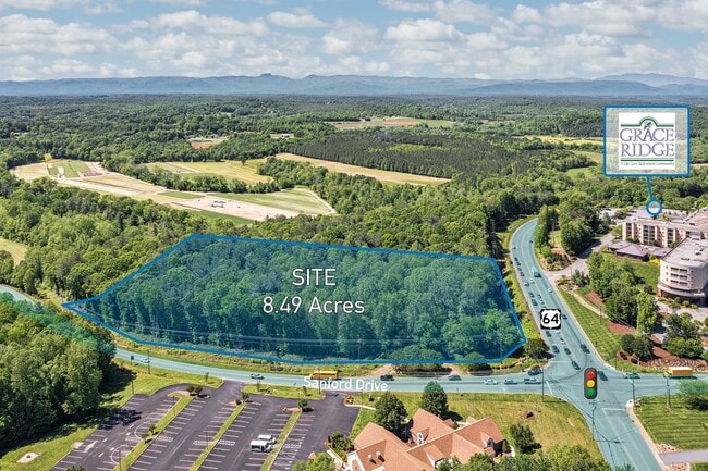

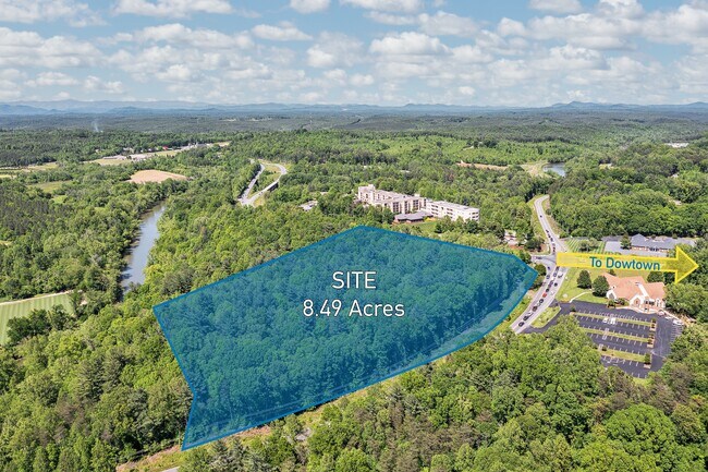
This Property Is For Sale
Property Detail
Sanford Dr
6028
SANFORD DR MORGANTON, NC 28655
Vacantlandnec
BURKE
MEDIUM INT
North Carolina
C and X Area of minimal flood hazard, usually depicted on FIRMs as above the 500-year flood level.
8.04 AC
2025
Burke County
2025
Charlotte
021400
Hickory-Lenoir-Morganton, NC
NEARBY LISTINGS FOR SALE OR LEASE
DEMOGRAPHICS near Sanford Dr
1 mile
3 mile
5 mile
2025 Total Population
3,383
17,386
32,157
2030 Population
3,415
17,459
32,392
Pop Growth 2025-2030
+ 0.95%
+ 0.42%
+ 0.73%
Average Age
42
42
43
2025 Total Households
1,341
6,956
12,878
HH Growth 2025-2030
+ 1.04%
+ 0.52%
+ 0.85%
Median Household Inc
$40,786
$50,573
$52,298
Avg Household Size
2.40
2.40
2.40
2025 Avg HH Vehicles
2.00
2.00
2.00
Median Home Value
$204,570
$252,005
$231,667
Median Year Built
1973
1971
1975
Nearby Places
Map Layers
Map Styles
 Street
 Aerial
Transit
 Traffic
 Biking
Places
Listings with unknown addresses are not visible on the map
- Restaurants
- Banks
- Shops
- Fitness
- Groceries
Nearby Properties
Address
Land Use
TOTAL SIZE
Lot Size
Zoning
Address
Land Use
TOTAL SIZE
Lot Size
Zoning
STATE INST
Address
Land Use
TOTAL SIZE
Lot Size
Zoning
89,004 SF
STATE INST
Address
Land Use
TOTAL SIZE
Lot Size
Zoning
32,074 SF
HIGH INTEN
Address
Land Use
TOTAL SIZE
Lot Size
Zoning
6,912 SF
24.27 AC
HIGH INTEN
Address
Land Use
TOTAL SIZE
Lot Size
Zoning
146,058 SF
52.85 AC
MEDIUM INT
Address
Land Use
TOTAL SIZE
Lot Size
Zoning
MEDIUM INT
Address
Land Use
TOTAL SIZE
Lot Size
Zoning
LOW INTENS
Address
Land Use
TOTAL SIZE
Lot Size
Zoning
23,970 SF
33.98 AC
CONDITIONA
Address
Land Use
TOTAL SIZE
Lot Size
Zoning
MEDIUM INT
Address
Land Use
TOTAL SIZE
Lot Size
Zoning
73,530 SF
Address
Land Use
TOTAL SIZE
Lot Size
Zoning
185,929 SF
32.01 AC
CONDITIONA
Address
Land Use
TOTAL SIZE
Lot Size
Zoning
2,400 SF
26.53 AC
MEDIUM INT
Address
Land Use
TOTAL SIZE
Lot Size
Zoning
6,052 SF
13.04 AC
MEDIUM INT
Address
Land Use
TOTAL SIZE
Lot Size
Zoning
250,292 SF
53.11 AC
EXCLUSIVE
Address
Land Use
TOTAL SIZE
Lot Size
Zoning
2,160 SF
12.81 AC
MEDIUM INT
Address
Land Use
TOTAL SIZE
Lot Size
Zoning
6,402 SF
14.14 AC
MEDIUM INT
Address
Land Use
TOTAL SIZE
Lot Size
Zoning
52,977 SF
1.90 AC
MEDIUM INT
Address
Land Use
TOTAL SIZE
Lot Size
Zoning
32,698 SF
23 AC
MEDIUM INT
Address
Land Use
TOTAL SIZE
Lot Size
Zoning
HIGH INTEN
Address
Land Use
TOTAL SIZE
Lot Size
Zoning
58,998 SF
LOW INTENS
Address
Land Use
TOTAL SIZE
Lot Size
Zoning
71,060 SF
3.10 AC
HIGH INTEN
Address
Land Use
TOTAL SIZE
Lot Size
Zoning
40,056 SF
13.80 AC
CONDITIONA
Address
Land Use
TOTAL SIZE
Lot Size
Zoning
65,175 SF
13.48 AC
CONDITIONA
Address
Land Use
TOTAL SIZE
Lot Size
Zoning
20.08 AC
MEDIUM INT
Address
Land Use
TOTAL SIZE
Lot Size
Zoning
28,405 SF
CENTRAL BU
Address
Land Use
TOTAL SIZE
Lot Size
Zoning
46,334 SF
CENTRAL BU
Address
Land Use
TOTAL SIZE
Lot Size
Zoning
109,902 SF
10.97 AC
EXC IND DI
Address
Land Use
TOTAL SIZE
Lot Size
Zoning
24,361 SF
CENTRAL BU
Address
Land Use
TOTAL SIZE
Lot Size
Zoning
3,440 SF
11.03 AC
MEDIUM INT
Address
Land Use
TOTAL SIZE
Lot Size
Zoning
52,468 SF
8.31 AC
HIGH INTEN
The World's #1 Commercial Real Estate Marketplace
Connect with us
© 2026 CoStar Group
The information above has been obtained from sources believed reliable. While we do not doubt its accuracy we have not verified it and make no guarantee, warranty or representation about it. It is your responsibility to independently confirm its accuracy and completeness. Any projections, opinions, assumptions, or estimates used are for example only and do not represent the current or future performance of the property. The value of this transaction to you depends on tax and other factors which should be evaluated by your tax, financial, and legal advisors. You and your advisors should conduct a careful, independent investigation of the property to determine to your satisfaction the suitability of the property for your needs.