Property Record
Scarecorn Creek Rd W, Jasper, GA 30143

NEARBY LISTINGS FOR SALE OR LEASE
-
-
View all Jasper listings for sale on LoopNet.com
Property Detail
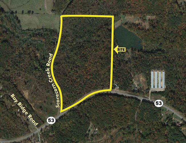
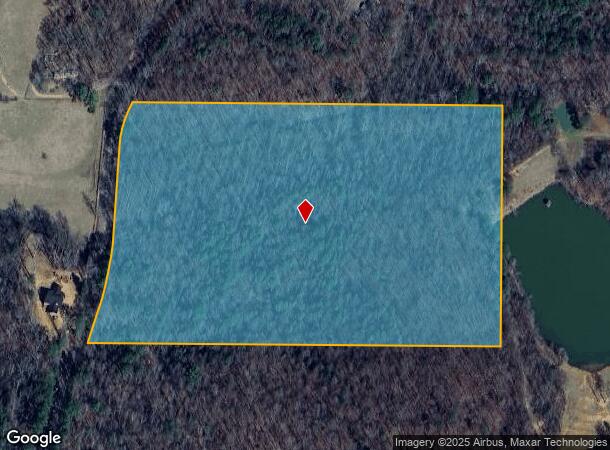
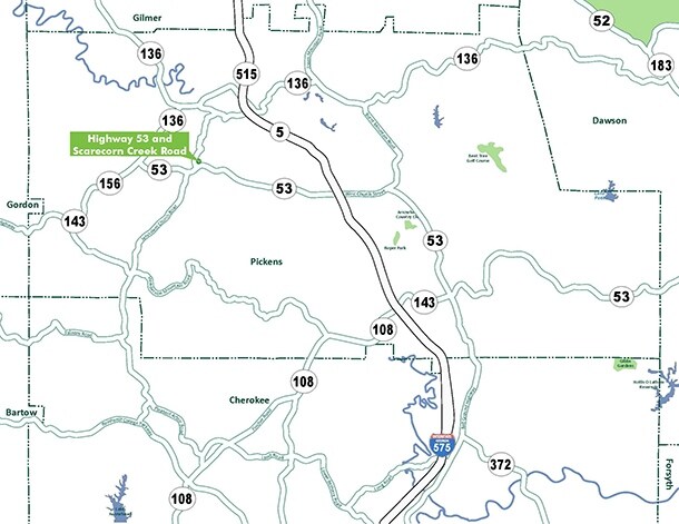
Scarecorn Creek Rd W
Atlanta-Sandy Springs-Roswell, GA
Rural
032-000-062-000
DIST12 LL56,53 22.84AC TRACT A
Residentialacreage
Pickens
A
Georgia
13057C0050E
22.84 AC
2024
Pickens County
2024
Atlanta
050202
DEMOGRAPHICS near Scarecorn Creek Rd W
1 Mile
3 Mile
5 Mile
2024 Total Population
395
3,439
9,375
2029 Population
442
3,857
10,533
Pop Growth 2024-2029
+ 11.90%
+ 12.15%
+ 12.35%
Average Age
40
41
42
2024 Total Households
141
1,240
3,430
HH Growth 2024-2029
+ 12.06%
+ 12.02%
+ 12.16%
Median Household Inc
$67,105
$67,449
$64,596
Avg Household Size
2.70
2.70
2.60
2024 Avg HH Vehicles
2.00
2.00
2.00
Median Home Value
$243,103
$245,220
$247,875
Median Year Built
1996
1996
1995
Nearby Places
Map Layers
Map Styles
 Street
 Aerial
- Restaurants
- Banks
- Shops
- Fitness
- Groceries
SALE & LEASE HISTORY
LISTING DATE
SALE/LEASE

Sep 24, 2016
For Sale
Oct 02, 2017
For Sale
Nearby Properties
Address
Land Use
TOTAL SIZE
Lot Size
Zoning
Address
Land Use
TOTAL SIZE
Lot Size
Zoning
74,652 SF
31.20 AC
HB
Address
Land Use
TOTAL SIZE
Lot Size
Zoning
3,040 SF
7.15 AC
HB
Address
Land Use
TOTAL SIZE
Lot Size
Zoning
538.93 AC
AG
Address
Land Use
TOTAL SIZE
Lot Size
Zoning
153.92 AC
RR
Address
Land Use
TOTAL SIZE
Lot Size
Zoning
19,574 SF
35.16 AC
AG
Address
Land Use
TOTAL SIZE
Lot Size
Zoning
37,345 SF
39.82 AC
I
Address
Land Use
TOTAL SIZE
Lot Size
Zoning
26 AC
AG
Address
Land Use
TOTAL SIZE
Lot Size
Zoning
313.50 AC
C-2
Address
Land Use
TOTAL SIZE
Lot Size
Zoning
12,934 SF
5.20 AC
HB
Address
Land Use
TOTAL SIZE
Lot Size
Zoning
15,000 SF
7.41 AC
HB
Address
Land Use
TOTAL SIZE
Lot Size
Zoning
426.77 AC
AG
Address
Land Use
TOTAL SIZE
Lot Size
Zoning
179.50 AC
AG
Address
Land Use
TOTAL SIZE
Lot Size
Zoning
185.58 AC
C-2
Address
Land Use
TOTAL SIZE
Lot Size
Zoning
158.61 AC
AG
Address
Land Use
TOTAL SIZE
Lot Size
Zoning
35.12 AC
AG
Address
Land Use
TOTAL SIZE
Lot Size
Zoning
108.90 AC
NC
Address
Land Use
TOTAL SIZE
Lot Size
Zoning
86.72 AC
RR
Address
Land Use
TOTAL SIZE
Lot Size
Zoning
2,400 SF
0.90 AC
C-2
Address
Land Use
TOTAL SIZE
Lot Size
Zoning
34.54 AC
AG
Address
Land Use
TOTAL SIZE
Lot Size
Zoning
107 AC
NC
Address
Land Use
TOTAL SIZE
Lot Size
Zoning
164.87 AC
C-2
Address
Land Use
TOTAL SIZE
Lot Size
Zoning
77.78 AC
C-2
Address
Land Use
TOTAL SIZE
Lot Size
Zoning
42.66 AC
NC
Address
Land Use
TOTAL SIZE
Lot Size
Zoning
51.57 AC
AG
Address
Land Use
TOTAL SIZE
Lot Size
Zoning
4,260 SF
1.17 AC
C-2
Address
Land Use
TOTAL SIZE
Lot Size
Zoning
3,400 SF
1.16 AC
HB
Address
Land Use
TOTAL SIZE
Lot Size
Zoning
46.51 AC
HB
Address
Land Use
TOTAL SIZE
Lot Size
Zoning
46.76 AC
AG
Address
Land Use
TOTAL SIZE
Lot Size
Zoning
5,520 SF
3.62 AC
AG
Address
Land Use
TOTAL SIZE
Lot Size
Zoning
26.14 AC
AG
The World's #1 Commercial Real Estate Marketplace
Connect with us
© 2025 CoStar Group
The information above has been obtained from sources believed reliable. While we do not doubt its accuracy we have not verified it and make no guarantee, warranty or representation about it. It is your responsibility to independently confirm its accuracy and completeness. Any projections, opinions, assumptions, or estimates used are for example only and do not represent the current or future performance of the property. The value of this transaction to you depends on tax and other factors which should be evaluated by your tax, financial, and legal advisors. You and your advisors should conduct a careful, independent investigation of the property to determine to your satisfaction the suitability of the property for your needs.