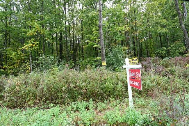
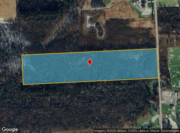
Property Record
Schepps Corners Rd, East Syracuse, NY 13057
NEARBY LISTINGS FOR SALE OR LEASE
Property Detail
Schepps Corners Rd
Syracuse, NY
FL 14
313889-039-000-0001-006-000-0000
Onondaga
Residentialacreage
New York
AE
6.000
36067C0232F
32.23 AC
2025
SE Outer Onondaga County
2024
Syracuse
014500
DEMOGRAPHICS near Schepps Corners Rd
1 Mile
3 Mile
5 Mile
2024 Total Population
297
6,954
27,136
2029 Population
290
6,842
26,627
Pop Growth 2024-2029
(2.36%)
(1.61%)
(1.88%)
Average Age
49
44
44
2024 Total Households
112
2,832
11,582
HH Growth 2024-2029
(2.68%)
(1.73%)
(2.11%)
Median Household Inc
$87,878
$73,758
$73,002
Avg Household Size
2.30
2.40
2.30
2024 Avg HH Vehicles
2.00
2.00
2.00
Median Home Value
$186,666
$156,767
$163,884
Median Year Built
1959
1967
1966
Nearby Places
- Restaurants
- Banks
- Shops
- Fitness
- Groceries
PUBLIC TRANSPORTATION
AIRPORT
Syracuse Hancock International
DRIVE
WALK
Distance
Syracuse Hancock International
18 min
10.4 mi
Freight Ports
Albany, NY Port
DRIVE
WALK
Distance
Albany, NY Port
170 min
142.6 mi
Nearby Properties
Address
Land Use
TOTAL SIZE
Lot Size
Zoning
Address
Land Use
TOTAL SIZE
Lot Size
Zoning
80,845 SF
14.04 AC
06 - INDUS
Address
Land Use
TOTAL SIZE
Lot Size
Zoning
116,580 SF
18.46 AC
06 - INDUS
Address
Land Use
TOTAL SIZE
Lot Size
Zoning
174,750 SF
10.40 AC
06 - INDUS
Address
Land Use
TOTAL SIZE
Lot Size
Zoning
104,400 SF
12.84 AC
06 - INDUS
Address
Land Use
TOTAL SIZE
Lot Size
Zoning
157,497 SF
14.56 AC
06 - INDUS
Address
Land Use
TOTAL SIZE
Lot Size
Zoning
145,588 SF
75.45 AC
RA
Address
Land Use
TOTAL SIZE
Lot Size
Zoning
5.39 AC
06 - INDUS
Address
Land Use
TOTAL SIZE
Lot Size
Zoning
141,151 SF
20.23 AC
06 - INDUS
Address
Land Use
TOTAL SIZE
Lot Size
Zoning
89,985 SF
11.37 AC
06 - INDUS
Address
Land Use
TOTAL SIZE
Lot Size
Zoning
150,216 SF
50.42 AC
RA
Address
Land Use
TOTAL SIZE
Lot Size
Zoning
70,668 SF
5.35 AC
05 - COMME
Address
Land Use
TOTAL SIZE
Lot Size
Zoning
69,910 SF
16.01 AC
06 - INDUS
Address
Land Use
TOTAL SIZE
Lot Size
Zoning
3,000 SF
75.84 AC
C
Address
Land Use
TOTAL SIZE
Lot Size
Zoning
49,160 SF
7.23 AC
06 - INDUS
Address
Land Use
TOTAL SIZE
Lot Size
Zoning
1.86 AC
C
Address
Land Use
TOTAL SIZE
Lot Size
Zoning
68.78 AC
C
Address
Land Use
TOTAL SIZE
Lot Size
Zoning
15,040 SF
9.89 AC
IND
Address
Land Use
TOTAL SIZE
Lot Size
Zoning
37.36 AC
RA
Address
Land Use
TOTAL SIZE
Lot Size
Zoning
33.18 AC
C
Address
Land Use
TOTAL SIZE
Lot Size
Zoning
70,364 SF
92.06 AC
AG
Address
Land Use
TOTAL SIZE
Lot Size
Zoning
4,200 SF
25.34 AC
C
Address
Land Use
TOTAL SIZE
Lot Size
Zoning
23.21 AC
C
Address
Land Use
TOTAL SIZE
Lot Size
Zoning
54,386 SF
9.45 AC
C
Address
Land Use
TOTAL SIZE
Lot Size
Zoning
65.19 AC
C
Address
Land Use
TOTAL SIZE
Lot Size
Zoning
20.28 AC
C
Address
Land Use
TOTAL SIZE
Lot Size
Zoning
38.54 AC
CB
Address
Land Use
TOTAL SIZE
Lot Size
Zoning
40,625 SF
4.81 AC
06 - INDUS
Address
Land Use
TOTAL SIZE
Lot Size
Zoning
5,772 SF
8.17 AC
RA
Address
Land Use
TOTAL SIZE
Lot Size
Zoning
33,446 SF
3.22 AC
C
Address
Land Use
TOTAL SIZE
Lot Size
Zoning
26,785 SF
5.11 AC
06 - INDUS
The World's #1 Commercial Real Estate Marketplace
Connect with us
© 2025 CoStar Group
The information above has been obtained from sources believed reliable. While we do not doubt its accuracy we have not verified it and make no guarantee, warranty or representation about it. It is your responsibility to independently confirm its accuracy and completeness. Any projections, opinions, assumptions, or estimates used are for example only and do not represent the current or future performance of the property. The value of this transaction to you depends on tax and other factors which should be evaluated by your tax, financial, and legal advisors. You and your advisors should conduct a careful, independent investigation of the property to determine to your satisfaction the suitability of the property for your needs.