Property Record
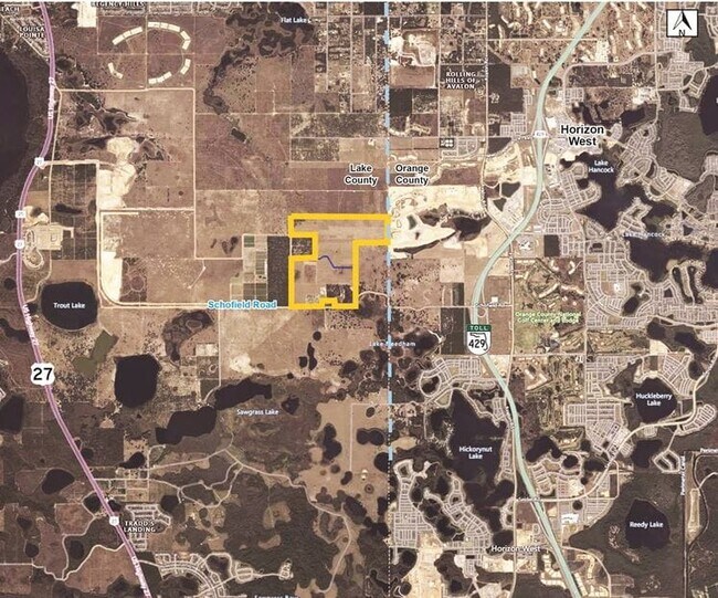
Schofield Rd, Clermont, FL 34711
Property Detail
Schofield Rd
Orlando-Kissimmee-Sanford, FL
BEGIN AT THE WEST 1/4 CORNER OF SECTION 25 TOWNSHIP 23 SOUTH RANGE 26 EAST AND RUN SOUTH 00-15-33 EAST 2641.76 FEET TO THE SOUTHWEST CORNER OF SECTION EAST 2657.96 FEET TO THE SOUTH 1/4 CORNER SOUTH 89-59-20 EAST ALONG SOUTH LINE OF SECTION 900.47 FE
25-23-26-0003-000-00800
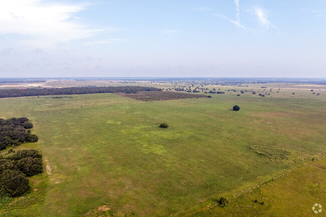
LAKE
Pasture
Florida
A
8
AE The base floodplain where base flood elevations are provided. AE Zones are now used on new format FIRMs instead of A1-A30 Zones.
191.59 AC
2024
Lake County
2026
Orlando
031315
NEARBY LISTINGS FOR SALE OR LEASE
DEMOGRAPHICS near Schofield Rd
1 mile
3 mile
5 mile
2025 Total Population
885
16,211
79,651
2030 Population
1,040
18,597
90,518
Pop Growth 2025-2030
+ 17.51%
+ 14.72%
+ 13.64%
Average Age
37
37
39
2025 Total Households
289
5,285
27,347
HH Growth 2025-2030
+ 17.65%
+ 15.04%
+ 13.91%
Median Household Inc
$191,428
$141,097
$121,097
Avg Household Size
3.10
3.10
2.90
2025 Avg HH Vehicles
2.00
2.00
2.00
Median Home Value
$751,106
$660,325
$499,726
Median Year Built
2011
2011
2010
Nearby Places
Map Layers
Map Styles
 Street
 Aerial
Layers
 Traffic
 Biking
Places
Listings with unknown addresses are not visible on the map
- Restaurants
- Banks
- Shops
- Fitness
- Groceries
PUBLIC TRANSPORTATION
AIRPORT
Orlando International
Drive
Walk
Distance
Orlando International
45 min
31.9 mi
Freight Ports
Port of Tampa Bay
Drive
Walk
Distance
Port of Tampa Bay
92 min
74.9 mi
Nearby Properties
Address
Land Use
TOTAL SIZE
Lot Size
Zoning
Address
Land Use
TOTAL SIZE
Lot Size
Zoning
336,686 SF
73.59 AC
P-D
Address
Land Use
TOTAL SIZE
Lot Size
Zoning
352,551 SF
21.61 AC
P-D
Address
Land Use
TOTAL SIZE
Lot Size
Zoning
421,707 SF
P-D
Address
Land Use
TOTAL SIZE
Lot Size
Zoning
283,475 SF
33.97 AC
P-D
Address
Land Use
TOTAL SIZE
Lot Size
Zoning
520,769 SF
6.18 AC
P-D
Address
Land Use
TOTAL SIZE
Lot Size
Zoning
378,721 SF
10.28 AC
P-D
Address
Land Use
TOTAL SIZE
Lot Size
Zoning
130,510 SF
12.43 AC
P-D
Address
Land Use
TOTAL SIZE
Lot Size
Zoning
217,045 SF
5.84 AC
P-D
Address
Land Use
TOTAL SIZE
Lot Size
Zoning
302.38 AC
A
Address
Land Use
TOTAL SIZE
Lot Size
Zoning
80,624 SF
15.17 AC
P-D
Address
Land Use
TOTAL SIZE
Lot Size
Zoning
219,974 SF
18.74 AC
P-D
Address
Land Use
TOTAL SIZE
Lot Size
Zoning
261,486 SF
19.93 AC
P-D
Address
Land Use
TOTAL SIZE
Lot Size
Zoning
53.64 AC
P-D
Address
Land Use
TOTAL SIZE
Lot Size
Zoning
88,524 SF
14.81 AC
P-D
Address
Land Use
TOTAL SIZE
Lot Size
Zoning
77.22 AC
P-D
Address
Land Use
TOTAL SIZE
Lot Size
Zoning
107,425 SF
610.16 AC
A-1
Address
Land Use
TOTAL SIZE
Lot Size
Zoning
80,949 SF
10.06 AC
P-D
Address
Land Use
TOTAL SIZE
Lot Size
Zoning
87,619 SF
3.27 AC
P-D
Address
Land Use
TOTAL SIZE
Lot Size
Zoning
125,621 SF
3.54 AC
P-D
Address
Land Use
TOTAL SIZE
Lot Size
Zoning
118.92 AC
Address
Land Use
TOTAL SIZE
Lot Size
Zoning
63,889 SF
8.14 AC
P-D
Address
Land Use
TOTAL SIZE
Lot Size
Zoning
31,123 SF
4.60 AC
P-D
Address
Land Use
TOTAL SIZE
Lot Size
Zoning
43,664 SF
8.54 AC
P-D
Address
Land Use
TOTAL SIZE
Lot Size
Zoning
155.17 AC
P-D
Address
Land Use
TOTAL SIZE
Lot Size
Zoning
22.81 AC
P-D
Address
Land Use
TOTAL SIZE
Lot Size
Zoning
26,620 SF
3.39 AC
P-D
Address
Land Use
TOTAL SIZE
Lot Size
Zoning
15,200 SF
0.82 AC
P-D
Address
Land Use
TOTAL SIZE
Lot Size
Zoning
28,616 SF
4.01 AC
P-D
Address
Land Use
TOTAL SIZE
Lot Size
Zoning
84.71 AC
Address
Land Use
TOTAL SIZE
Lot Size
Zoning
24.32 AC
P-D
The World's #1 Commercial Real Estate Marketplace
Connect with us
© 2026 CoStar Group
The information above has been obtained from sources believed reliable. While we do not doubt its accuracy we have not verified it and make no guarantee, warranty or representation about it. It is your responsibility to independently confirm its accuracy and completeness. Any projections, opinions, assumptions, or estimates used are for example only and do not represent the current or future performance of the property. The value of this transaction to you depends on tax and other factors which should be evaluated by your tax, financial, and legal advisors. You and your advisors should conduct a careful, independent investigation of the property to determine to your satisfaction the suitability of the property for your needs.