Property Record
Schreiber Rd, Floyds Knobs, IN 47119

Property Detail
Schreiber Rd
22-04-01-900-117.000-006
W 1/2 W 1/2 SW 1/4 19-2-6 0.995 AC
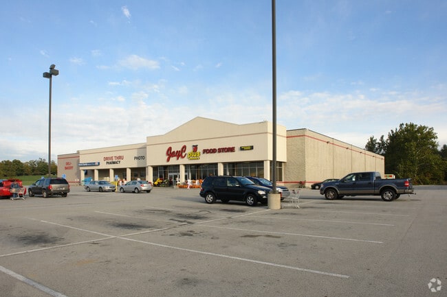
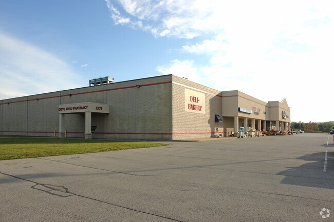
Supermarket
FLOYD
B and X Area of moderate flood hazard, usually the area between the limits of the 100-year and 500-year floods.
Indiana
2024
1 AC
2025
Outlying Floyd County
071003
Louisville
43,060 SF
Louisville/Jefferson County, KY-IN
NEARBY LISTINGS FOR SALE OR LEASE
DEMOGRAPHICS near Schreiber Rd
1 mile
3 mile
5 mile
2025 Total Population
1,570
14,132
50,489
2030 Population
1,617
14,407
51,553
Pop Growth 2025-2030
+ 2.99%
+ 1.95%
+ 2.11%
Average Age
42
42
41
2025 Total Households
562
5,339
20,094
HH Growth 2025-2030
+ 2.85%
+ 1.87%
+ 2.13%
Median Household Inc
$128,125
$111,487
$76,633
Avg Household Size
2.80
2.60
2.40
2025 Avg HH Vehicles
3.00
2.00
2.00
Median Home Value
$360,975
$321,535
$261,062
Median Year Built
1991
1987
1975
Nearby Places
Map Layers
Map Styles
 Street
 Aerial
Transit
 Traffic
 Biking
Places
Listings with unknown addresses are not visible on the map
- Restaurants
- Banks
- Shops
- Fitness
- Groceries
PUBLIC TRANSPORTATION
AIRPORT
Louisville Muhammad Ali International
Drive
Walk
Distance
Louisville Muhammad Ali International
31 min
18.7 mi
Nearby Properties
Address
Land Use
TOTAL SIZE
Lot Size
Zoning
Address
Land Use
TOTAL SIZE
Lot Size
Zoning
39,851 SF
19.68 AC
Address
Land Use
TOTAL SIZE
Lot Size
Zoning
34,308 SF
4.59 AC
Address
Land Use
TOTAL SIZE
Lot Size
Zoning
56,547 SF
5.65 AC
Address
Land Use
TOTAL SIZE
Lot Size
Zoning
26,864 SF
10.49 AC
Address
Land Use
TOTAL SIZE
Lot Size
Zoning
21,780 SF
11.44 AC
Address
Land Use
TOTAL SIZE
Lot Size
Zoning
3,600 SF
7.90 AC
Address
Land Use
TOTAL SIZE
Lot Size
Zoning
13,858 SF
11.28 AC
Address
Land Use
TOTAL SIZE
Lot Size
Zoning
12,329 SF
7.60 AC
Address
Land Use
TOTAL SIZE
Lot Size
Zoning
15,000 SF
1.69 AC
Address
Land Use
TOTAL SIZE
Lot Size
Zoning
25,660 SF
2.20 AC
Address
Land Use
TOTAL SIZE
Lot Size
Zoning
16,128 SF
3.86 AC
Address
Land Use
TOTAL SIZE
Lot Size
Zoning
16,920 SF
1.38 AC
Address
Land Use
TOTAL SIZE
Lot Size
Zoning
26,320 SF
10.49 AC
Address
Land Use
TOTAL SIZE
Lot Size
Zoning
17,050 SF
5.46 AC
Address
Land Use
TOTAL SIZE
Lot Size
Zoning
39.70 AC
Address
Land Use
TOTAL SIZE
Lot Size
Zoning
8,640 SF
1.31 AC
Address
Land Use
TOTAL SIZE
Lot Size
Zoning
14,742 SF
1.30 AC
Address
Land Use
TOTAL SIZE
Lot Size
Zoning
20,250 SF
2.04 AC
Address
Land Use
TOTAL SIZE
Lot Size
Zoning
7,832 SF
4.76 AC
Address
Land Use
TOTAL SIZE
Lot Size
Zoning
Address
Land Use
TOTAL SIZE
Lot Size
Zoning
13,726 SF
3.32 AC
Address
Land Use
TOTAL SIZE
Lot Size
Zoning
16,960 SF
1.32 AC
Address
Land Use
TOTAL SIZE
Lot Size
Zoning
840 SF
11.22 AC
Address
Land Use
TOTAL SIZE
Lot Size
Zoning
26,100 SF
7.37 AC
Address
Land Use
TOTAL SIZE
Lot Size
Zoning
10,582 SF
0.68 AC
Address
Land Use
TOTAL SIZE
Lot Size
Zoning
23,372 SF
1.82 AC
Address
Land Use
TOTAL SIZE
Lot Size
Zoning
8,048 SF
0.83 AC
Address
Land Use
TOTAL SIZE
Lot Size
Zoning
10,126 SF
5 AC
Address
Land Use
TOTAL SIZE
Lot Size
Zoning
12,200 SF
1.18 AC
The World's #1 Commercial Real Estate Marketplace
Connect with us
© 2026 CoStar Group
The information above has been obtained from sources believed reliable. While we do not doubt its accuracy we have not verified it and make no guarantee, warranty or representation about it. It is your responsibility to independently confirm its accuracy and completeness. Any projections, opinions, assumptions, or estimates used are for example only and do not represent the current or future performance of the property. The value of this transaction to you depends on tax and other factors which should be evaluated by your tax, financial, and legal advisors. You and your advisors should conduct a careful, independent investigation of the property to determine to your satisfaction the suitability of the property for your needs.