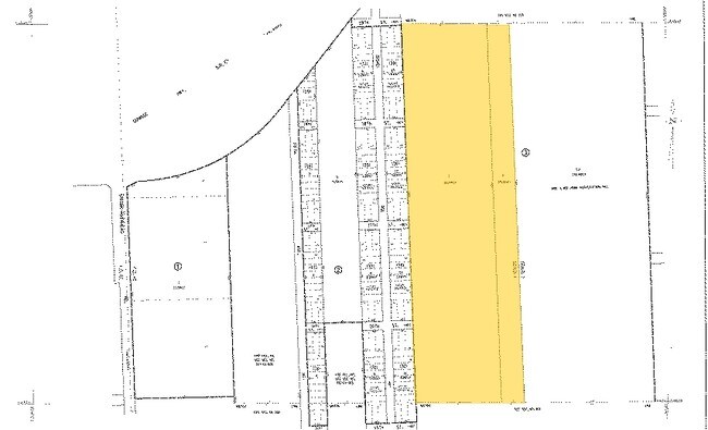
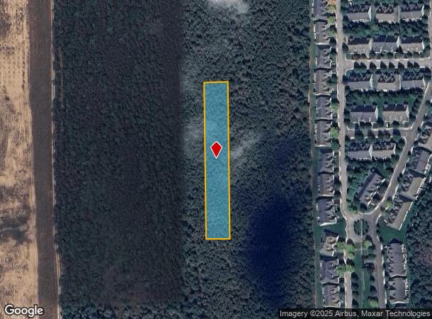
Property Record
Scrub Property, Lake Grove, NY 11755
NEARBY LISTINGS FOR SALE OR LEASE
Property Detail
Scrub Property
Nassau County-Suffolk County, NY
Hampton Terrace
0900-329-00-01-00-001-000
BLK 71 LOT 1-26
Vacantlandnec
Suffolk
X
New York
36103C0758H
1
0
1.49 AC
2024
Eastern Suffolk
158505
Long Island (New York)
DEMOGRAPHICS near Scrub Property
1 Mile
3 Mile
5 Mile
2024 Total Population
1,327
13,414
30,613
2029 Population
1,353
13,746
31,303
Pop Growth 2024-2029
+ 1.96%
+ 2.48%
+ 2.25%
Average Age
44
45
44
2024 Total Households
429
5,065
11,135
HH Growth 2024-2029
+ 2.10%
+ 2.47%
+ 2.42%
Median Household Inc
$86,607
$122,284
$120,775
Avg Household Size
2.70
2.50
2.70
2024 Avg HH Vehicles
2.00
2.00
2.00
Median Home Value
$718,894
$801,861
$755,511
Median Year Built
1996
1980
1982
Nearby Places
- Restaurants
- Banks
- Shops
- Fitness
- Groceries
PUBLIC TRANSPORTATION
COMMUTER RAIL
Speonk Station (Montauk Branch - Long Island Rail Road)
DRIVE
WALK
Distance
Speonk Station (Montauk Branch - Long Island Rail Road)
5 min
2.1 mi
Westhampton Station (Montauk Branch - Long Island Rail Road)
DRIVE
WALK
Distance
Westhampton Station (Montauk Branch - Long Island Rail Road)
8 min
3.6 mi
AIRPORT
Long Island MacArthur
DRIVE
WALK
Distance
Long Island MacArthur
40 min
24.8 mi
Freight Ports
Port of New Haven
DRIVE
WALK
Distance
Port of New Haven
156 min
65.3 mi
Nearby Properties
Address
Land Use
TOTAL SIZE
Lot Size
Zoning
Address
Land Use
TOTAL SIZE
Lot Size
Zoning
1,229.10 AC
LI200
Address
Land Use
TOTAL SIZE
Lot Size
Zoning
53,067 SF
6.20 AC
R2
Address
Land Use
TOTAL SIZE
Lot Size
Zoning
12,319 SF
192.30 AC
U25
Address
Land Use
TOTAL SIZE
Lot Size
Zoning
55,202 SF
18.50 AC
R2
Address
Land Use
TOTAL SIZE
Lot Size
Zoning
200 SF
67.80 AC
CR200
Address
Land Use
TOTAL SIZE
Lot Size
Zoning
68,676 SF
9.70 AC
CR200
Address
Land Use
TOTAL SIZE
Lot Size
Zoning
11.41 AC
LI200
Address
Land Use
TOTAL SIZE
Lot Size
Zoning
18.28 AC
CR200
Address
Land Use
TOTAL SIZE
Lot Size
Zoning
8.26 AC
LI200
Address
Land Use
TOTAL SIZE
Lot Size
Zoning
15,084 SF
10.25 AC
R40
Address
Land Use
TOTAL SIZE
Lot Size
Zoning
26,824 SF
146.40 AC
CR200
Address
Land Use
TOTAL SIZE
Lot Size
Zoning
87,569 SF
19 AC
R120
Address
Land Use
TOTAL SIZE
Lot Size
Zoning
28,458 SF
9.60 AC
LI40
Address
Land Use
TOTAL SIZE
Lot Size
Zoning
28.62 AC
R40
Address
Land Use
TOTAL SIZE
Lot Size
Zoning
20,697 SF
1.91 AC
B1
Address
Land Use
TOTAL SIZE
Lot Size
Zoning
36,918 SF
6.27 AC
R40
Address
Land Use
TOTAL SIZE
Lot Size
Zoning
7,270 SF
4.20 AC
R2
Address
Land Use
TOTAL SIZE
Lot Size
Zoning
30,512 SF
4.28 AC
VB
Address
Land Use
TOTAL SIZE
Lot Size
Zoning
16,854 SF
11.95 AC
OD
Address
Land Use
TOTAL SIZE
Lot Size
Zoning
92.10 AC
CR200
Address
Land Use
TOTAL SIZE
Lot Size
Zoning
20,822 SF
2.60 AC
B1
Address
Land Use
TOTAL SIZE
Lot Size
Zoning
6.42 AC
LI200
Address
Land Use
TOTAL SIZE
Lot Size
Zoning
8,636 SF
1.55 AC
R40
Address
Land Use
TOTAL SIZE
Lot Size
Zoning
9,069 SF
4.19 AC
R60
Address
Land Use
TOTAL SIZE
Lot Size
Zoning
7,032 SF
1.96 AC
R1
Address
Land Use
TOTAL SIZE
Lot Size
Zoning
1,500 SF
14.01 AC
CR200
Address
Land Use
TOTAL SIZE
Lot Size
Zoning
10,770 SF
1.50 AC
B1
Address
Land Use
TOTAL SIZE
Lot Size
Zoning
7.40 AC
R40
Address
Land Use
TOTAL SIZE
Lot Size
Zoning
90.50 AC
CR200
Address
Land Use
TOTAL SIZE
Lot Size
Zoning
3.66 AC
B3
The World's #1 Commercial Real Estate Marketplace
Connect with us
© 2025 CoStar Group
The information above has been obtained from sources believed reliable. While we do not doubt its accuracy we have not verified it and make no guarantee, warranty or representation about it. It is your responsibility to independently confirm its accuracy and completeness. Any projections, opinions, assumptions, or estimates used are for example only and do not represent the current or future performance of the property. The value of this transaction to you depends on tax and other factors which should be evaluated by your tax, financial, and legal advisors. You and your advisors should conduct a careful, independent investigation of the property to determine to your satisfaction the suitability of the property for your needs.