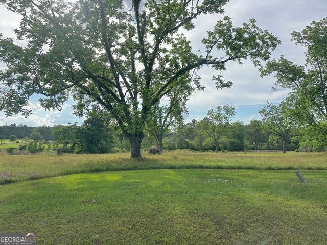
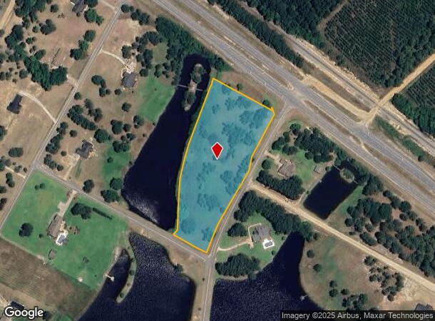
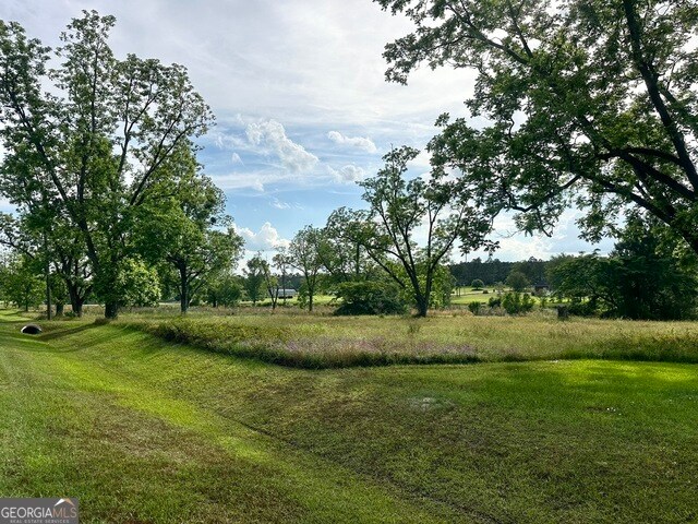
Property Record
Scuppernong Dr, Mc Rae Helena, GA 31037
NEARBY LISTINGS FOR SALE OR LEASE
-
-
View all Mc Rae Helena listings for sale on LoopNet.com
Property Detail
Scuppernong Dr
Other Market Areas
Whatley Vineyards
012A00-003-02
V/L 15H 584-85 LOTS 101-104
Residentialacreage
Telfair
A
Georgia
13271C0075C
101-104
2024
4 AC
2024
Georgia South Area
950102
DEMOGRAPHICS near Scuppernong Dr
1 Mile
3 Mile
5 Mile
2024 Total Population
222
2,880
7,047
2029 Population
222
2,870
7,082
Pop Growth 2024-2029
0.00%
(0.35%)
+ 0.50%
Average Age
40
41
41
2024 Total Households
63
911
2,327
HH Growth 2024-2029
(1.59%)
(1.32%)
(0.26%)
Median Household Inc
$40,500
$63,608
$46,462
Avg Household Size
2.50
2.40
2.40
2024 Avg HH Vehicles
2.00
2.00
2.00
Median Home Value
$89,999
$96,329
$86,620
Median Year Built
1991
1976
1975
Nearby Places
Map Layers
Map Styles
 Street
 Aerial
- Restaurants
- Banks
- Shops
- Fitness
- Groceries
SALE & LEASE HISTORY
LISTING DATE
SALE/LEASE

May 13, 2025
For Sale
Nearby Properties
Address
Land Use
TOTAL SIZE
Lot Size
Zoning
Address
Land Use
TOTAL SIZE
Lot Size
Zoning
3,633 SF
8.31 AC
RESIDENTIA
Address
Land Use
TOTAL SIZE
Lot Size
Zoning
17,572 SF
2.73 AC
RESIDENTIA
Address
Land Use
TOTAL SIZE
Lot Size
Zoning
1,584 SF
106.14 AC
001
Address
Land Use
TOTAL SIZE
Lot Size
Zoning
42,706 SF
4.42 AC
RESIDENTIA
Address
Land Use
TOTAL SIZE
Lot Size
Zoning
1,764 SF
0.30 AC
001
Address
Land Use
TOTAL SIZE
Lot Size
Zoning
1,152 SF
992.32 AC
RESIDENTIA
Address
Land Use
TOTAL SIZE
Lot Size
Zoning
29,250 SF
7.05 AC
RESIDENTIA
Address
Land Use
TOTAL SIZE
Lot Size
Zoning
15,775 SF
0.73 AC
RESIDENTIA
Address
Land Use
TOTAL SIZE
Lot Size
Zoning
4,627 SF
0.28 AC
RESIDENTIA
Address
Land Use
TOTAL SIZE
Lot Size
Zoning
1,045.65 AC
RESIDENTIA
Address
Land Use
TOTAL SIZE
Lot Size
Zoning
4,400 SF
0.69 AC
RESIDENTIA
Address
Land Use
TOTAL SIZE
Lot Size
Zoning
527.21 AC
001
Address
Land Use
TOTAL SIZE
Lot Size
Zoning
30,247 SF
2.11 AC
RESIDENTIA
Address
Land Use
TOTAL SIZE
Lot Size
Zoning
10,696 SF
2.44 AC
RESIDENTIA
Address
Land Use
TOTAL SIZE
Lot Size
Zoning
8,576 SF
1.22 AC
RESIDENTIA
Address
Land Use
TOTAL SIZE
Lot Size
Zoning
13,250 SF
11.98 AC
RESIDENTIA
Address
Land Use
TOTAL SIZE
Lot Size
Zoning
320.01 AC
RESIDENTIA
Address
Land Use
TOTAL SIZE
Lot Size
Zoning
268.04 AC
RESIDENTIA
Address
Land Use
TOTAL SIZE
Lot Size
Zoning
3,335 SF
1.05 AC
RESIDENTIA
Address
Land Use
TOTAL SIZE
Lot Size
Zoning
528 SF
1.31 AC
RESIDENTIA
Address
Land Use
TOTAL SIZE
Lot Size
Zoning
10,609 SF
0.83 AC
RESIDENTIA
Address
Land Use
TOTAL SIZE
Lot Size
Zoning
2,562 SF
0.93 AC
RESIDENTIA
Address
Land Use
TOTAL SIZE
Lot Size
Zoning
1,972 SF
5 AC
001
Address
Land Use
TOTAL SIZE
Lot Size
Zoning
6,456 SF
0.78 AC
RESIDENTIA
Address
Land Use
TOTAL SIZE
Lot Size
Zoning
1,902 SF
0.67 AC
RESIDENTIA
Address
Land Use
TOTAL SIZE
Lot Size
Zoning
4,334 SF
0.17 AC
RESIDENTIA
Address
Land Use
TOTAL SIZE
Lot Size
Zoning
804 SF
261.52 AC
RESIDENTIA
The World's #1 Commercial Real Estate Marketplace
Connect with us
© 2025 CoStar Group
The information above has been obtained from sources believed reliable. While we do not doubt its accuracy we have not verified it and make no guarantee, warranty or representation about it. It is your responsibility to independently confirm its accuracy and completeness. Any projections, opinions, assumptions, or estimates used are for example only and do not represent the current or future performance of the property. The value of this transaction to you depends on tax and other factors which should be evaluated by your tax, financial, and legal advisors. You and your advisors should conduct a careful, independent investigation of the property to determine to your satisfaction the suitability of the property for your needs.