Property Record
7192 Se 9Th Ave, Starke, FL 32091

Property Detail
7192 Se 9Th Ave
05220-0-00100
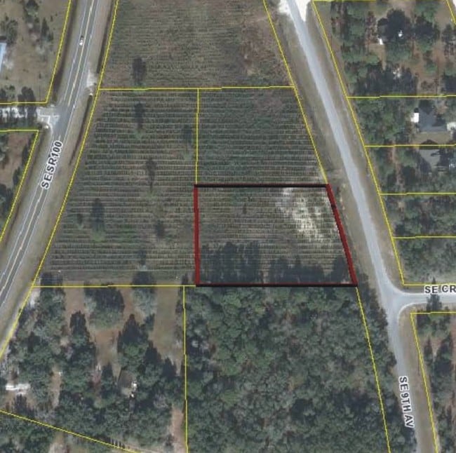
1 8S 22 A PORT OF TRACT B ON CRYSTAL LAKE HOMESITES. COM SW COR OF TRACT B, THENCE NELY ALONG W LINE OF TRACT B N21*5813E 227.57, THENCE S89*1149E 271.04 TO POB. S89*1149E 285.16 TO WLY R/W SE 9TH AVE, S14*4501E 220.30 TO SE COR OF TRACT B, THENCE N8
Commercialacreage
BRADFORD
B and X Area of moderate flood hazard, usually the area between the limits of the 100-year and 500-year floods.
Florida
2025
2.74 AC
2025
Florida Central North Area
000202
Other Market Areas
22,550 SF
NEARBY LISTINGS FOR SALE OR LEASE
DEMOGRAPHICS near 7192 Se 9Th Ave
1 mile
3 mile
5 mile
2025 Total Population
574
5,338
13,365
2030 Population
621
5,807
14,576
Pop Growth 2025-2030
+ 8.19%
+ 8.79%
+ 9.06%
Average Age
44
45
44
2025 Total Households
229
2,177
5,366
HH Growth 2025-2030
+ 7.42%
+ 8.68%
+ 9.00%
Median Household Inc
$77,917
$67,833
$68,173
Avg Household Size
2.50
2.40
2.50
2025 Avg HH Vehicles
2.00
2.00
2.00
Median Home Value
$170,930
$279,691
$275,494
Median Year Built
1975
1981
1984
Nearby Places
Map Layers
Map Styles
 Street
 Aerial
Transit
 Traffic
 Biking
Places
Listings with unknown addresses are not visible on the map
- Restaurants
- Banks
- Shops
- Fitness
- Groceries
PUBLIC TRANSPORTATION
AIRPORT
Gainesville Regional
Drive
Walk
Distance
Gainesville Regional
39 min
24.4 mi
Freight Ports
Jacksonville Port
Drive
Walk
Distance
Jacksonville Port
78 min
58.1 mi
SALE & LEASE HISTORY
LISTING DATE
SALE/LEASE

Sep 24, 2016
For Sale
Nearby Properties
Address
Land Use
TOTAL SIZE
Lot Size
Zoning
Address
Land Use
TOTAL SIZE
Lot Size
Zoning
23,953 SF
228.32 AC
Address
Land Use
TOTAL SIZE
Lot Size
Zoning
68,670 SF
10 AC
Address
Land Use
TOTAL SIZE
Lot Size
Zoning
116,370 SF
23.88 AC
PS-5
Address
Land Use
TOTAL SIZE
Lot Size
Zoning
52,626 SF
28.21 AC
Address
Land Use
TOTAL SIZE
Lot Size
Zoning
61,803 SF
18.29 AC
Address
Land Use
TOTAL SIZE
Lot Size
Zoning
123,219 SF
121 AC
Address
Land Use
TOTAL SIZE
Lot Size
Zoning
13,346 SF
622.95 AC
Address
Land Use
TOTAL SIZE
Lot Size
Zoning
22,485 SF
110 AC
Address
Land Use
TOTAL SIZE
Lot Size
Zoning
36,867 SF
127 AC
Address
Land Use
TOTAL SIZE
Lot Size
Zoning
63,693 SF
9.65 AC
Address
Land Use
TOTAL SIZE
Lot Size
Zoning
30,198 SF
140 AC
Address
Land Use
TOTAL SIZE
Lot Size
Zoning
21,704 SF
8.45 AC
Address
Land Use
TOTAL SIZE
Lot Size
Zoning
14,736 SF
2.13 AC
Address
Land Use
TOTAL SIZE
Lot Size
Zoning
8,266 SF
1.20 AC
Address
Land Use
TOTAL SIZE
Lot Size
Zoning
13,000 SF
2.24 AC
RB
Address
Land Use
TOTAL SIZE
Lot Size
Zoning
10,115 SF
0.92 AC
PO-1
Address
Land Use
TOTAL SIZE
Lot Size
Zoning
28,506 SF
1 AC
Address
Land Use
TOTAL SIZE
Lot Size
Zoning
589.03 AC
Address
Land Use
TOTAL SIZE
Lot Size
Zoning
492.81 AC
Address
Land Use
TOTAL SIZE
Lot Size
Zoning
3,133 SF
1.65 AC
Address
Land Use
TOTAL SIZE
Lot Size
Zoning
1,782 SF
1.09 AC
Address
Land Use
TOTAL SIZE
Lot Size
Zoning
9,146 SF
1.52 AC
Address
Land Use
TOTAL SIZE
Lot Size
Zoning
7,360 SF
0.84 AC
Address
Land Use
TOTAL SIZE
Lot Size
Zoning
36,286 SF
13.98 AC
Address
Land Use
TOTAL SIZE
Lot Size
Zoning
12,865 SF
18.18 AC
Address
Land Use
TOTAL SIZE
Lot Size
Zoning
320 AC
Address
Land Use
TOTAL SIZE
Lot Size
Zoning
Address
Land Use
TOTAL SIZE
Lot Size
Zoning
6,500 SF
437.49 AC
Address
Land Use
TOTAL SIZE
Lot Size
Zoning
8,320 SF
1.01 AC
CG
The World's #1 Commercial Real Estate Marketplace
Connect with us
© 2026 CoStar Group
The information above has been obtained from sources believed reliable. While we do not doubt its accuracy we have not verified it and make no guarantee, warranty or representation about it. It is your responsibility to independently confirm its accuracy and completeness. Any projections, opinions, assumptions, or estimates used are for example only and do not represent the current or future performance of the property. The value of this transaction to you depends on tax and other factors which should be evaluated by your tax, financial, and legal advisors. You and your advisors should conduct a careful, independent investigation of the property to determine to your satisfaction the suitability of the property for your needs.