Property Record
Se Hunter & 8Th Sts, Camden, NJ 08104
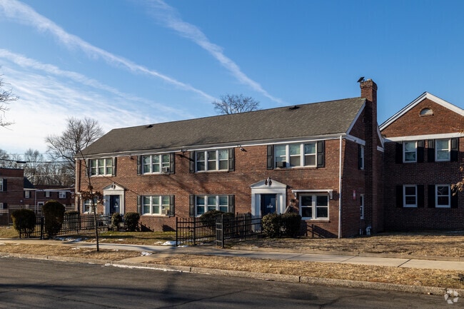
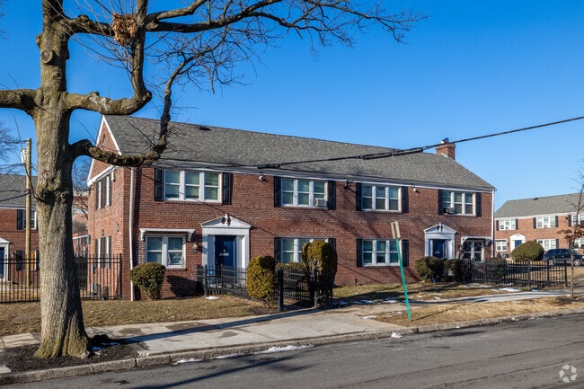
Property Detail
Se Hunter & 8Th Sts
Philadelphia-Camden-Wilmington, PA-NJ-DE-MD
FACILITY NAME: IN-LIEU TAX PAYMENT
08-00644-0000-00046
CAMDEN
Taxexempt
New Jersey
B and X Area of moderate flood hazard, usually the area between the limits of the 100-year and 500-year floods.
45
0
1.81 AC
2026
Morgan Village
601700
Philadelphia
NEARBY LISTINGS FOR SALE OR LEASE
-
-
-
-
-
No Photo
-
-
-
View all Camden listings for sale on LoopNet.com
DEMOGRAPHICS near Se Hunter & 8Th Sts
1 mile
3 mile
5 mile
2025 Total Population
20,125
199,576
587,128
2030 Population
20,975
202,153
592,922
Pop Growth 2025-2030
+ 4.22%
+ 1.29%
+ 0.99%
Average Age
35
38
39
2025 Total Households
7,327
78,623
256,589
HH Growth 2025-2030
+ 4.34%
+ 1.06%
+ 0.74%
Median Household Inc
$43,832
$70,080
$83,799
Avg Household Size
2.70
2.40
2.20
2025 Avg HH Vehicles
1.00
1.00
1.00
Median Home Value
$92,972
$286,966
$342,509
Median Year Built
1949
1948
1951
Nearby Places
Map Layers
Map Styles
 Street
 Aerial
Layers
 Traffic
 Biking
Places
Listings with unknown addresses are not visible on the map
- Restaurants
- Banks
- Shops
- Fitness
- Groceries
PUBLIC TRANSPORTATION
COMMUTER RAIL
Market East (R1 - Southeastern Pennsylvania Transportation Authority Regional Rail (SEPTA Regional Rail), R2 - Southeastern Pennsylvania Transportation Authority Regional Rail (SEPTA Regional Rail), R3 - Southeastern Pennsylvania Transportation Authority Regional Rail (SEPTA Regional Rail), R5 - Southeastern Pennsylvania Transportation Authority Regional Rail (SEPTA Regional Rail), R6 - Southeastern Pennsylvania Transportation Authority Regional Rail (SEPTA Regional Rail), R7 - Southeastern Pennsylvania Transportation Authority Regional Rail (SEPTA Regional Rail), R8 - Southeastern Pennsylvania Transportation Authority Regional Rail (SEPTA Regional Rail))
Drive
Walk
Distance
Market East (R1 - Southeastern Pennsylvania Transportation Authority Regional Rail (SEPTA Regional Rail), R2 - Southeastern Pennsylvania Transportation Authority Regional Rail (SEPTA Regional Rail), R3 - Southeastern Pennsylvania Transportation Authority Regional Rail (SEPTA Regional Rail), R5 - Southeastern Pennsylvania Transportation Authority Regional Rail (SEPTA Regional Rail), R6 - Southeastern Pennsylvania Transportation Authority Regional Rail (SEPTA Regional Rail), R7 - Southeastern Pennsylvania Transportation Authority Regional Rail (SEPTA Regional Rail), R8 - Southeastern Pennsylvania Transportation Authority Regional Rail (SEPTA Regional Rail))
10 min
5.4 mi
Cherry Hill (Atlantic City Line - NJ Transit Commuter Rail (NJ Transit))
Drive
Walk
Distance
Cherry Hill (Atlantic City Line - NJ Transit Commuter Rail (NJ Transit))
10 min
5.5 mi
AIRPORT
Philadelphia International
Drive
Walk
Distance
Philadelphia International
21 min
11.1 mi
Trenton Mercer
Drive
Walk
Distance
Trenton Mercer
54 min
37.3 mi
Freight Ports
Broadway Terminal - Pier 5
Drive
Walk
Distance
Broadway Terminal - Pier 5
2 min
0.8 mi
Nearby Properties
Address
Land Use
TOTAL SIZE
Lot Size
Zoning
Address
Land Use
TOTAL SIZE
Lot Size
Zoning
608,400 SF
43.23 AC
SPSTA
Address
Land Use
TOTAL SIZE
Lot Size
Zoning
11,513 SF
19.92 AC
SPSTA
Address
Land Use
TOTAL SIZE
Lot Size
Zoning
159,630 SF
9.15 AC
SPENT
Address
Land Use
TOTAL SIZE
Lot Size
Zoning
1.17 AC
Address
Land Use
TOTAL SIZE
Lot Size
Zoning
7.17 AC
Address
Land Use
TOTAL SIZE
Lot Size
Zoning
124.13 AC
Address
Land Use
TOTAL SIZE
Lot Size
Zoning
Address
Land Use
TOTAL SIZE
Lot Size
Zoning
80,064 SF
51.52 AC
I3
Address
Land Use
TOTAL SIZE
Lot Size
Zoning
12.53 AC
Address
Land Use
TOTAL SIZE
Lot Size
Zoning
1.62 AC
Address
Land Use
TOTAL SIZE
Lot Size
Zoning
Address
Land Use
TOTAL SIZE
Lot Size
Zoning
11.06 AC
CMX3
Address
Land Use
TOTAL SIZE
Lot Size
Zoning
289,664 SF
0.22 AC
CMX3
Address
Land Use
TOTAL SIZE
Lot Size
Zoning
2.32 AC
Address
Land Use
TOTAL SIZE
Lot Size
Zoning
7.11 AC
Address
Land Use
TOTAL SIZE
Lot Size
Zoning
441,600 SF
1.68 AC
CMX4
Address
Land Use
TOTAL SIZE
Lot Size
Zoning
256,280 SF
2.54 AC
CMX3
Address
Land Use
TOTAL SIZE
Lot Size
Zoning
1.88 AC
Address
Land Use
TOTAL SIZE
Lot Size
Zoning
1.68 AC
Address
Land Use
TOTAL SIZE
Lot Size
Zoning
6.43 AC
Address
Land Use
TOTAL SIZE
Lot Size
Zoning
Address
Land Use
TOTAL SIZE
Lot Size
Zoning
189,272 SF
1.32 AC
CMX3
Address
Land Use
TOTAL SIZE
Lot Size
Zoning
31.99 AC
Address
Land Use
TOTAL SIZE
Lot Size
Zoning
47.20 AC
I3
Address
Land Use
TOTAL SIZE
Lot Size
Zoning
272,918 SF
23.03 AC
CA2
Address
Land Use
TOTAL SIZE
Lot Size
Zoning
16,872 SF
RH
Address
Land Use
TOTAL SIZE
Lot Size
Zoning
1,504 SF
61.44 AC
Address
Land Use
TOTAL SIZE
Lot Size
Zoning
39,080 SF
18.60 AC
C2
Address
Land Use
TOTAL SIZE
Lot Size
Zoning
1.48 AC
PCR
Address
Land Use
TOTAL SIZE
Lot Size
Zoning
35 AC
R1
The World's #1 Commercial Real Estate Marketplace
Connect with us
© 2026 CoStar Group
The information above has been obtained from sources believed reliable. While we do not doubt its accuracy we have not verified it and make no guarantee, warranty or representation about it. It is your responsibility to independently confirm its accuracy and completeness. Any projections, opinions, assumptions, or estimates used are for example only and do not represent the current or future performance of the property. The value of this transaction to you depends on tax and other factors which should be evaluated by your tax, financial, and legal advisors. You and your advisors should conduct a careful, independent investigation of the property to determine to your satisfaction the suitability of the property for your needs.