Property Record
6935 N Apache Rd, Buckeye, AZ 85326
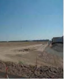
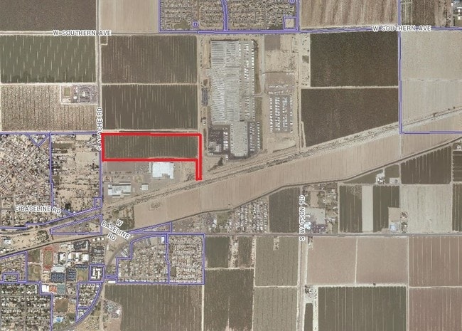

Property Detail
6935 N Apache Rd
504-46-024F
BEG W4 COR SEC 33 TH S 374.76F TPOB TH E 1320.49F TO E LN NW4 SW4 TH N 327.55F TO S LN N 40F TH W 1320.38F TO W LN TH S 334.76F TO POB EX W 65F & E X N 40F
Farms
MARICOPA
I-1
Arizona
C and X Area of minimal flood hazard, usually depicted on FIRMs as above the 500-year flood level.
9.54 AC
2025
West I-10
2025
Phoenix
050611
Phoenix-Mesa-Chandler, AZ
NEARBY LISTINGS FOR SALE OR LEASE
-
-
-
-
No Photo
-
-
-
-
View all Buckeye listings for sale on LoopNet.com
DEMOGRAPHICS near 6935 N Apache Rd
1 mile
3 mile
5 mile
2025 Total Population
6,002
34,152
62,911
2030 Population
6,327
36,463
66,562
Pop Growth 2025-2030
+ 5.41%
+ 6.77%
+ 5.80%
Average Age
34
34
35
2025 Total Households
1,789
10,165
18,823
HH Growth 2025-2030
+ 5.42%
+ 6.83%
+ 5.88%
Median Household Inc
$85,467
$86,823
$91,554
Avg Household Size
3.30
3.30
3.30
2025 Avg HH Vehicles
2.00
2.00
2.00
Median Home Value
$327,544
$361,675
$375,691
Median Year Built
2002
2008
2007
Nearby Places
Map Layers
Map Styles
 Street
 Aerial
Transit
 Traffic
 Biking
Places
Listings with unknown addresses are not visible on the map
- Restaurants
- Banks
- Shops
- Fitness
- Groceries
SALE & LEASE HISTORY
LISTING DATE
SALE/LEASE

Sep 24, 2016
For Sale
Oct 04, 2017
For Sale
Oct 02, 2017
For Sale
Nearby Properties
Address
Land Use
TOTAL SIZE
Lot Size
Zoning
Address
Land Use
TOTAL SIZE
Lot Size
Zoning
2,310,631 SF
215.58 AC
Address
Land Use
TOTAL SIZE
Lot Size
Zoning
1,207,360 SF
67.69 AC
Address
Land Use
TOTAL SIZE
Lot Size
Zoning
13.35 AC
Address
Land Use
TOTAL SIZE
Lot Size
Zoning
1,834,456 SF
142.44 AC
C-G
Address
Land Use
TOTAL SIZE
Lot Size
Zoning
11.14 AC
Address
Land Use
TOTAL SIZE
Lot Size
Zoning
3,494 SF
6.20 AC
GC
Address
Land Use
TOTAL SIZE
Lot Size
Zoning
510,427 SF
64.69 AC
GC
Address
Land Use
TOTAL SIZE
Lot Size
Zoning
290,752 SF
21.32 AC
SU
Address
Land Use
TOTAL SIZE
Lot Size
Zoning
269,665 SF
54.66 AC
PC
Address
Land Use
TOTAL SIZE
Lot Size
Zoning
174.17 AC
Address
Land Use
TOTAL SIZE
Lot Size
Zoning
93,337 SF
15.37 AC
PC
Address
Land Use
TOTAL SIZE
Lot Size
Zoning
78,774 SF
7.57 AC
PUD
Address
Land Use
TOTAL SIZE
Lot Size
Zoning
122,714 SF
12.27 AC
C-C
Address
Land Use
TOTAL SIZE
Lot Size
Zoning
68,255 SF
3.16 AC
PUD
Address
Land Use
TOTAL SIZE
Lot Size
Zoning
85,712 SF
15.18 AC
PR
Address
Land Use
TOTAL SIZE
Lot Size
Zoning
228,652 SF
136.91 AC
SU
Address
Land Use
TOTAL SIZE
Lot Size
Zoning
8,144 SF
39.69 AC
R-43
Address
Land Use
TOTAL SIZE
Lot Size
Zoning
60,201 SF
14.10 AC
PUD
Address
Land Use
TOTAL SIZE
Lot Size
Zoning
125,120 SF
8.49 AC
SU
Address
Land Use
TOTAL SIZE
Lot Size
Zoning
181,308 SF
20.19 AC
C-G
Address
Land Use
TOTAL SIZE
Lot Size
Zoning
20,248 SF
23.16 AC
SU
Address
Land Use
TOTAL SIZE
Lot Size
Zoning
3.10 AC
Address
Land Use
TOTAL SIZE
Lot Size
Zoning
178,939 SF
13.98 AC
CC
Address
Land Use
TOTAL SIZE
Lot Size
Zoning
150,139 SF
20.48 AC
C-G
Address
Land Use
TOTAL SIZE
Lot Size
Zoning
136,836 SF
8.85 AC
R-R
Address
Land Use
TOTAL SIZE
Lot Size
Zoning
26,239 SF
6.26 AC
RR
Address
Land Use
TOTAL SIZE
Lot Size
Zoning
30,320 SF
13.81 AC
PAD
Address
Land Use
TOTAL SIZE
Lot Size
Zoning
53.11 AC
C-G
Address
Land Use
TOTAL SIZE
Lot Size
Zoning
40,859 SF
6.92 AC
PUD
Address
Land Use
TOTAL SIZE
Lot Size
Zoning
The World's #1 Commercial Real Estate Marketplace
Connect with us
© 2026 CoStar Group
The information above has been obtained from sources believed reliable. While we do not doubt its accuracy we have not verified it and make no guarantee, warranty or representation about it. It is your responsibility to independently confirm its accuracy and completeness. Any projections, opinions, assumptions, or estimates used are for example only and do not represent the current or future performance of the property. The value of this transaction to you depends on tax and other factors which should be evaluated by your tax, financial, and legal advisors. You and your advisors should conduct a careful, independent investigation of the property to determine to your satisfaction the suitability of the property for your needs.