Property Record
17500 S Woodland Rd, Olathe, KS 66062
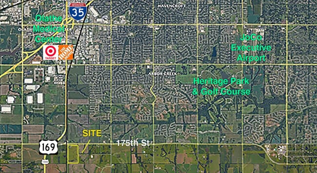
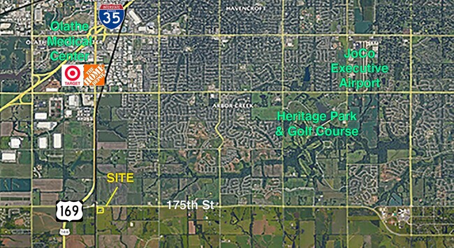
This Property Is For Sale
Property Detail
17500 S Woodland Rd
9F231425-1005
25-14-23 BEG 150 FT E NW COR NW1/4 S 255.35 FT X E 118.65 FT EX W 25 FT & N 25 FT FOR HWY .69 AC SP -0005A0002
Storebuilding
JOHNSON
PRB1
Kansas
B and X Area of moderate flood hazard, usually the area between the limits of the 100-year and 500-year floods.
0.50 AC
2024
South Johnson County
2025
Kansas City
053801
Kansas City, MO-KS
1,320 SF
NEARBY LISTINGS FOR SALE OR LEASE
DEMOGRAPHICS near 17500 S Woodland Rd
1 mile
3 mile
5 mile
2025 Total Population
215
21,019
78,059
2030 Population
227
22,046
80,846
Pop Growth 2025-2030
+ 5.58%
+ 4.89%
+ 3.57%
Average Age
38
38
38
2025 Total Households
74
7,032
26,519
HH Growth 2025-2030
+ 5.41%
+ 5.05%
+ 3.76%
Median Household Inc
$114,583
$126,286
$111,203
Avg Household Size
2.90
2.90
2.80
2025 Avg HH Vehicles
2.00
2.00
2.00
Median Home Value
$454,545
$405,429
$352,878
Median Year Built
2009
2004
1992
Nearby Places
Map Layers
Map Styles
 Street
 Aerial
Transit
 Traffic
 Biking
Places
Listings with unknown addresses are not visible on the map
- Restaurants
- Banks
- Shops
- Fitness
- Groceries
Nearby Properties
Address
Land Use
TOTAL SIZE
Lot Size
Zoning
Address
Land Use
TOTAL SIZE
Lot Size
Zoning
401,604 SF
28.35 AC
CP-O
Address
Land Use
TOTAL SIZE
Lot Size
Zoning
1,060,732 SF
57.62 AC
MP-2
Address
Land Use
TOTAL SIZE
Lot Size
Zoning
327,169 SF
141.81 AC
R-R
Address
Land Use
TOTAL SIZE
Lot Size
Zoning
720,320 SF
39.19 AC
MP-2
Address
Land Use
TOTAL SIZE
Lot Size
Zoning
130,576 SF
15.20 AC
RP-4
Address
Land Use
TOTAL SIZE
Lot Size
Zoning
508,664 SF
29.46 AC
MP-2
Address
Land Use
TOTAL SIZE
Lot Size
Zoning
320,835 SF
57.95 AC
M-2
Address
Land Use
TOTAL SIZE
Lot Size
Zoning
499,084 SF
28.99 AC
RUR
Address
Land Use
TOTAL SIZE
Lot Size
Zoning
103,102 SF
31.90 AC
R-1
Address
Land Use
TOTAL SIZE
Lot Size
Zoning
137,955 SF
23.80 AC
R-1
Address
Land Use
TOTAL SIZE
Lot Size
Zoning
236,108 SF
12.38 AC
R-1
Address
Land Use
TOTAL SIZE
Lot Size
Zoning
102,280 SF
30.53 AC
RP-4
Address
Land Use
TOTAL SIZE
Lot Size
Zoning
70,643 SF
18.45 AC
RP-1
Address
Land Use
TOTAL SIZE
Lot Size
Zoning
75,560 SF
32.62 AC
CTY RUR
Address
Land Use
TOTAL SIZE
Lot Size
Zoning
320,891 SF
39.07 AC
M-2
Address
Land Use
TOTAL SIZE
Lot Size
Zoning
71,221 SF
17.13 AC
R-1
Address
Land Use
TOTAL SIZE
Lot Size
Zoning
244,992 SF
15.75 AC
MP-2
Address
Land Use
TOTAL SIZE
Lot Size
Zoning
212,032 SF
9.53 AC
RUR
Address
Land Use
TOTAL SIZE
Lot Size
Zoning
71,221 SF
13.84 AC
R-1
Address
Land Use
TOTAL SIZE
Lot Size
Zoning
141,540 SF
9.23 AC
R-1
Address
Land Use
TOTAL SIZE
Lot Size
Zoning
71,221 SF
14.16 AC
Address
Land Use
TOTAL SIZE
Lot Size
Zoning
72,091 SF
11.33 AC
R-1
Address
Land Use
TOTAL SIZE
Lot Size
Zoning
69,723 SF
11.29 AC
R-1
Address
Land Use
TOTAL SIZE
Lot Size
Zoning
137,532 SF
12.02 AC
M-2
Address
Land Use
TOTAL SIZE
Lot Size
Zoning
65,691 SF
11.51 AC
RP-1
Address
Land Use
TOTAL SIZE
Lot Size
Zoning
127,880 SF
5.77 AC
M-2
Address
Land Use
TOTAL SIZE
Lot Size
Zoning
688,460 SF
116.12 AC
MP-2
Address
Land Use
TOTAL SIZE
Lot Size
Zoning
601,670 SF
37.16 AC
MP-2
Address
Land Use
TOTAL SIZE
Lot Size
Zoning
39,516 SF
6.69 AC
CP-1
Address
Land Use
TOTAL SIZE
Lot Size
Zoning
418,969 SF
48.14 AC
M-2
The World's #1 Commercial Real Estate Marketplace
Connect with us
© 2026 CoStar Group
The information above has been obtained from sources believed reliable. While we do not doubt its accuracy we have not verified it and make no guarantee, warranty or representation about it. It is your responsibility to independently confirm its accuracy and completeness. Any projections, opinions, assumptions, or estimates used are for example only and do not represent the current or future performance of the property. The value of this transaction to you depends on tax and other factors which should be evaluated by your tax, financial, and legal advisors. You and your advisors should conduct a careful, independent investigation of the property to determine to your satisfaction the suitability of the property for your needs.