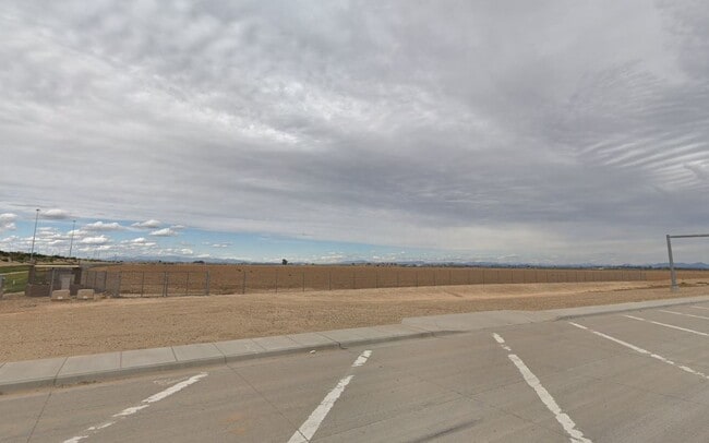
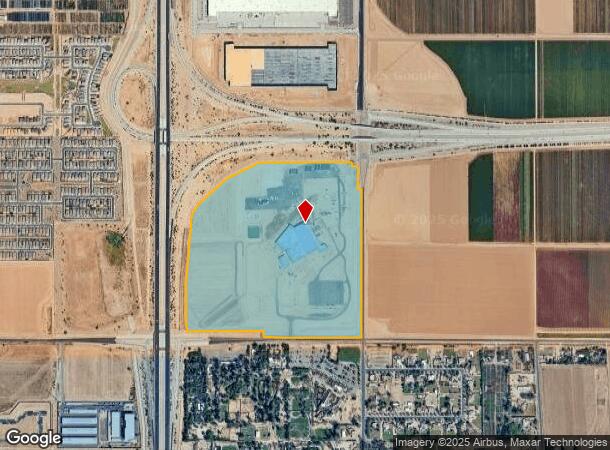
Property Record
8200 N Sarival Ave, Waddell, AZ 85355
NEARBY LISTINGS FOR SALE OR LEASE
Property Detail
8200 N Sarival Ave
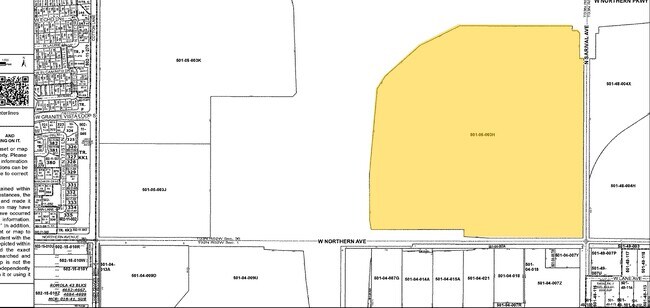
501-05-003H
SE4 OF SECTION 36 T3N R2W EX TH POR LY W/IN THE FOL DESC PROP BEG AT S4 COR SD SEC TH W ALG S LN SW4 SD SEC 300F TH N 400F TH N 06D 36M E 1358.50F TH N 1792.44FTH N 06D 04M W 1358.33F TH N 400F TO THE N LN NW4 SD SEC TH E ALG SD N LN 300F TO N4 COR S
Federalproperty
Maricopa
X
Arizona
04013C1670L
110.31 AC
0
Loop 303/Surprise
2025
Phoenix
061044
Phoenix-Mesa-Scottsdale, AZ
DEMOGRAPHICS near 8200 N Sarival Ave
1 Mile
3 Mile
5 Mile
2024 Total Population
2,347
28,061
119,317
2029 Population
2,707
31,047
131,578
Pop Growth 2024-2029
+ 15.34%
+ 10.64%
+ 10.28%
Average Age
38
36
37
2024 Total Households
733
8,411
37,766
HH Growth 2024-2029
+ 15.28%
+ 10.90%
+ 10.42%
Median Household Inc
$92,659
$99,811
$101,874
Avg Household Size
3.10
3.20
3.10
2024 Avg HH Vehicles
3.00
2.00
2.00
Median Home Value
$400,273
$401,229
$411,042
Median Year Built
2010
2008
2006
Nearby Places
Map Layers
Map Styles
 Street
 Aerial
- Restaurants
- Banks
- Shops
- Fitness
- Groceries
PUBLIC TRANSPORTATION
AIRPORT
Phoenix Sky Harbor International
DRIVE
WALK
Distance
Phoenix Sky Harbor International
44 min
33.7 mi
Freight Ports
Port of San Diego
DRIVE
WALK
Distance
Port of San Diego
379 min
341.0 mi
Nearby Properties
Address
Land Use
TOTAL SIZE
Lot Size
Zoning
Address
Land Use
TOTAL SIZE
Lot Size
Zoning
73.09 AC
Address
Land Use
TOTAL SIZE
Lot Size
Zoning
1,201,280 SF
74.43 AC
PAD
Address
Land Use
TOTAL SIZE
Lot Size
Zoning
1,758,410 SF
98.58 AC
PAD
Address
Land Use
TOTAL SIZE
Lot Size
Zoning
1,192,719 SF
70.75 AC
Address
Land Use
TOTAL SIZE
Lot Size
Zoning
915,160 SF
53.89 AC
Address
Land Use
TOTAL SIZE
Lot Size
Zoning
1,155,404 SF
75.47 AC
Address
Land Use
TOTAL SIZE
Lot Size
Zoning
1,259,666 SF
71.73 AC
R-43
Address
Land Use
TOTAL SIZE
Lot Size
Zoning
1,200,140 SF
76.91 AC
Address
Land Use
TOTAL SIZE
Lot Size
Zoning
1,109,869 SF
67.32 AC
R-43
Address
Land Use
TOTAL SIZE
Lot Size
Zoning
1,253,382 SF
74.13 AC
Address
Land Use
TOTAL SIZE
Lot Size
Zoning
25.69 AC
Address
Land Use
TOTAL SIZE
Lot Size
Zoning
570,080 SF
36.76 AC
Address
Land Use
TOTAL SIZE
Lot Size
Zoning
1,178,814 SF
64.63 AC
Address
Land Use
TOTAL SIZE
Lot Size
Zoning
634,560 SF
36.84 AC
PAD
Address
Land Use
TOTAL SIZE
Lot Size
Zoning
563,781 SF
34.84 AC
PAD
Address
Land Use
TOTAL SIZE
Lot Size
Zoning
522,480 SF
31.89 AC
Address
Land Use
TOTAL SIZE
Lot Size
Zoning
897,328 SF
53.70 AC
Address
Land Use
TOTAL SIZE
Lot Size
Zoning
216,334 SF
55.45 AC
R16
Address
Land Use
TOTAL SIZE
Lot Size
Zoning
278,670 SF
40.72 AC
Address
Land Use
TOTAL SIZE
Lot Size
Zoning
20.79 AC
Address
Land Use
TOTAL SIZE
Lot Size
Zoning
198,109 SF
79 AC
R-43
Address
Land Use
TOTAL SIZE
Lot Size
Zoning
455,936 SF
23.97 AC
Address
Land Use
TOTAL SIZE
Lot Size
Zoning
349,633 SF
23.03 AC
Address
Land Use
TOTAL SIZE
Lot Size
Zoning
6,208 SF
26.08 AC
Address
Land Use
TOTAL SIZE
Lot Size
Zoning
272,096 SF
22.82 AC
PAD
Address
Land Use
TOTAL SIZE
Lot Size
Zoning
364,700 SF
22.20 AC
Address
Land Use
TOTAL SIZE
Lot Size
Zoning
345,916 SF
30.97 AC
PAD
Address
Land Use
TOTAL SIZE
Lot Size
Zoning
90,387 SF
14.97 AC
PAD
Address
Land Use
TOTAL SIZE
Lot Size
Zoning
797,969 SF
66.20 AC
PAD
The World's #1 Commercial Real Estate Marketplace
Connect with us
© 2026 CoStar Group
The information above has been obtained from sources believed reliable. While we do not doubt its accuracy we have not verified it and make no guarantee, warranty or representation about it. It is your responsibility to independently confirm its accuracy and completeness. Any projections, opinions, assumptions, or estimates used are for example only and do not represent the current or future performance of the property. The value of this transaction to you depends on tax and other factors which should be evaluated by your tax, financial, and legal advisors. You and your advisors should conduct a careful, independent investigation of the property to determine to your satisfaction the suitability of the property for your needs.