Property Record
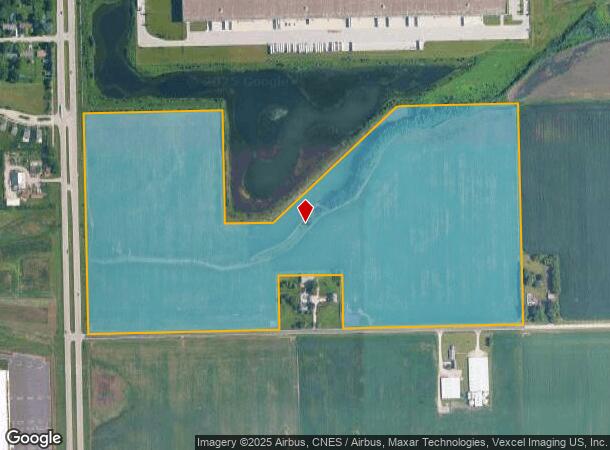
W Breen Rd, Elwood, IL 60421
Current Lease Availabilities
NEARBY LISTINGS FOR SALE OR LEASE
Property Detail
W Breen Rd
10-11-10-100-010
ASSESSMENT DESCRIPTION: THE S1/2 OF THE NW1/4 OF SEC 10, T34N R10E (EX THAT PRT DAF: THAT PRT OF THE S1/2 OF THE NW 1/4 OF SE
Agriculturalland
Will
A
Illinois
17197C0280G
67.02 AC
2024
Joliet Area
2024
Chicago
883307
Chicago-Naperville-Elgin, IL-IN-WI
DEMOGRAPHICS near W Breen Rd
1 Mile
3 Mile
5 Mile
2024 Total Population
555
3,469
29,700
2029 Population
568
3,532
29,901
Pop Growth 2024-2029
+ 2.34%
+ 1.82%
+ 0.68%
Average Age
46
43
39
2024 Total Households
220
1,354
10,414
HH Growth 2024-2029
+ 2.27%
+ 1.77%
+ 0.63%
Median Household Inc
$111,918
$91,756
$73,510
Avg Household Size
2.50
2.60
2.80
2024 Avg HH Vehicles
3.00
2.00
2.00
Median Home Value
$253,599
$231,569
$225,253
Median Year Built
1977
1977
1975
Nearby Places
- Restaurants
- Banks
- Shops
- Fitness
- Groceries
PUBLIC TRANSPORTATION
COMMUTER RAIL
Joliet Station (Heritage Corridor Line - Northeast Illinois Regional Commuter Railroad (Metra), Rock Island District Line - Northeast Illinois Regional Commuter Railroad (Metra))
DRIVE
WALK
Distance
Joliet Station (Heritage Corridor Line - Northeast Illinois Regional Commuter Railroad (Metra), Rock Island District Line - Northeast Illinois Regional Commuter Railroad (Metra))
11 min
5.9 mi
Manhattan Station (SouthWest Service - Northeast Illinois Regional Commuter Railroad (Metra))
DRIVE
WALK
Distance
Manhattan Station (SouthWest Service - Northeast Illinois Regional Commuter Railroad (Metra))
12 min
6.6 mi
AIRPORT
Chicago Midway International
DRIVE
WALK
Distance
Chicago Midway International
56 min
41.7 mi
Freight Ports
Port Milwaukee
DRIVE
WALK
Distance
Port Milwaukee
154 min
124.9 mi
Nearby Properties
Address
Land Use
TOTAL SIZE
Lot Size
Zoning
Address
Land Use
TOTAL SIZE
Lot Size
Zoning
88.74 AC
Address
Land Use
TOTAL SIZE
Lot Size
Zoning
67.82 AC
Address
Land Use
TOTAL SIZE
Lot Size
Zoning
81.93 AC
Address
Land Use
TOTAL SIZE
Lot Size
Zoning
59.92 AC
Address
Land Use
TOTAL SIZE
Lot Size
Zoning
40.74 AC
Address
Land Use
TOTAL SIZE
Lot Size
Zoning
64.27 AC
Address
Land Use
TOTAL SIZE
Lot Size
Zoning
61,681 SF
70.64 AC
Address
Land Use
TOTAL SIZE
Lot Size
Zoning
41.70 AC
Address
Land Use
TOTAL SIZE
Lot Size
Zoning
51.81 AC
Address
Land Use
TOTAL SIZE
Lot Size
Zoning
49.35 AC
Address
Land Use
TOTAL SIZE
Lot Size
Zoning
37.57 AC
Address
Land Use
TOTAL SIZE
Lot Size
Zoning
52.66 AC
Address
Land Use
TOTAL SIZE
Lot Size
Zoning
24.66 AC
Address
Land Use
TOTAL SIZE
Lot Size
Zoning
22.24 AC
Address
Land Use
TOTAL SIZE
Lot Size
Zoning
34.48 AC
Address
Land Use
TOTAL SIZE
Lot Size
Zoning
Address
Land Use
TOTAL SIZE
Lot Size
Zoning
36.54 AC
Address
Land Use
TOTAL SIZE
Lot Size
Zoning
16.02 AC
Address
Land Use
TOTAL SIZE
Lot Size
Zoning
18.88 AC
Address
Land Use
TOTAL SIZE
Lot Size
Zoning
21.47 AC
Address
Land Use
TOTAL SIZE
Lot Size
Zoning
5.12 AC
Address
Land Use
TOTAL SIZE
Lot Size
Zoning
26.83 AC
Address
Land Use
TOTAL SIZE
Lot Size
Zoning
10.73 AC
Address
Land Use
TOTAL SIZE
Lot Size
Zoning
20.74 AC
Address
Land Use
TOTAL SIZE
Lot Size
Zoning
47.34 AC
Address
Land Use
TOTAL SIZE
Lot Size
Zoning
11.04 AC
Address
Land Use
TOTAL SIZE
Lot Size
Zoning
12.08 AC
Address
Land Use
TOTAL SIZE
Lot Size
Zoning
16.43 AC
Address
Land Use
TOTAL SIZE
Lot Size
Zoning
46.83 AC
Address
Land Use
TOTAL SIZE
Lot Size
Zoning
186.23 AC
The World's #1 Commercial Real Estate Marketplace
Connect with us
© 2025 CoStar Group
The information above has been obtained from sources believed reliable. While we do not doubt its accuracy we have not verified it and make no guarantee, warranty or representation about it. It is your responsibility to independently confirm its accuracy and completeness. Any projections, opinions, assumptions, or estimates used are for example only and do not represent the current or future performance of the property. The value of this transaction to you depends on tax and other factors which should be evaluated by your tax, financial, and legal advisors. You and your advisors should conduct a careful, independent investigation of the property to determine to your satisfaction the suitability of the property for your needs.