Property Record
Sec Mimosa & Se Powell Valley Rd, Gresham, OR 97080
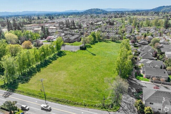

Property Detail
Sec Mimosa & Se Powell Valley Rd
R339848
SECTION 13 1S 3E, TL 4200 2.84 ACRES
Residentialacreage
MULTNOMAH
TR
Oregon
B and X Area of moderate flood hazard, usually the area between the limits of the 100-year and 500-year floods.
0.98 AC
0
Gresham
2025
Portland
009907
Portland-Vancouver-Hillsboro, OR-WA
NEARBY LISTINGS FOR SALE OR LEASE
-
-
-
-
-
No Photo
-
View all Gresham listings for sale on LoopNet.com
DEMOGRAPHICS near Sec Mimosa & Se Powell Valley Rd
1 mile
3 mile
5 mile
2024 Total Population
7,897
52,533
117,726
2029 Population
7,581
50,453
113,525
Pop Growth 2024-2029
(4.00%)
(3.96%)
(3.57%)
Average Age
40
40
40
2024 Total Households
2,532
18,626
42,081
HH Growth 2024-2029
(4.78%)
(4.67%)
(4.17%)
Median Household Inc
$115,168
$73,622
$73,324
Avg Household Size
3.00
2.70
2.70
2024 Avg HH Vehicles
3.00
2.00
2.00
Median Home Value
$446,207
$416,061
$418,413
Median Year Built
1992
1983
1983
Nearby Places
Map Layers
Map Styles
 Street
 Aerial
Transit
 Traffic
 Biking
Places
Listings with unknown addresses are not visible on the map
- Restaurants
- Banks
- Shops
- Fitness
- Groceries
PUBLIC TRANSPORTATION
AIRPORT
Portland International
Drive
Walk
Distance
Portland International
28 min
17.6 mi
Freight Ports
Port of Portland
Drive
Walk
Distance
Port of Portland
35 min
23.0 mi
Nearby Properties
Address
Land Use
TOTAL SIZE
Lot Size
Zoning
Address
Land Use
TOTAL SIZE
Lot Size
Zoning
40.81 AC
LDR-5
Address
Land Use
TOTAL SIZE
Lot Size
Zoning
3.20 AC
DEM
Address
Land Use
TOTAL SIZE
Lot Size
Zoning
300,843 SF
37.27 AC
MUA20
Address
Land Use
TOTAL SIZE
Lot Size
Zoning
75,850 SF
11.55 AC
LDR-5
Address
Land Use
TOTAL SIZE
Lot Size
Zoning
237,815 SF
22.70 AC
TLDR
Address
Land Use
TOTAL SIZE
Lot Size
Zoning
273,264 SF
11.39 AC
CMF
Address
Land Use
TOTAL SIZE
Lot Size
Zoning
83,072 SF
9.58 AC
LDR-5
Address
Land Use
TOTAL SIZE
Lot Size
Zoning
115,600 SF
28.24 AC
LDR-5
Address
Land Use
TOTAL SIZE
Lot Size
Zoning
235,728 SF
6.64 AC
MDR-24
Address
Land Use
TOTAL SIZE
Lot Size
Zoning
87,429 SF
0.95 AC
DTM
Address
Land Use
TOTAL SIZE
Lot Size
Zoning
102,431 SF
11.56 AC
RC
Address
Land Use
TOTAL SIZE
Lot Size
Zoning
97,430 SF
13.91 AC
HI
Address
Land Use
TOTAL SIZE
Lot Size
Zoning
65,461 SF
7.90 AC
LDR-5
Address
Land Use
TOTAL SIZE
Lot Size
Zoning
188,870 SF
17.13 AC
CC
Address
Land Use
TOTAL SIZE
Lot Size
Zoning
60,280 SF
10.62 AC
LDR
Address
Land Use
TOTAL SIZE
Lot Size
Zoning
203,148 SF
8.58 AC
MDR-24
Address
Land Use
TOTAL SIZE
Lot Size
Zoning
187,027 SF
9.09 AC
MDR-24
Address
Land Use
TOTAL SIZE
Lot Size
Zoning
85,520 SF
14.13 AC
R-7
Address
Land Use
TOTAL SIZE
Lot Size
Zoning
169,778 SF
7.32 AC
A-2
Address
Land Use
TOTAL SIZE
Lot Size
Zoning
31.05 AC
MDR12
Address
Land Use
TOTAL SIZE
Lot Size
Zoning
145,952 SF
8.95 AC
CMF
Address
Land Use
TOTAL SIZE
Lot Size
Zoning
143,039 SF
8.02 AC
MDR24
Address
Land Use
TOTAL SIZE
Lot Size
Zoning
176,439 SF
9.15 AC
MDR24
Address
Land Use
TOTAL SIZE
Lot Size
Zoning
48,947 SF
6.55 AC
CUC
Address
Land Use
TOTAL SIZE
Lot Size
Zoning
1,963 SF
86.37 AC
IND-SW
Address
Land Use
TOTAL SIZE
Lot Size
Zoning
112,795 SF
8.53 AC
CC
Address
Land Use
TOTAL SIZE
Lot Size
Zoning
224,358 SF
5.63 AC
MDR24
Address
Land Use
TOTAL SIZE
Lot Size
Zoning
55,677 SF
8.66 AC
R-10
Address
Land Use
TOTAL SIZE
Lot Size
Zoning
94,898 SF
10.58 AC
CC
Address
Land Use
TOTAL SIZE
Lot Size
Zoning
121,375 SF
10.55 AC
GC
The World's #1 Commercial Real Estate Marketplace
Connect with us
© 2026 CoStar Group
The information above has been obtained from sources believed reliable. While we do not doubt its accuracy we have not verified it and make no guarantee, warranty or representation about it. It is your responsibility to independently confirm its accuracy and completeness. Any projections, opinions, assumptions, or estimates used are for example only and do not represent the current or future performance of the property. The value of this transaction to you depends on tax and other factors which should be evaluated by your tax, financial, and legal advisors. You and your advisors should conduct a careful, independent investigation of the property to determine to your satisfaction the suitability of the property for your needs.