Property Record
San Pedro, Albuquerque, NM 87109


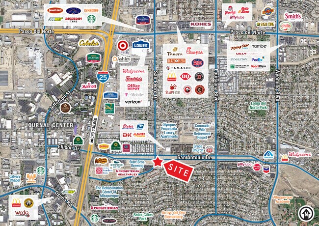
Current Lease Availabilities
NEARBY LISTINGS FOR SALE OR LEASE
Property Detail
San Pedro
Albuquerque, NM
J Group Add
1-018-062-277507-1-02-25
TRACT B-2 J GROUP ADDN PLAT OF TRS B-1A & B-2 J GROUP ADDN C ONT 31,551 SQ FT M/L
Commercialacreage
Bernalillo
X
New Mexico
35001C0137H
0.72 AC
2024
Far Northeast Heights
2025
Albuquerque
003725
DEMOGRAPHICS near San Pedro
1 Mile
3 Mile
5 Mile
2024 Total Population
13,825
98,710
214,633
2029 Population
13,860
98,600
214,262
Pop Growth 2024-2029
+ 0.25%
(0.11%)
(0.17%)
Average Age
45
42
43
2024 Total Households
6,564
43,885
96,164
HH Growth 2024-2029
(0.05%)
(0.16%)
(0.18%)
Median Household Inc
$53,640
$65,054
$66,374
Avg Household Size
2.00
2.20
2.20
2024 Avg HH Vehicles
2.00
2.00
2.00
Median Home Value
$237,223
$308,618
$296,031
Median Year Built
1977
1981
1977
Nearby Places
Map Layers
Map Styles
 Street
 Aerial
- Restaurants
- Banks
- Shops
- Fitness
- Groceries
PUBLIC TRANSPORTATION
COMMUTER RAIL
Los Ranchos-Journal Center (NMRX - Rio Metro Regional Transit District, Rail Runner Express - Rio Metro Regional Transit District)
DRIVE
WALK
Distance
Los Ranchos-Journal Center (NMRX - Rio Metro Regional Transit District, Rail Runner Express - Rio Metro Regional Transit District)
8 min
3.4 mi
Montaño Station (NMRX - Rio Metro Regional Transit District)
DRIVE
WALK
Distance
Montaño Station (NMRX - Rio Metro Regional Transit District)
8 min
4.7 mi
AIRPORT
Albuquerque International Sunport
DRIVE
WALK
Distance
Albuquerque International Sunport
29 min
12.3 mi
Freight Ports
Tulsa Port Of Catoosa
DRIVE
WALK
Distance
Tulsa Port Of Catoosa
692 min
662.5 mi
Nearby Properties
Address
Land Use
TOTAL SIZE
Lot Size
Zoning
Address
Land Use
TOTAL SIZE
Lot Size
Zoning
2,880 SF
162.53 AC
Address
Land Use
TOTAL SIZE
Lot Size
Zoning
380,827 SF
42 AC
Address
Land Use
TOTAL SIZE
Lot Size
Zoning
254,392 SF
40.71 AC
Address
Land Use
TOTAL SIZE
Lot Size
Zoning
17,809 SF
6.58 AC
Address
Land Use
TOTAL SIZE
Lot Size
Zoning
34,585 SF
10.16 AC
Address
Land Use
TOTAL SIZE
Lot Size
Zoning
Address
Land Use
TOTAL SIZE
Lot Size
Zoning
519,680 SF
59.70 AC
Address
Land Use
TOTAL SIZE
Lot Size
Zoning
386,293 SF
44.14 AC
Address
Land Use
TOTAL SIZE
Lot Size
Zoning
406,554 SF
31.72 AC
Address
Land Use
TOTAL SIZE
Lot Size
Zoning
94,696 SF
4.34 AC
Address
Land Use
TOTAL SIZE
Lot Size
Zoning
59,072 SF
17.86 AC
Address
Land Use
TOTAL SIZE
Lot Size
Zoning
165,312 SF
14.86 AC
Address
Land Use
TOTAL SIZE
Lot Size
Zoning
395,175 SF
54.49 AC
Address
Land Use
TOTAL SIZE
Lot Size
Zoning
173,169 SF
45.75 AC
Address
Land Use
TOTAL SIZE
Lot Size
Zoning
20,680 SF
13.99 AC
Address
Land Use
TOTAL SIZE
Lot Size
Zoning
176,357 SF
10.02 AC
Address
Land Use
TOTAL SIZE
Lot Size
Zoning
257,532 SF
3.04 AC
Address
Land Use
TOTAL SIZE
Lot Size
Zoning
Address
Land Use
TOTAL SIZE
Lot Size
Zoning
102,000 SF
4.43 AC
Address
Land Use
TOTAL SIZE
Lot Size
Zoning
11,049 SF
184.54 AC
Address
Land Use
TOTAL SIZE
Lot Size
Zoning
171,279 SF
8.88 AC
Address
Land Use
TOTAL SIZE
Lot Size
Zoning
68,004 SF
9.99 AC
Address
Land Use
TOTAL SIZE
Lot Size
Zoning
26,033 SF
7.28 AC
Address
Land Use
TOTAL SIZE
Lot Size
Zoning
37,232 SF
11.57 AC
Address
Land Use
TOTAL SIZE
Lot Size
Zoning
53,200 SF
21.77 AC
Address
Land Use
TOTAL SIZE
Lot Size
Zoning
66,816 SF
10.89 AC
Address
Land Use
TOTAL SIZE
Lot Size
Zoning
37,771 SF
7.71 AC
Address
Land Use
TOTAL SIZE
Lot Size
Zoning
Address
Land Use
TOTAL SIZE
Lot Size
Zoning
208,496 SF
4.08 AC
The World's #1 Commercial Real Estate Marketplace
Connect with us
© 2026 CoStar Group
The information above has been obtained from sources believed reliable. While we do not doubt its accuracy we have not verified it and make no guarantee, warranty or representation about it. It is your responsibility to independently confirm its accuracy and completeness. Any projections, opinions, assumptions, or estimates used are for example only and do not represent the current or future performance of the property. The value of this transaction to you depends on tax and other factors which should be evaluated by your tax, financial, and legal advisors. You and your advisors should conduct a careful, independent investigation of the property to determine to your satisfaction the suitability of the property for your needs.