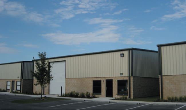
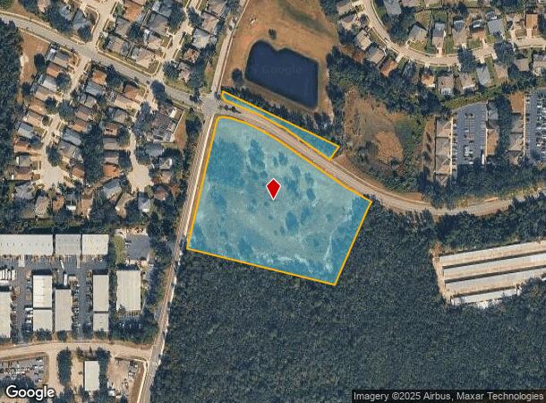
Property Record
399 S Shell Rd, Debary, FL 32713
NEARBY LISTINGS FOR SALE OR LEASE
Property Detail
399 S Shell Rd
Deltona-Daytona Beach-Ormond Beach, FL
Springview Unit 1 Mb
9004-05-00-0050
LOT 5 SPRINGVIEW UNIT 1 MB 47 PGS 60-61 INC PER OR 4494 PG 0269
Commercialacreage
Volusia
X
Florida
12127C0730H
5
2025
6.44 AC
2026
Deltona
090904
Deltona/Daytona Beach
DEMOGRAPHICS near 399 S Shell Rd
1 Mile
3 Mile
5 Mile
2024 Total Population
4,603
24,340
78,586
2029 Population
5,143
27,010
85,744
Pop Growth 2024-2029
+ 11.73%
+ 10.97%
+ 9.11%
Average Age
41
44
41
2024 Total Households
1,768
9,586
30,733
HH Growth 2024-2029
+ 11.88%
+ 11.01%
+ 9.26%
Median Household Inc
$66,657
$75,319
$65,817
Avg Household Size
2.60
2.50
2.50
2024 Avg HH Vehicles
2.00
2.00
2.00
Median Home Value
$248,437
$266,845
$258,420
Median Year Built
1991
1993
1995
Nearby Places
Map Layers
Map Styles
 Street
 Aerial
- Restaurants
- Banks
- Shops
- Fitness
- Groceries
PUBLIC TRANSPORTATION
COMMUTER RAIL
Debary (SunRail - Florida Department of Transportation)
DRIVE
WALK
Distance
Debary (SunRail - Florida Department of Transportation)
3 min
1.4 mi
Sanford (SunRail - Florida Department of Transportation)
DRIVE
WALK
Distance
Sanford (SunRail - Florida Department of Transportation)
12 min
7.0 mi
AIRPORT
Orlando Sanford International
DRIVE
WALK
Distance
Orlando Sanford International
23 min
12.3 mi
Daytona Beach International
DRIVE
WALK
Distance
Daytona Beach International
39 min
30.2 mi
Freight Ports
Port Canaveral
DRIVE
WALK
Distance
Port Canaveral
89 min
73.5 mi
Nearby Properties
Address
Land Use
TOTAL SIZE
Lot Size
Zoning
Address
Land Use
TOTAL SIZE
Lot Size
Zoning
381,678 SF
15.85 AC
Address
Land Use
TOTAL SIZE
Lot Size
Zoning
258,869 SF
38.34 AC
P
Address
Land Use
TOTAL SIZE
Lot Size
Zoning
9,460 SF
208.56 AC
Address
Land Use
TOTAL SIZE
Lot Size
Zoning
158,247 SF
1,708.99 AC
Address
Land Use
TOTAL SIZE
Lot Size
Zoning
11,016 SF
13 AC
01MH1
Address
Land Use
TOTAL SIZE
Lot Size
Zoning
135,845 SF
18.34 AC
Address
Land Use
TOTAL SIZE
Lot Size
Zoning
11,509 SF
10 AC
01MH1
Address
Land Use
TOTAL SIZE
Lot Size
Zoning
44,975 SF
7.98 AC
Address
Land Use
TOTAL SIZE
Lot Size
Zoning
130,665 SF
9.20 AC
01B9
Address
Land Use
TOTAL SIZE
Lot Size
Zoning
44,666 SF
4.77 AC
01B4
Address
Land Use
TOTAL SIZE
Lot Size
Zoning
Address
Land Use
TOTAL SIZE
Lot Size
Zoning
1,850 SF
11.30 AC
C3
Address
Land Use
TOTAL SIZE
Lot Size
Zoning
29.21 AC
M1
Address
Land Use
TOTAL SIZE
Lot Size
Zoning
71,146 SF
3.67 AC
01B
Address
Land Use
TOTAL SIZE
Lot Size
Zoning
71,035 SF
5.03 AC
Address
Land Use
TOTAL SIZE
Lot Size
Zoning
40,578 SF
2.51 AC
01B4
Address
Land Use
TOTAL SIZE
Lot Size
Zoning
48,226 SF
6.92 AC
PCD
Address
Land Use
TOTAL SIZE
Lot Size
Zoning
23,460 SF
5 AC
Address
Land Use
TOTAL SIZE
Lot Size
Zoning
44,638 SF
4.77 AC
Address
Land Use
TOTAL SIZE
Lot Size
Zoning
101,705 SF
7.97 AC
Address
Land Use
TOTAL SIZE
Lot Size
Zoning
66,453 SF
5.30 AC
01R
Address
Land Use
TOTAL SIZE
Lot Size
Zoning
16,030 SF
2.36 AC
Address
Land Use
TOTAL SIZE
Lot Size
Zoning
22,730 SF
0.30 AC
01A2
Address
Land Use
TOTAL SIZE
Lot Size
Zoning
69,387 SF
5.83 AC
01B4
Address
Land Use
TOTAL SIZE
Lot Size
Zoning
33,336 SF
5.92 AC
01A1
Address
Land Use
TOTAL SIZE
Lot Size
Zoning
103,508 SF
10.68 AC
01B5
Address
Land Use
TOTAL SIZE
Lot Size
Zoning
85,414 SF
6.28 AC
M1
Address
Land Use
TOTAL SIZE
Lot Size
Zoning
40,717 SF
4.30 AC
01B
Address
Land Use
TOTAL SIZE
Lot Size
Zoning
17.48 AC
M1
Address
Land Use
TOTAL SIZE
Lot Size
Zoning
37,459 SF
15.33 AC
01R6
The World's #1 Commercial Real Estate Marketplace
Connect with us
© 2026 CoStar Group
The information above has been obtained from sources believed reliable. While we do not doubt its accuracy we have not verified it and make no guarantee, warranty or representation about it. It is your responsibility to independently confirm its accuracy and completeness. Any projections, opinions, assumptions, or estimates used are for example only and do not represent the current or future performance of the property. The value of this transaction to you depends on tax and other factors which should be evaluated by your tax, financial, and legal advisors. You and your advisors should conduct a careful, independent investigation of the property to determine to your satisfaction the suitability of the property for your needs.