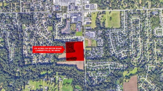
Property Record
Secor Rd, Lambertville, MI 48144

Property Detail
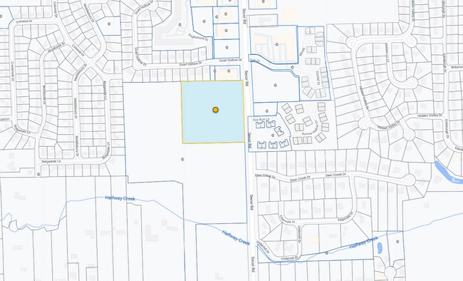
Secor Rd
02-031-004-00
SEC 31 T8S T7E 10 ACRES COM @ A PT ON C/L OF SECOR RD 654.05 FT N 0D 20M W FR E 1/4 COR TH N 0D 20M W 660 FT TH N 89D 55M W
Commercialnec
MONROE
R-2B
Michigan
B and X Area of moderate flood hazard, usually the area between the limits of the 100-year and 500-year floods.
10 AC
2025
Monroe County
2025
Detroit
833100
Monroe, MI
NEARBY LISTINGS FOR SALE OR LEASE
DEMOGRAPHICS near Secor Rd
1 mile
3 mile
5 mile
2025 Total Population
5,319
47,845
127,543
2030 Population
5,277
47,251
125,517
Pop Growth 2025-2030
(0.79%)
(1.24%)
(1.59%)
Average Age
46
43
41
2025 Total Households
2,178
20,158
54,608
HH Growth 2025-2030
(0.73%)
(1.23%)
(1.60%)
Median Household Inc
$102,830
$71,826
$67,163
Avg Household Size
2.40
2.30
2.30
2025 Avg HH Vehicles
2.00
2.00
2.00
Median Home Value
$304,021
$194,901
$174,154
Median Year Built
1984
1968
1961
Nearby Places
Map Layers
Map Styles
 Street
 Aerial
Layers
 Traffic
 Biking
Places
Listings with unknown addresses are not visible on the map
- Restaurants
- Banks
- Shops
- Fitness
- Groceries
PUBLIC TRANSPORTATION
AIRPORT
Eugene F Kranz Toledo Express
Drive
Walk
Distance
Eugene F Kranz Toledo Express
39 min
24.1 mi
Freight Ports
Port of Toledo
Drive
Walk
Distance
Port of Toledo
29 min
15.1 mi
SALE & LEASE HISTORY
LISTING DATE
SALE/LEASE

Sep 24, 2016
For Sale
Nearby Properties
Address
Land Use
TOTAL SIZE
Lot Size
Zoning
Address
Land Use
TOTAL SIZE
Lot Size
Zoning
165,739 SF
17.77 AC
Address
Land Use
TOTAL SIZE
Lot Size
Zoning
76.32 AC
10-IG
Address
Land Use
TOTAL SIZE
Lot Size
Zoning
223,900 SF
17.26 AC
Address
Land Use
TOTAL SIZE
Lot Size
Zoning
293,770 SF
13.95 AC
10-RS6
Address
Land Use
TOTAL SIZE
Lot Size
Zoning
90,113 SF
11.83 AC
10-RS6
Address
Land Use
TOTAL SIZE
Lot Size
Zoning
222,493 SF
29.88 AC
10-IC
Address
Land Use
TOTAL SIZE
Lot Size
Zoning
61,718 SF
7 AC
Address
Land Use
TOTAL SIZE
Lot Size
Zoning
52,429 SF
3.79 AC
10-CO
Address
Land Use
TOTAL SIZE
Lot Size
Zoning
135,978 SF
14.01 AC
31-B2
Address
Land Use
TOTAL SIZE
Lot Size
Zoning
170,528 SF
15 AC
Address
Land Use
TOTAL SIZE
Lot Size
Zoning
78,266 SF
13.57 AC
20-S1
Address
Land Use
TOTAL SIZE
Lot Size
Zoning
54,085 SF
0.81 AC
20-S1
Address
Land Use
TOTAL SIZE
Lot Size
Zoning
41,200 SF
9.45 AC
31-MX
Address
Land Use
TOTAL SIZE
Lot Size
Zoning
64,980 SF
5.80 AC
Address
Land Use
TOTAL SIZE
Lot Size
Zoning
99,366 SF
1.57 AC
10-RS12
Address
Land Use
TOTAL SIZE
Lot Size
Zoning
49,875 SF
3.97 AC
Address
Land Use
TOTAL SIZE
Lot Size
Zoning
18,970 SF
3.72 AC
Address
Land Use
TOTAL SIZE
Lot Size
Zoning
97,790 SF
5 AC
10-RM36
Address
Land Use
TOTAL SIZE
Lot Size
Zoning
53,933 SF
5.26 AC
Address
Land Use
TOTAL SIZE
Lot Size
Zoning
141,196 SF
7.40 AC
10-RM36
Address
Land Use
TOTAL SIZE
Lot Size
Zoning
124,772 SF
4.22 AC
10-IC
Address
Land Use
TOTAL SIZE
Lot Size
Zoning
62,461 SF
5.19 AC
10-RS12
Address
Land Use
TOTAL SIZE
Lot Size
Zoning
48,474 SF
34 AC
10-RS6
Address
Land Use
TOTAL SIZE
Lot Size
Zoning
30,108 SF
4.43 AC
Address
Land Use
TOTAL SIZE
Lot Size
Zoning
54,786 SF
7 AC
10-RS6
Address
Land Use
TOTAL SIZE
Lot Size
Zoning
34,634 SF
37.38 AC
B2
Address
Land Use
TOTAL SIZE
Lot Size
Zoning
10,081 SF
1.61 AC
10-CR
Address
Land Use
TOTAL SIZE
Lot Size
Zoning
53,246 SF
7 AC
10-RS6
Address
Land Use
TOTAL SIZE
Lot Size
Zoning
6,164 SF
124.64 AC
Address
Land Use
TOTAL SIZE
Lot Size
Zoning
125,354 SF
4.14 AC
10-CR
The World's #1 Commercial Real Estate Marketplace
Connect with us
© 2026 CoStar Group
The information above has been obtained from sources believed reliable. While we do not doubt its accuracy we have not verified it and make no guarantee, warranty or representation about it. It is your responsibility to independently confirm its accuracy and completeness. Any projections, opinions, assumptions, or estimates used are for example only and do not represent the current or future performance of the property. The value of this transaction to you depends on tax and other factors which should be evaluated by your tax, financial, and legal advisors. You and your advisors should conduct a careful, independent investigation of the property to determine to your satisfaction the suitability of the property for your needs.