Property Record
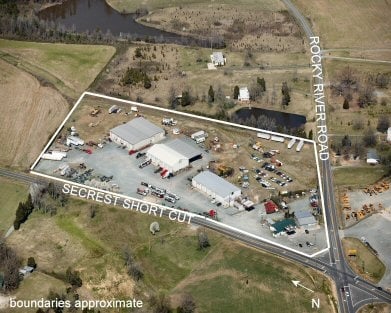
Secrest Shortcut Rd, Indian Trail, NC 28079


Property Detail
Secrest Shortcut Rd
07-012-001
TRACT #1 8068-218
Publicstorage
UNION
GB MONROE
North Carolina
B and X Area of moderate flood hazard, usually the area between the limits of the 100-year and 500-year floods.
9.44 AC
2025
Union County
2025
Charlotte
020321
Charlotte-Concord-Gastonia, NC-SC
15,000 SF
NEARBY LISTINGS FOR SALE OR LEASE
DEMOGRAPHICS near Secrest Shortcut Rd
1 mile
3 mile
5 mile
2025 Total Population
3,386
30,642
79,734
2030 Population
3,728
33,669
87,224
Pop Growth 2025-2030
+ 10.10%
+ 9.88%
+ 9.39%
Average Age
38
38
38
2025 Total Households
1,189
10,540
27,609
HH Growth 2025-2030
+ 10.18%
+ 9.95%
+ 9.52%
Median Household Inc
$89,835
$90,242
$89,377
Avg Household Size
2.80
2.90
2.90
2025 Avg HH Vehicles
2.00
2.00
2.00
Median Home Value
$339,554
$373,945
$377,065
Median Year Built
2003
2002
2001
Nearby Places
Map Layers
Map Styles
 Street
 Aerial
Layers
 Traffic
 Biking
Places
Listings with unknown addresses are not visible on the map
- Restaurants
- Banks
- Shops
- Fitness
- Groceries
PUBLIC TRANSPORTATION
AIRPORT
Charlotte/Douglas International
Drive
Walk
Distance
Charlotte/Douglas International
43 min
27.7 mi
Concord-Padgett Regional
Drive
Walk
Distance
Concord-Padgett Regional
38 min
28.3 mi
Freight Ports
North Charleston Terminal
Drive
Walk
Distance
North Charleston Terminal
230 min
191.2 mi
SALE & LEASE HISTORY
LISTING DATE
SALE/LEASE

Sep 24, 2016
For Sale
May 22, 2017
For Sale
Nearby Properties
Address
Land Use
TOTAL SIZE
Lot Size
Zoning
Address
Land Use
TOTAL SIZE
Lot Size
Zoning
170,725 SF
179.83 AC
RA-40 UNIO
Address
Land Use
TOTAL SIZE
Lot Size
Zoning
27,900 SF
15.59 AC
MFR INDIAN
Address
Land Use
TOTAL SIZE
Lot Size
Zoning
166,254 SF
99.20 AC
G-I MONROE
Address
Land Use
TOTAL SIZE
Lot Size
Zoning
81,504 SF
30.21 AC
CD MONROE
Address
Land Use
TOTAL SIZE
Lot Size
Zoning
83,808 SF
23.45 AC
CD MONROE
Address
Land Use
TOTAL SIZE
Lot Size
Zoning
23.16 AC
CD MONROE
Address
Land Use
TOTAL SIZE
Lot Size
Zoning
11,424 SF
17.71 AC
GB MONROE
Address
Land Use
TOTAL SIZE
Lot Size
Zoning
24.89 AC
Address
Land Use
TOTAL SIZE
Lot Size
Zoning
49,710 SF
14.20 AC
CZ INDIAN
Address
Land Use
TOTAL SIZE
Lot Size
Zoning
159,892 SF
15.84 AC
G-I MONROE
Address
Land Use
TOTAL SIZE
Lot Size
Zoning
103,100 SF
28.55 AC
RBD INDIAN
Address
Land Use
TOTAL SIZE
Lot Size
Zoning
2,968 SF
9.34 AC
R-20 UNION
Address
Land Use
TOTAL SIZE
Lot Size
Zoning
97,318 SF
27.57 AC
RA-40 UNIO
Address
Land Use
TOTAL SIZE
Lot Size
Zoning
79,930 SF
261.95 AC
RBD INDIAN
Address
Land Use
TOTAL SIZE
Lot Size
Zoning
123,296 SF
9.70 AC
CD MONROE
Address
Land Use
TOTAL SIZE
Lot Size
Zoning
45.21 AC
RBD INDIAN
Address
Land Use
TOTAL SIZE
Lot Size
Zoning
13,141 SF
174.76 AC
G-I MONROE
Address
Land Use
TOTAL SIZE
Lot Size
Zoning
45,053 SF
15.03 AC
RBD INDIAN
Address
Land Use
TOTAL SIZE
Lot Size
Zoning
40,291 SF
3.59 AC
CD MONROE
Address
Land Use
TOTAL SIZE
Lot Size
Zoning
246,033 SF
35 AC
G-I MONROE
Address
Land Use
TOTAL SIZE
Lot Size
Zoning
15.33 AC
Address
Land Use
TOTAL SIZE
Lot Size
Zoning
139,853 SF
16.30 AC
RBD INDIAN
Address
Land Use
TOTAL SIZE
Lot Size
Zoning
52,379 SF
2.11 AC
GBD INDIAN
Address
Land Use
TOTAL SIZE
Lot Size
Zoning
40,680 SF
15.13 AC
Address
Land Use
TOTAL SIZE
Lot Size
Zoning
59,060 SF
7.51 AC
CD MONROE
Address
Land Use
TOTAL SIZE
Lot Size
Zoning
9.57 AC
Address
Land Use
TOTAL SIZE
Lot Size
Zoning
174,518 SF
27.54 AC
G-I MONROE
Address
Land Use
TOTAL SIZE
Lot Size
Zoning
30.42 AC
HC UNION C
Address
Land Use
TOTAL SIZE
Lot Size
Zoning
67,674 SF
30 AC
SF-1 INDIA
Address
Land Use
TOTAL SIZE
Lot Size
Zoning
74,932 SF
20.65 AC
R-20 UNION
The World's #1 Commercial Real Estate Marketplace
Connect with us
© 2026 CoStar Group
The information above has been obtained from sources believed reliable. While we do not doubt its accuracy we have not verified it and make no guarantee, warranty or representation about it. It is your responsibility to independently confirm its accuracy and completeness. Any projections, opinions, assumptions, or estimates used are for example only and do not represent the current or future performance of the property. The value of this transaction to you depends on tax and other factors which should be evaluated by your tax, financial, and legal advisors. You and your advisors should conduct a careful, independent investigation of the property to determine to your satisfaction the suitability of the property for your needs.