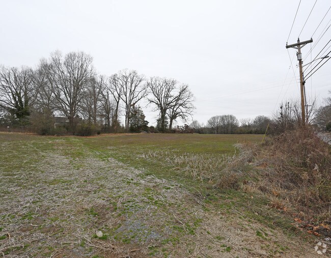
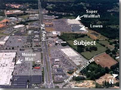
Property Record
2365 Secrest Shortcut Rd, Monroe, NC 28110

NEARBY LISTINGS FOR SALE OR LEASE
Property Detail
2365 Secrest Shortcut Rd
Charlotte-Concord-Gastonia, NC-SC
Property Of Sevs Monroe Associates
09-216-076-B
Union
Sfr
North Carolina
X
23.38 AC
3710543600J
Union County
1,430 SF
Charlotte
DEMOGRAPHICS near 2365 Secrest Shortcut Rd
1 Mile
3 Mile
5 Mile
2024 Total Population
4,014
28,263
55,840
2029 Population
4,577
31,880
63,049
Pop Growth 2024-2029
+ 14.03%
+ 12.80%
+ 12.91%
Average Age
39
38
38
2024 Total Households
1,540
10,173
19,712
HH Growth 2024-2029
+ 14.16%
+ 12.99%
+ 13.07%
Median Household Inc
$63,068
$59,591
$68,771
Avg Household Size
2.60
2.70
2.80
2024 Avg HH Vehicles
2.00
2.00
2.00
Median Home Value
$271,093
$241,170
$263,189
Median Year Built
1990
1988
1993
Nearby Places
Map Layers
Map Styles
 Street
 Aerial
- Restaurants
- Banks
- Shops
- Fitness
- Groceries
PUBLIC TRANSPORTATION
AIRPORT
Charlotte/Douglas International
DRIVE
WALK
Distance
Charlotte/Douglas International
47 min
30.4 mi
Concord-Padgett Regional
DRIVE
WALK
Distance
Concord-Padgett Regional
46 min
34.7 mi
Freight Ports
North Charleston Terminal
DRIVE
WALK
Distance
North Charleston Terminal
224 min
186.5 mi
SALE & LEASE HISTORY
LISTING DATE
SALE/LEASE

Apr 03, 2017
For Sale
Nearby Properties
Address
Land Use
TOTAL SIZE
Lot Size
Zoning
Address
Land Use
TOTAL SIZE
Lot Size
Zoning
148,145 SF
26.68 AC
G-I MONROE
Address
Land Use
TOTAL SIZE
Lot Size
Zoning
78.48 AC
Address
Land Use
TOTAL SIZE
Lot Size
Zoning
30,708 SF
29.10 AC
R-MF MONRO
Address
Land Use
TOTAL SIZE
Lot Size
Zoning
18,208 SF
12.09 AC
R-MF MONRO
Address
Land Use
TOTAL SIZE
Lot Size
Zoning
99,235 SF
1.92 AC
CBD MONROE
Address
Land Use
TOTAL SIZE
Lot Size
Zoning
57,664 SF
45.15 AC
R-20 MONRO
Address
Land Use
TOTAL SIZE
Lot Size
Zoning
81,504 SF
30.21 AC
CD MONROE
Address
Land Use
TOTAL SIZE
Lot Size
Zoning
82.26 AC
G-I MONROE
Address
Land Use
TOTAL SIZE
Lot Size
Zoning
2,048 SF
17.71 AC
GB MONROE
Address
Land Use
TOTAL SIZE
Lot Size
Zoning
24.89 AC
Address
Land Use
TOTAL SIZE
Lot Size
Zoning
71,831 SF
67.94 AC
CD MONROE
Address
Land Use
TOTAL SIZE
Lot Size
Zoning
219,625 SF
36.12 AC
GB MONROE
Address
Land Use
TOTAL SIZE
Lot Size
Zoning
79,493 SF
18.97 AC
CD MONROE
Address
Land Use
TOTAL SIZE
Lot Size
Zoning
62,865 SF
4.87 AC
CD MONROE
Address
Land Use
TOTAL SIZE
Lot Size
Zoning
7,104 SF
11.99 AC
R-MF MONRO
Address
Land Use
TOTAL SIZE
Lot Size
Zoning
54,712 SF
10.01 AC
GB MONROE
Address
Land Use
TOTAL SIZE
Lot Size
Zoning
123,296 SF
9.70 AC
CD MONROE
Address
Land Use
TOTAL SIZE
Lot Size
Zoning
5.89 AC
G-I MONROE
Address
Land Use
TOTAL SIZE
Lot Size
Zoning
40,291 SF
3.59 AC
CD MONROE
Address
Land Use
TOTAL SIZE
Lot Size
Zoning
1,920 SF
9.99 AC
R-MF MONRO
Address
Land Use
TOTAL SIZE
Lot Size
Zoning
14.77 AC
Address
Land Use
TOTAL SIZE
Lot Size
Zoning
6,440 SF
2.23 AC
GB MONROE
Address
Land Use
TOTAL SIZE
Lot Size
Zoning
101,035 SF
26.11 AC
G-I MONROE
Address
Land Use
TOTAL SIZE
Lot Size
Zoning
9,072 SF
15.23 AC
R-MF MONRO
Address
Land Use
TOTAL SIZE
Lot Size
Zoning
3,276 SF
6.20 AC
R-MF MONRO
Address
Land Use
TOTAL SIZE
Lot Size
Zoning
63,813 SF
1.95 AC
GB MONROE
Address
Land Use
TOTAL SIZE
Lot Size
Zoning
59,060 SF
7.51 AC
CD MONROE
Address
Land Use
TOTAL SIZE
Lot Size
Zoning
9.57 AC
Address
Land Use
TOTAL SIZE
Lot Size
Zoning
65,515 SF
27.66 AC
G-I MONROE
Address
Land Use
TOTAL SIZE
Lot Size
Zoning
41,820 SF
6.23 AC
G-I MONROE
The World's #1 Commercial Real Estate Marketplace
Connect with us
© 2026 CoStar Group
The information above has been obtained from sources believed reliable. While we do not doubt its accuracy we have not verified it and make no guarantee, warranty or representation about it. It is your responsibility to independently confirm its accuracy and completeness. Any projections, opinions, assumptions, or estimates used are for example only and do not represent the current or future performance of the property. The value of this transaction to you depends on tax and other factors which should be evaluated by your tax, financial, and legal advisors. You and your advisors should conduct a careful, independent investigation of the property to determine to your satisfaction the suitability of the property for your needs.