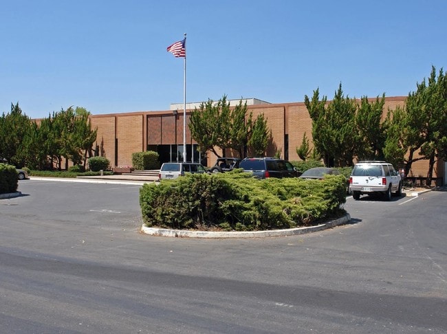
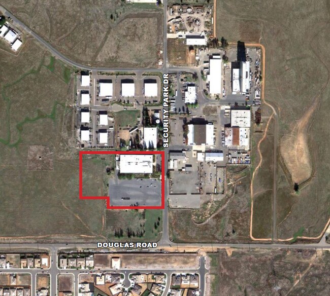
Property Record
3978 Security Park Dr, Rancho Cordova, CA 95742

NEARBY LISTINGS FOR SALE OR LEASE
-
-
-
-
-
Rancho Cordova Pky @ International Dr
Rancho Cordova, CA 95742
Negotiable
211,480 - 564,440 SF
Industrial
-
-
View all Rancho Cordova listings for lease on LoopNet.com
Property Detail
3978 Security Park Dr
Sacramento--Roseville--Arden-Arcade, CA
PARCEL MAP BOOK 127 PAGE 10 LOT 1
072-0370-087
Sacramento
Industrialacreage
California
X
1
06067C0240J
4.10 AC
2024
Sunrise
2025
Sacramento
008706
DEMOGRAPHICS near 3978 Security Park Dr
1 Mile
3 Mile
5 Mile
2024 Total Population
5,178
17,217
43,044
2029 Population
5,234
17,534
43,544
Pop Growth 2024-2029
+ 1.08%
+ 1.84%
+ 1.16%
Average Age
37
36
38
2024 Total Households
1,668
5,042
14,933
HH Growth 2024-2029
+ 0.96%
+ 1.80%
+ 1.07%
Median Household Inc
$159,085
$154,528
$115,442
Avg Household Size
3.10
3.30
2.80
2024 Avg HH Vehicles
2.00
2.00
2.00
Median Home Value
$596,643
$588,235
$522,035
Median Year Built
2010
2010
2002
Nearby Places
- Restaurants
- Banks
- Shops
- Fitness
- Groceries
PUBLIC TRANSPORTATION
AIRPORT
Sacramento International
DRIVE
WALK
Distance
Sacramento International
42 min
30.7 mi
Freight Ports
Port of Stockton
DRIVE
WALK
Distance
Port of Stockton
71 min
52.7 mi
SALE & LEASE HISTORY
LISTING DATE
SALE/LEASE

Nov 11, 2025
For Lease
Dec 11, 2023
For Lease
Dec 11, 2023
For Sale
Nearby Properties
Address
Land Use
TOTAL SIZE
Lot Size
Zoning
Address
Land Use
TOTAL SIZE
Lot Size
Zoning
83.57 AC
MP (RDOSP)
Address
Land Use
TOTAL SIZE
Lot Size
Zoning
RD 7 (SDSP
Address
Land Use
TOTAL SIZE
Lot Size
Zoning
582.63 AC
SF (RDOSP)
Address
Land Use
TOTAL SIZE
Lot Size
Zoning
43,185 SF
3.38 AC
GC
Address
Land Use
TOTAL SIZE
Lot Size
Zoning
39.08 AC
MP (RDOSP)
Address
Land Use
TOTAL SIZE
Lot Size
Zoning
82,688 SF
5 AC
M-1
Address
Land Use
TOTAL SIZE
Lot Size
Zoning
401.20 AC
DP (RDOSP)
Address
Land Use
TOTAL SIZE
Lot Size
Zoning
28,000 SF
7.48 AC
M-2
Address
Land Use
TOTAL SIZE
Lot Size
Zoning
14,820 SF
2.36 AC
GC
Address
Land Use
TOTAL SIZE
Lot Size
Zoning
1.71 AC
GC
Address
Land Use
TOTAL SIZE
Lot Size
Zoning
1.70 AC
GC
Address
Land Use
TOTAL SIZE
Lot Size
Zoning
1.04 AC
GC
Address
Land Use
TOTAL SIZE
Lot Size
Zoning
4,417 SF
1.16 AC
GC
Address
Land Use
TOTAL SIZE
Lot Size
Zoning
452,000 SF
2.46 AC
M-2 (SSSPA
Address
Land Use
TOTAL SIZE
Lot Size
Zoning
78,100 SF
5.33 AC
M-1
Address
Land Use
TOTAL SIZE
Lot Size
Zoning
Address
Land Use
TOTAL SIZE
Lot Size
Zoning
1,064 SF
1.99 AC
M-1
Address
Land Use
TOTAL SIZE
Lot Size
Zoning
38,400 SF
5 AC
M-2
Address
Land Use
TOTAL SIZE
Lot Size
Zoning
15,268 SF
9.42 AC
M-2
Address
Land Use
TOTAL SIZE
Lot Size
Zoning
11.76 AC
GC
Address
Land Use
TOTAL SIZE
Lot Size
Zoning
10,446 SF
1.88 AC
GC
Address
Land Use
TOTAL SIZE
Lot Size
Zoning
404.89 AC
M-2 (SM) M
Address
Land Use
TOTAL SIZE
Lot Size
Zoning
9,495 SF
1.66 AC
GC
Address
Land Use
TOTAL SIZE
Lot Size
Zoning
7,500 SF
3.37 AC
M-2
Address
Land Use
TOTAL SIZE
Lot Size
Zoning
11,200 SF
1.24 AC
M-2 (SSSPA
Address
Land Use
TOTAL SIZE
Lot Size
Zoning
BP (RDOSP)
Address
Land Use
TOTAL SIZE
Lot Size
Zoning
10,000 SF
1.86 AC
M-2 (SSSPA
Address
Land Use
TOTAL SIZE
Lot Size
Zoning
15,880 SF
1.12 AC
M-2
Address
Land Use
TOTAL SIZE
Lot Size
Zoning
1,616 SF
80 AC
LDR (SCSP)
Address
Land Use
TOTAL SIZE
Lot Size
Zoning
6.79 AC
RD 20
The World's #1 Commercial Real Estate Marketplace
Connect with us
© 2025 CoStar Group
The information above has been obtained from sources believed reliable. While we do not doubt its accuracy we have not verified it and make no guarantee, warranty or representation about it. It is your responsibility to independently confirm its accuracy and completeness. Any projections, opinions, assumptions, or estimates used are for example only and do not represent the current or future performance of the property. The value of this transaction to you depends on tax and other factors which should be evaluated by your tax, financial, and legal advisors. You and your advisors should conduct a careful, independent investigation of the property to determine to your satisfaction the suitability of the property for your needs.