Property Record
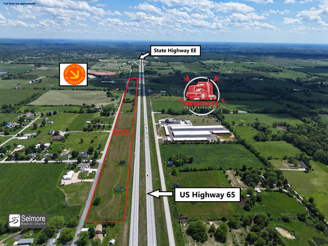
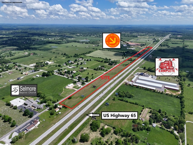
Selmore Rd, Ozark, MO 65721
NEARBY LISTINGS FOR SALE OR LEASE
-
-
View all Ozark listings for sale on LoopNet.com
Property Detail
Selmore Rd
18-0.2-09-000-000-009.000
Ozark Out
Agriculturalland
S1/2 NE1/4 SE1/4, SE1/4 SE1/4, ALL LY E OF H/W 65 & W OF OLD 65
X
Christian
29043C0230D
Missouri
2023
8.20 AC
2024
East Christian County
020304
Springfield
720 SF
Springfield, MO
DEMOGRAPHICS near Selmore Rd
1 Mile
3 Mile
5 Mile
2024 Total Population
287
5,049
21,377
2029 Population
342
6,038
25,618
Pop Growth 2024-2029
+ 19.16%
+ 19.59%
+ 19.84%
Average Age
43
41
40
2024 Total Households
105
1,871
7,933
HH Growth 2024-2029
+ 20.00%
+ 19.67%
+ 19.93%
Median Household Inc
$64,772
$59,878
$65,151
Avg Household Size
2.70
2.70
2.60
2024 Avg HH Vehicles
2.00
2.00
2.00
Median Home Value
$309,091
$263,986
$213,215
Median Year Built
1998
1998
1995
Nearby Places
Map Layers
Map Styles
 Street
 Aerial
- Restaurants
- Banks
- Shops
- Fitness
- Groceries
PUBLIC TRANSPORTATION
AIRPORT
Springfield-Branson Ntl
DRIVE
WALK
Distance
Springfield-Branson Ntl
50 min
35.9 mi
Freight Ports
Tulsa Port of Inola
DRIVE
WALK
Distance
Tulsa Port of Inola
214 min
190.4 mi
SALE & LEASE HISTORY
LISTING DATE
SALE/LEASE

May 15, 2025
For Sale
Nearby Properties
Address
Land Use
TOTAL SIZE
Lot Size
Zoning
Address
Land Use
TOTAL SIZE
Lot Size
Zoning
28.40 AC
Address
Land Use
TOTAL SIZE
Lot Size
Zoning
7,328 SF
2.81 AC
Address
Land Use
TOTAL SIZE
Lot Size
Zoning
25,243 SF
16.92 AC
Address
Land Use
TOTAL SIZE
Lot Size
Zoning
29,782 SF
1.10 AC
Address
Land Use
TOTAL SIZE
Lot Size
Zoning
12,120 SF
0.96 AC
Address
Land Use
TOTAL SIZE
Lot Size
Zoning
15,000 SF
1.73 AC
Address
Land Use
TOTAL SIZE
Lot Size
Zoning
9,328 SF
0.92 AC
Address
Land Use
TOTAL SIZE
Lot Size
Zoning
7,500 SF
9.10 AC
Address
Land Use
TOTAL SIZE
Lot Size
Zoning
18,000 SF
1.09 AC
Address
Land Use
TOTAL SIZE
Lot Size
Zoning
37,888 SF
7 AC
Address
Land Use
TOTAL SIZE
Lot Size
Zoning
400 SF
79 AC
Address
Land Use
TOTAL SIZE
Lot Size
Zoning
2,000 SF
9.10 AC
Address
Land Use
TOTAL SIZE
Lot Size
Zoning
7,276 SF
1.49 AC
Address
Land Use
TOTAL SIZE
Lot Size
Zoning
0.75 AC
Address
Land Use
TOTAL SIZE
Lot Size
Zoning
5.19 AC
Address
Land Use
TOTAL SIZE
Lot Size
Zoning
4,466 SF
2.94 AC
Address
Land Use
TOTAL SIZE
Lot Size
Zoning
6,872 SF
0.63 AC
Address
Land Use
TOTAL SIZE
Lot Size
Zoning
3,600 SF
2.28 AC
Address
Land Use
TOTAL SIZE
Lot Size
Zoning
21,474 SF
9.55 AC
Address
Land Use
TOTAL SIZE
Lot Size
Zoning
12,566 SF
1.85 AC
Address
Land Use
TOTAL SIZE
Lot Size
Zoning
7,276 SF
1.08 AC
Address
Land Use
TOTAL SIZE
Lot Size
Zoning
7,200 SF
1.70 AC
Address
Land Use
TOTAL SIZE
Lot Size
Zoning
21,150 SF
1.20 AC
Address
Land Use
TOTAL SIZE
Lot Size
Zoning
2,000 SF
9.47 AC
Address
Land Use
TOTAL SIZE
Lot Size
Zoning
10,648 SF
78.38 AC
Address
Land Use
TOTAL SIZE
Lot Size
Zoning
14,200 SF
1 AC
Address
Land Use
TOTAL SIZE
Lot Size
Zoning
8,608 SF
2 AC
Address
Land Use
TOTAL SIZE
Lot Size
Zoning
Address
Land Use
TOTAL SIZE
Lot Size
Zoning
3,600 SF
0.55 AC
Address
Land Use
TOTAL SIZE
Lot Size
Zoning
6,864 SF
0.59 AC
The World's #1 Commercial Real Estate Marketplace
Connect with us
© 2025 CoStar Group
The information above has been obtained from sources believed reliable. While we do not doubt its accuracy we have not verified it and make no guarantee, warranty or representation about it. It is your responsibility to independently confirm its accuracy and completeness. Any projections, opinions, assumptions, or estimates used are for example only and do not represent the current or future performance of the property. The value of this transaction to you depends on tax and other factors which should be evaluated by your tax, financial, and legal advisors. You and your advisors should conduct a careful, independent investigation of the property to determine to your satisfaction the suitability of the property for your needs.