Property Record
Selvitz Rd, Fort Pierce, FL 34981
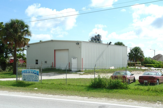


Property Detail
Selvitz Rd
24-32-222-0002-0009
32 35 40 N 200 FT OF W 343.65 FT OF NW 1/4 LYG E OF SELVITZ RD (1.02 AC)
Warehouse
ST LUCIE
INDUST HEA
Florida
B and X Area of moderate flood hazard, usually the area between the limits of the 100-year and 500-year floods.
1.02 AC
2024
Fort Pierce
2025
Port St Lucie/Fort Pierce
381402
Port St. Lucie, FL
2,400 SF
NEARBY LISTINGS FOR SALE OR LEASE
DEMOGRAPHICS near Selvitz Rd
1 mile
3 mile
5 mile
2025 Total Population
1,443
39,405
108,108
2030 Population
1,680
45,274
123,900
Pop Growth 2025-2030
+ 16.42%
+ 14.89%
+ 14.61%
Average Age
39
39
40
2025 Total Households
497
14,632
40,249
HH Growth 2025-2030
+ 16.10%
+ 14.91%
+ 14.52%
Median Household Inc
$71,499
$61,662
$57,115
Avg Household Size
2.70
2.60
2.60
2025 Avg HH Vehicles
2.00
2.00
2.00
Median Home Value
$490,666
$359,456
$352,689
Median Year Built
1999
1993
1990
Nearby Places
Map Layers
Map Styles
 Street
 Aerial
Layers
 Traffic
 Biking
Places
Listings with unknown addresses are not visible on the map
- Restaurants
- Banks
- Shops
- Fitness
- Groceries
Nearby Properties
Address
Land Use
TOTAL SIZE
Lot Size
Zoning
Address
Land Use
TOTAL SIZE
Lot Size
Zoning
1,011,160 SF
129.52 AC
COMM PARKW
Address
Land Use
TOTAL SIZE
Lot Size
Zoning
206,371 SF
22.36 AC
OFFICE CO
Address
Land Use
TOTAL SIZE
Lot Size
Zoning
1,124,770 SF
201.84 AC
LIGHT INDU
Address
Land Use
TOTAL SIZE
Lot Size
Zoning
230,294 SF
40.59 AC
Address
Land Use
TOTAL SIZE
Lot Size
Zoning
352,224 SF
52.44 AC
SF INTERME
Address
Land Use
TOTAL SIZE
Lot Size
Zoning
95,390 SF
19.40 AC
HIGH DESIT
Address
Land Use
TOTAL SIZE
Lot Size
Zoning
150,004 SF
29.19 AC
GENERAL CO
Address
Land Use
TOTAL SIZE
Lot Size
Zoning
149,072 SF
33.27 AC
MEDIUM DEN
Address
Land Use
TOTAL SIZE
Lot Size
Zoning
119,847 SF
12.48 AC
GENERAL CO
Address
Land Use
TOTAL SIZE
Lot Size
Zoning
221,304 SF
12.71 AC
COMM PARKW
Address
Land Use
TOTAL SIZE
Lot Size
Zoning
114,420 SF
22.25 AC
PUD
Address
Land Use
TOTAL SIZE
Lot Size
Zoning
54,810 SF
10.14 AC
GENERAL CO
Address
Land Use
TOTAL SIZE
Lot Size
Zoning
128,427 SF
25.89 AC
MEDIUM DEN
Address
Land Use
TOTAL SIZE
Lot Size
Zoning
66,153 SF
24.36 AC
GENERAL &
Address
Land Use
TOTAL SIZE
Lot Size
Zoning
204,977 SF
28.45 AC
GENERAL CO
Address
Land Use
TOTAL SIZE
Lot Size
Zoning
425,404 SF
189.99 AC
INDUST HEA
Address
Land Use
TOTAL SIZE
Lot Size
Zoning
251,724 SF
30.80 AC
GENERAL CO
Address
Land Use
TOTAL SIZE
Lot Size
Zoning
106,711 SF
16.73 AC
PUD
Address
Land Use
TOTAL SIZE
Lot Size
Zoning
24,696 SF
18.41 AC
GENERAL CO
Address
Land Use
TOTAL SIZE
Lot Size
Zoning
42,794 SF
2.60 AC
GENERAL CO
Address
Land Use
TOTAL SIZE
Lot Size
Zoning
42,150 SF
3.23 AC
GENERAL CO
Address
Land Use
TOTAL SIZE
Lot Size
Zoning
23,278 SF
2.67 AC
GENERAL CO
Address
Land Use
TOTAL SIZE
Lot Size
Zoning
426,444 SF
180.62 AC
INDUST HEA
Address
Land Use
TOTAL SIZE
Lot Size
Zoning
8,312 SF
109.46 AC
COMM PARKW
Address
Land Use
TOTAL SIZE
Lot Size
Zoning
143.81 AC
INDUST HEA
Address
Land Use
TOTAL SIZE
Lot Size
Zoning
66,333 SF
9.88 AC
PUD
Address
Land Use
TOTAL SIZE
Lot Size
Zoning
76,783 SF
9.48 AC
INDUSTRIAL
Address
Land Use
TOTAL SIZE
Lot Size
Zoning
58,331 SF
11.31 AC
MEDIUM DEN
Address
Land Use
TOTAL SIZE
Lot Size
Zoning
155,994 SF
25.13 AC
Address
Land Use
TOTAL SIZE
Lot Size
Zoning
115,443 SF
23.83 AC
SF INTERME
The World's #1 Commercial Real Estate Marketplace
Connect with us
© 2026 CoStar Group
The information above has been obtained from sources believed reliable. While we do not doubt its accuracy we have not verified it and make no guarantee, warranty or representation about it. It is your responsibility to independently confirm its accuracy and completeness. Any projections, opinions, assumptions, or estimates used are for example only and do not represent the current or future performance of the property. The value of this transaction to you depends on tax and other factors which should be evaluated by your tax, financial, and legal advisors. You and your advisors should conduct a careful, independent investigation of the property to determine to your satisfaction the suitability of the property for your needs.