Property Record
Senoia Rd, Fairburn, GA 30213
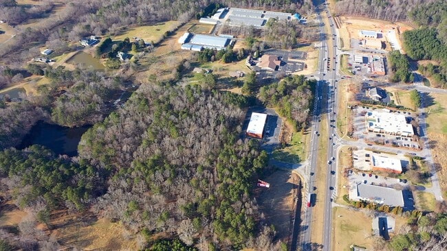
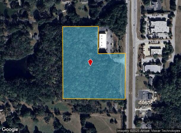
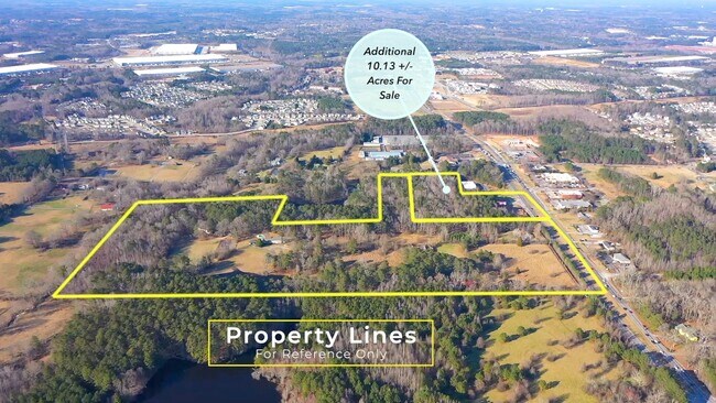
This Property Is For Sale
NEARBY LISTINGS FOR SALE OR LEASE
Property Detail
Senoia Rd
09F-0203-0008-026-7
Fulton
Commercialacreage
Georgia
X
10.13 AC
13121C0464F
North Clayton/Airport
2024
Atlanta
2025
Atlanta-Sandy Springs-Roswell, GA
010535
DEMOGRAPHICS near Senoia Rd
1 Mile
3 Mile
5 Mile
2024 Total Population
5,484
21,501
68,363
2029 Population
5,706
22,325
71,322
Pop Growth 2024-2029
+ 4.05%
+ 3.83%
+ 4.33%
Average Age
34
36
38
2024 Total Households
2,027
7,882
25,009
HH Growth 2024-2029
+ 3.55%
+ 3.68%
+ 4.30%
Median Household Inc
$61,017
$68,171
$64,186
Avg Household Size
2.70
2.70
2.70
2024 Avg HH Vehicles
2.00
2.00
2.00
Median Home Value
$166,502
$208,659
$228,908
Median Year Built
2002
2002
2000
Nearby Places
- Restaurants
- Banks
- Shops
- Fitness
- Groceries
PUBLIC TRANSPORTATION
AIRPORT
Hartsfield - Jackson Atlanta International
DRIVE
WALK
Distance
Hartsfield - Jackson Atlanta International
24 min
16.3 mi
Freight Ports
Georgia Ports - Savannah
DRIVE
WALK
Distance
Georgia Ports - Savannah
286 min
253.6 mi
Nearby Properties
Address
Land Use
TOTAL SIZE
Lot Size
Zoning
Address
Land Use
TOTAL SIZE
Lot Size
Zoning
79.51 AC
AG1
Address
Land Use
TOTAL SIZE
Lot Size
Zoning
1,511,212 SF
19.33 AC
M1
Address
Land Use
TOTAL SIZE
Lot Size
Zoning
1,160,240 SF
71.94 AC
AG1
Address
Land Use
TOTAL SIZE
Lot Size
Zoning
907,675 SF
73.12 AC
AG1
Address
Land Use
TOTAL SIZE
Lot Size
Zoning
1,102,504 SF
24.79 AC
A
Address
Land Use
TOTAL SIZE
Lot Size
Zoning
1,776,355 SF
13.40 AC
PD
Address
Land Use
TOTAL SIZE
Lot Size
Zoning
1,127,500 SF
89.15 AC
M1
Address
Land Use
TOTAL SIZE
Lot Size
Zoning
1,040,000 SF
74.64 AC
AG1
Address
Land Use
TOTAL SIZE
Lot Size
Zoning
831,160 SF
17.53 AC
C2
Address
Land Use
TOTAL SIZE
Lot Size
Zoning
873,600 SF
65.24 AC
C2
Address
Land Use
TOTAL SIZE
Lot Size
Zoning
798,272 SF
18.32 AC
M1A
Address
Land Use
TOTAL SIZE
Lot Size
Zoning
412,253 SF
134.50 AC
Address
Land Use
TOTAL SIZE
Lot Size
Zoning
1,271,815 SF
26.11 AC
C1
Address
Land Use
TOTAL SIZE
Lot Size
Zoning
705,528 SF
62.98 AC
M1
Address
Land Use
TOTAL SIZE
Lot Size
Zoning
1,050,936 SF
26.33 AC
C1
Address
Land Use
TOTAL SIZE
Lot Size
Zoning
556,800 SF
32.69 AC
M1
Address
Land Use
TOTAL SIZE
Lot Size
Zoning
384,305 SF
15.26 AC
MIX
Address
Land Use
TOTAL SIZE
Lot Size
Zoning
498,274 SF
24.34 AC
MIA
Address
Land Use
TOTAL SIZE
Lot Size
Zoning
510,180 SF
41.23 AC
M1
Address
Land Use
TOTAL SIZE
Lot Size
Zoning
715,114 SF
135.23 AC
M2
Address
Land Use
TOTAL SIZE
Lot Size
Zoning
491,992 SF
48.25 AC
M1
Address
Land Use
TOTAL SIZE
Lot Size
Zoning
420,000 SF
23.69 AC
MIA
Address
Land Use
TOTAL SIZE
Lot Size
Zoning
23 AC
AG1
Address
Land Use
TOTAL SIZE
Lot Size
Zoning
368,555 SF
16.03 AC
M1A
Address
Land Use
TOTAL SIZE
Lot Size
Zoning
375,700 SF
19.72 AC
M1
Address
Land Use
TOTAL SIZE
Lot Size
Zoning
317,520 SF
29.74 AC
M1
Address
Land Use
TOTAL SIZE
Lot Size
Zoning
163,142 SF
234.58 AC
M1
Address
Land Use
TOTAL SIZE
Lot Size
Zoning
350,434 SF
23.62 AC
M1
Address
Land Use
TOTAL SIZE
Lot Size
Zoning
388,000 SF
40.74 AC
M1
Address
Land Use
TOTAL SIZE
Lot Size
Zoning
350,000 SF
17.54 AC
M1
The World's #1 Commercial Real Estate Marketplace
Connect with us
© 2025 CoStar Group
The information above has been obtained from sources believed reliable. While we do not doubt its accuracy we have not verified it and make no guarantee, warranty or representation about it. It is your responsibility to independently confirm its accuracy and completeness. Any projections, opinions, assumptions, or estimates used are for example only and do not represent the current or future performance of the property. The value of this transaction to you depends on tax and other factors which should be evaluated by your tax, financial, and legal advisors. You and your advisors should conduct a careful, independent investigation of the property to determine to your satisfaction the suitability of the property for your needs.