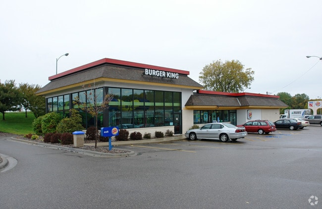
Property Record
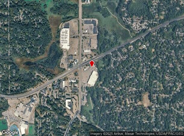
17555 Highway 7, Minnetonka, MN 55345
NEARBY LISTINGS FOR SALE OR LEASE
Property Detail
17555 Highway 7
29-117-22-23-0004
Unplatted 29 117 22
Commercialnec
UNPLATTED 29 117 22 COM AT A PT IN S LINE OF NW 1/4 DIS 743 FT E FROM SW COR THOF TH N 6 DEG 12 MIN W TO A PT 150 FT SELY AT R/A FROM SELY LINE OF HWY T IRREGULAR
AE
Hennepin
27019C0117D
Minnesota
2024
2.87 AC
2024
Ridgedale
026205
Minneapolis/St Paul
4,170 SF
Minneapolis-St. Paul-Bloomington, MN-WI
DEMOGRAPHICS near 17555 Highway 7
1 Mile
3 Mile
5 Mile
2024 Total Population
6,003
43,471
124,616
2029 Population
5,873
42,774
124,420
Pop Growth 2024-2029
(2.17%)
(1.60%)
(0.16%)
Average Age
42
43
43
2024 Total Households
2,332
16,625
51,902
HH Growth 2024-2029
(2.27%)
(1.83%)
(0.26%)
Median Household Inc
$122,784
$129,767
$110,520
Avg Household Size
2.50
2.60
2.30
2024 Avg HH Vehicles
2.00
2.00
2.00
Median Home Value
$416,913
$451,909
$450,633
Median Year Built
1970
1976
1982
Nearby Places
- Restaurants
- Banks
- Shops
- Fitness
- Groceries
PUBLIC TRANSPORTATION
AIRPORT
Minneapolis-St Paul International/Wold-Chamberlain
DRIVE
WALK
Distance
Minneapolis-St Paul International/Wold-Chamberlain
27 min
18.7 mi
Freight Ports
Port Milwaukee
DRIVE
WALK
Distance
Port Milwaukee
395 min
352.5 mi
SALE & LEASE HISTORY
LISTING DATE
SALE/LEASE

Sep 21, 2020
For Lease
Nearby Properties
Address
Land Use
TOTAL SIZE
Lot Size
Zoning
Address
Land Use
TOTAL SIZE
Lot Size
Zoning
171,900 SF
39.17 AC
B1
Address
Land Use
TOTAL SIZE
Lot Size
Zoning
46,726 SF
2.65 AC
PUD
Address
Land Use
TOTAL SIZE
Lot Size
Zoning
20.18 AC
RM65
Address
Land Use
TOTAL SIZE
Lot Size
Zoning
7.06 AC
PUD
Address
Land Use
TOTAL SIZE
Lot Size
Zoning
49,925 SF
18.37 AC
B1
Address
Land Use
TOTAL SIZE
Lot Size
Zoning
7,209 SF
2.53 AC
B1
Address
Land Use
TOTAL SIZE
Lot Size
Zoning
177,644 SF
10.49 AC
I1
Address
Land Use
TOTAL SIZE
Lot Size
Zoning
29,091 SF
34.94 AC
PUD
Address
Land Use
TOTAL SIZE
Lot Size
Zoning
7.82 AC
R4
Address
Land Use
TOTAL SIZE
Lot Size
Zoning
17.67 AC
R4
Address
Land Use
TOTAL SIZE
Lot Size
Zoning
9.29 AC
R4
Address
Land Use
TOTAL SIZE
Lot Size
Zoning
88,948 SF
10.14 AC
B2
Address
Land Use
TOTAL SIZE
Lot Size
Zoning
14.04 AC
R4
Address
Land Use
TOTAL SIZE
Lot Size
Zoning
152,823 SF
12.14 AC
I1
Address
Land Use
TOTAL SIZE
Lot Size
Zoning
38,825 SF
5.38 AC
B3
Address
Land Use
TOTAL SIZE
Lot Size
Zoning
47,485 SF
2.19 AC
PUD
Address
Land Use
TOTAL SIZE
Lot Size
Zoning
1,000 SF
14 AC
Address
Land Use
TOTAL SIZE
Lot Size
Zoning
120,709 SF
16.47 AC
I1
Address
Land Use
TOTAL SIZE
Lot Size
Zoning
12,993 SF
2.22 AC
R5
Address
Land Use
TOTAL SIZE
Lot Size
Zoning
Address
Land Use
TOTAL SIZE
Lot Size
Zoning
Address
Land Use
TOTAL SIZE
Lot Size
Zoning
123,472 SF
9.07 AC
B2
Address
Land Use
TOTAL SIZE
Lot Size
Zoning
104,969 SF
8.09 AC
I1
Address
Land Use
TOTAL SIZE
Lot Size
Zoning
3.20 AC
Address
Land Use
TOTAL SIZE
Lot Size
Zoning
72,936 SF
8.68 AC
I-2
Address
Land Use
TOTAL SIZE
Lot Size
Zoning
18,302 SF
3.52 AC
PUD
Address
Land Use
TOTAL SIZE
Lot Size
Zoning
28,134 SF
2.70 AC
PUD
Address
Land Use
TOTAL SIZE
Lot Size
Zoning
62,862 SF
7.91 AC
B2
Address
Land Use
TOTAL SIZE
Lot Size
Zoning
21,208 SF
3.59 AC
B1
Address
Land Use
TOTAL SIZE
Lot Size
Zoning
63,102 SF
4.88 AC
PUD
The World's #1 Commercial Real Estate Marketplace
Connect with us
© 2025 CoStar Group
The information above has been obtained from sources believed reliable. While we do not doubt its accuracy we have not verified it and make no guarantee, warranty or representation about it. It is your responsibility to independently confirm its accuracy and completeness. Any projections, opinions, assumptions, or estimates used are for example only and do not represent the current or future performance of the property. The value of this transaction to you depends on tax and other factors which should be evaluated by your tax, financial, and legal advisors. You and your advisors should conduct a careful, independent investigation of the property to determine to your satisfaction the suitability of the property for your needs.