Property Record
Sh114 John Day Rd Swc, Haslet, TX 76052
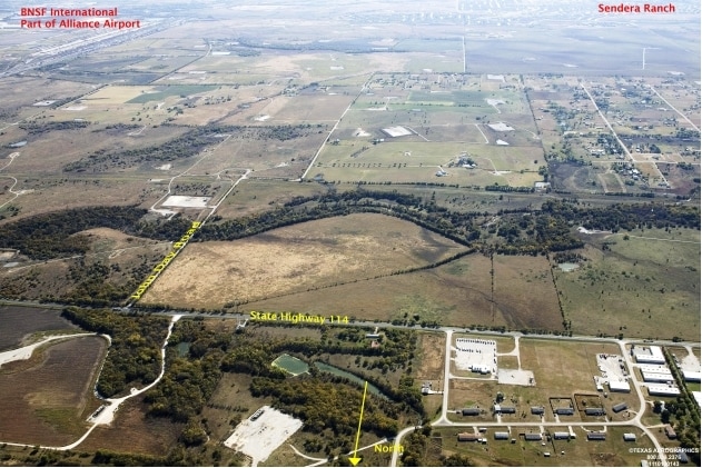
Property Detail
Sh114 John Day Rd Swc
Dallas-Fort Worth-Arlington, TX
A0712A J. KING, TR 1C, 0.202 ACRES
R112440
DENTON
Agriculturalland
Texas
AE The base floodplain where base flood elevations are provided. AE Zones are now used on new format FIRMs instead of A1-A30 Zones.
44.58 AC
2024
Alliance
2025
Dallas/Ft Worth
020320
NEARBY LISTINGS FOR SALE OR LEASE
-
-
View all Haslet listings for sale on LoopNet.com
DEMOGRAPHICS near Sh114 John Day Rd Swc
1 mile
3 mile
5 mile
2025 Total Population
2,812
16,012
47,021
2030 Population
3,388
19,038
53,806
Pop Growth 2025-2030
+ 20.48%
+ 18.90%
+ 14.43%
Average Age
38
35
35
2025 Total Households
896
5,067
14,682
HH Growth 2025-2030
+ 20.65%
+ 19.14%
+ 14.75%
Median Household Inc
$123,832
$146,631
$137,095
Avg Household Size
3.00
3.10
3.20
2025 Avg HH Vehicles
3.00
3.00
2.00
Median Home Value
$553,763
$390,708
$393,917
Median Year Built
2011
2011
2010
Nearby Places
Map Layers
Map Styles
 Street
 Aerial
Layers
 Traffic
 Biking
Places
Listings with unknown addresses are not visible on the map
- Restaurants
- Banks
- Shops
- Fitness
- Groceries
PUBLIC TRANSPORTATION
AIRPORT
Dallas-Fort Worth International
Drive
Walk
Distance
Dallas-Fort Worth International
33 min
25.8 mi
Freight Ports
Port of Shreveport
Drive
Walk
Distance
Port of Shreveport
261 min
239.4 mi
Nearby Properties
Address
Land Use
TOTAL SIZE
Lot Size
Zoning
Address
Land Use
TOTAL SIZE
Lot Size
Zoning
830,399 SF
11.02 AC
Address
Land Use
TOTAL SIZE
Lot Size
Zoning
1,228,350 SF
64.51 AC
Address
Land Use
TOTAL SIZE
Lot Size
Zoning
1,179,900 SF
73.58 AC
Address
Land Use
TOTAL SIZE
Lot Size
Zoning
1,030,050 SF
95.93 AC
Address
Land Use
TOTAL SIZE
Lot Size
Zoning
1,071,600 SF
74.77 AC
Address
Land Use
TOTAL SIZE
Lot Size
Zoning
1,075,256 SF
127.44 AC
Address
Land Use
TOTAL SIZE
Lot Size
Zoning
1,004,400 SF
90.50 AC
Address
Land Use
TOTAL SIZE
Lot Size
Zoning
804,270 SF
58.79 AC
Address
Land Use
TOTAL SIZE
Lot Size
Zoning
714,000 SF
39.12 AC
Address
Land Use
TOTAL SIZE
Lot Size
Zoning
708,400 SF
85.97 AC
Address
Land Use
TOTAL SIZE
Lot Size
Zoning
702,000 SF
42.85 AC
Address
Land Use
TOTAL SIZE
Lot Size
Zoning
216,844 SF
20 AC
Address
Land Use
TOTAL SIZE
Lot Size
Zoning
499,700 SF
32.04 AC
Address
Land Use
TOTAL SIZE
Lot Size
Zoning
184,400 SF
19.75 AC
Address
Land Use
TOTAL SIZE
Lot Size
Zoning
403,000 SF
30.49 AC
Address
Land Use
TOTAL SIZE
Lot Size
Zoning
45,291 SF
10.89 AC
Address
Land Use
TOTAL SIZE
Lot Size
Zoning
2,194 SF
337.91 AC
Address
Land Use
TOTAL SIZE
Lot Size
Zoning
59,345 SF
14.11 AC
Address
Land Use
TOTAL SIZE
Lot Size
Zoning
136,400 SF
13.83 AC
Address
Land Use
TOTAL SIZE
Lot Size
Zoning
75,740 SF
11.78 AC
Address
Land Use
TOTAL SIZE
Lot Size
Zoning
75,500 SF
11.78 AC
Address
Land Use
TOTAL SIZE
Lot Size
Zoning
2,131 SF
253.40 AC
Address
Land Use
TOTAL SIZE
Lot Size
Zoning
Address
Land Use
TOTAL SIZE
Lot Size
Zoning
14.95 AC
Address
Land Use
TOTAL SIZE
Lot Size
Zoning
2,131 SF
140.33 AC
Address
Land Use
TOTAL SIZE
Lot Size
Zoning
31,752 SF
5.63 AC
Address
Land Use
TOTAL SIZE
Lot Size
Zoning
20,300 SF
20.97 AC
Address
Land Use
TOTAL SIZE
Lot Size
Zoning
16,548 SF
16.78 AC
Address
Land Use
TOTAL SIZE
Lot Size
Zoning
24,182 SF
28.65 AC
The World's #1 Commercial Real Estate Marketplace
Connect with us
© 2026 CoStar Group
The information above has been obtained from sources believed reliable. While we do not doubt its accuracy we have not verified it and make no guarantee, warranty or representation about it. It is your responsibility to independently confirm its accuracy and completeness. Any projections, opinions, assumptions, or estimates used are for example only and do not represent the current or future performance of the property. The value of this transaction to you depends on tax and other factors which should be evaluated by your tax, financial, and legal advisors. You and your advisors should conduct a careful, independent investigation of the property to determine to your satisfaction the suitability of the property for your needs.