Property Record
Shadeswood Ave, Louisville, KY 40211
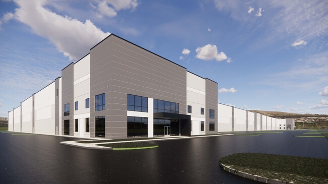
This Property Is For Sale
Current Lease Availabilities
NEARBY LISTINGS FOR SALE OR LEASE
Property Detail
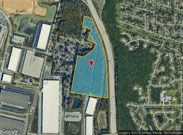
Shadeswood Ave
Louisville-Jefferson County, KY-IN
Minor Plat 8201 Minor Lane
065001420000
TRACT 1 MINOR PLAT PB. 55, PG. 55-56, 64.9739 AC +/-
Industrialacreage
Jefferson
AE
Kentucky
21111C0093F
64.97 AC
2024
South Central
2024
Louisville
001000
DEMOGRAPHICS near Shadeswood Ave
1 Mile
3 Mile
5 Mile
2024 Total Population
5,428
47,696
149,528
2029 Population
5,306
47,478
148,742
Pop Growth 2024-2029
(2.25%)
(0.46%)
(0.53%)
Average Age
35
39
39
2024 Total Households
2,011
19,036
58,835
HH Growth 2024-2029
(2.44%)
(0.49%)
(0.60%)
Median Household Inc
$44,908
$53,885
$56,683
Avg Household Size
2.70
2.40
2.50
2024 Avg HH Vehicles
2.00
2.00
2.00
Median Home Value
$121,662
$155,421
$164,166
Median Year Built
1977
1973
1972
Nearby Places
- Restaurants
- Banks
- Shops
- Fitness
- Groceries
PUBLIC TRANSPORTATION
AIRPORT
Louisville Muhammad Ali International
DRIVE
WALK
Distance
Louisville Muhammad Ali International
14 min
6.0 mi
Freight Ports
Port of Toledo
DRIVE
WALK
Distance
Port of Toledo
369 min
313.6 mi
Nearby Properties
Address
Land Use
TOTAL SIZE
Lot Size
Zoning
Address
Land Use
TOTAL SIZE
Lot Size
Zoning
226,400 SF
150.18 AC
EZ1-ENTERP
Address
Land Use
TOTAL SIZE
Lot Size
Zoning
109.84 AC
R5-RESIDEN
Address
Land Use
TOTAL SIZE
Lot Size
Zoning
257,385 SF
176.30 AC
Address
Land Use
TOTAL SIZE
Lot Size
Zoning
61.37 AC
C2-COMMERC
Address
Land Use
TOTAL SIZE
Lot Size
Zoning
15 AC
C2-COMMERC
Address
Land Use
TOTAL SIZE
Lot Size
Zoning
221,115 SF
97.92 AC
EZ1-ENTERP
Address
Land Use
TOTAL SIZE
Lot Size
Zoning
34.73 AC
Address
Land Use
TOTAL SIZE
Lot Size
Zoning
Address
Land Use
TOTAL SIZE
Lot Size
Zoning
22.14 AC
EZ1-ENTERP
Address
Land Use
TOTAL SIZE
Lot Size
Zoning
822,500 SF
44.75 AC
EZ1-ENTERP
Address
Land Use
TOTAL SIZE
Lot Size
Zoning
39.61 AC
Address
Land Use
TOTAL SIZE
Lot Size
Zoning
407,840 SF
25.51 AC
C2-COMMERC
Address
Land Use
TOTAL SIZE
Lot Size
Zoning
35 AC
C2-COMMERC
Address
Land Use
TOTAL SIZE
Lot Size
Zoning
22.40 AC
Address
Land Use
TOTAL SIZE
Lot Size
Zoning
679,250 SF
35.34 AC
Address
Land Use
TOTAL SIZE
Lot Size
Zoning
102,600 SF
173.89 AC
EZ1-ENTERP
Address
Land Use
TOTAL SIZE
Lot Size
Zoning
13.68 AC
Address
Land Use
TOTAL SIZE
Lot Size
Zoning
321,501 SF
20 AC
M3-INDUSTR
Address
Land Use
TOTAL SIZE
Lot Size
Zoning
14,166 SF
16.32 AC
C1-COMMERC
Address
Land Use
TOTAL SIZE
Lot Size
Zoning
1,484 SF
17.11 AC
R4-RESIDEN
Address
Land Use
TOTAL SIZE
Lot Size
Zoning
4,745 SF
17.95 AC
Address
Land Use
TOTAL SIZE
Lot Size
Zoning
500,000 SF
33.27 AC
PEC-PLANNE
Address
Land Use
TOTAL SIZE
Lot Size
Zoning
1,411 SF
7.65 AC
OR1-OFFICE
Address
Land Use
TOTAL SIZE
Lot Size
Zoning
27.92 AC
EZ1-ENTERP
Address
Land Use
TOTAL SIZE
Lot Size
Zoning
500,000 SF
27.89 AC
Address
Land Use
TOTAL SIZE
Lot Size
Zoning
9.44 AC
R5-RESIDEN
Address
Land Use
TOTAL SIZE
Lot Size
Zoning
636,716 SF
33.71 AC
Address
Land Use
TOTAL SIZE
Lot Size
Zoning
17.17 AC
EZ1-ENTERP
Address
Land Use
TOTAL SIZE
Lot Size
Zoning
517,000 SF
31.95 AC
EZ1-ENTERP
Address
Land Use
TOTAL SIZE
Lot Size
Zoning
402,560 SF
23.70 AC
PEC-PLANNE
The World's #1 Commercial Real Estate Marketplace
Connect with us
© 2025 CoStar Group
The information above has been obtained from sources believed reliable. While we do not doubt its accuracy we have not verified it and make no guarantee, warranty or representation about it. It is your responsibility to independently confirm its accuracy and completeness. Any projections, opinions, assumptions, or estimates used are for example only and do not represent the current or future performance of the property. The value of this transaction to you depends on tax and other factors which should be evaluated by your tax, financial, and legal advisors. You and your advisors should conduct a careful, independent investigation of the property to determine to your satisfaction the suitability of the property for your needs.