Property Record
Shannon Dr, Papillion, NE 68133
NEARBY LISTINGS FOR SALE OR LEASE
Property Detail
Shannon Dr
Omaha-Council Bluffs, NE-IA
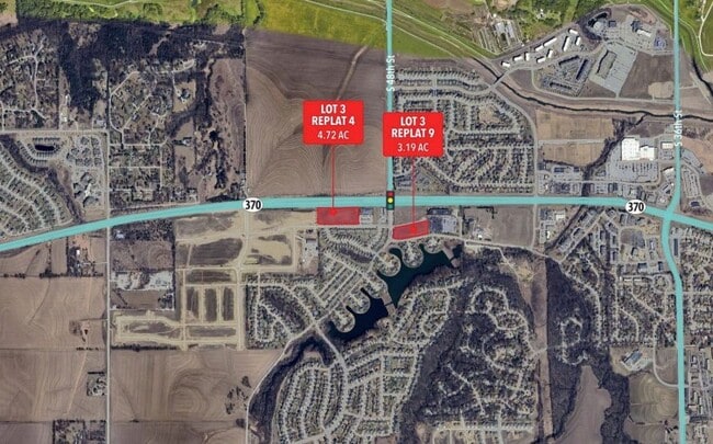
Lakewood Villages
011579701
LOT 3 LAKEWOOD VILLAGES REPLAT 9 (3.19 AC)
Commercialnec
Sarpy
X
Nebraska
31153C0090H
3
2024
4.72 AC
2025
Southeast Omaha
010203
Omaha/Council Bluffs
DEMOGRAPHICS near Shannon Dr
1 Mile
3 Mile
5 Mile
2024 Total Population
6,035
56,986
155,645
2029 Population
6,580
61,575
165,891
Pop Growth 2024-2029
+ 9.03%
+ 8.05%
+ 6.58%
Average Age
40
37
37
2024 Total Households
2,278
20,952
57,143
HH Growth 2024-2029
+ 9.22%
+ 8.20%
+ 6.83%
Median Household Inc
$105,172
$89,348
$75,294
Avg Household Size
2.60
2.70
2.60
2024 Avg HH Vehicles
2.00
2.00
2.00
Median Home Value
$335,571
$266,509
$230,893
Median Year Built
2004
1996
1984
Nearby Places
- Restaurants
- Banks
- Shops
- Fitness
- Groceries
PUBLIC TRANSPORTATION
AIRPORT
Eppley Airfield
DRIVE
WALK
Distance
Eppley Airfield
26 min
16.5 mi
Freight Ports
Tulsa Port Of Catoosa
DRIVE
WALK
Distance
Tulsa Port Of Catoosa
456 min
412.5 mi
SALE & LEASE HISTORY
LISTING DATE
SALE/LEASE

Sep 28, 2018
For Sale
Sep 24, 2016
For Sale
Oct 26, 2019
For Sale
Oct 14, 2020
For Sale
Jun 28, 2023
For Sale
Nearby Properties
Address
Land Use
TOTAL SIZE
Lot Size
Zoning
Address
Land Use
TOTAL SIZE
Lot Size
Zoning
483,925 SF
42.06 AC
Address
Land Use
TOTAL SIZE
Lot Size
Zoning
272,760 SF
2.40 AC
Address
Land Use
TOTAL SIZE
Lot Size
Zoning
28,401 SF
27.31 AC
Address
Land Use
TOTAL SIZE
Lot Size
Zoning
25,204 SF
2.34 AC
R4
Address
Land Use
TOTAL SIZE
Lot Size
Zoning
276,509 SF
3.67 AC
Address
Land Use
TOTAL SIZE
Lot Size
Zoning
17,155 SF
13.11 AC
Address
Land Use
TOTAL SIZE
Lot Size
Zoning
24,969 SF
3.79 AC
RG20
Address
Land Use
TOTAL SIZE
Lot Size
Zoning
10,052 SF
9.38 AC
Address
Land Use
TOTAL SIZE
Lot Size
Zoning
3,906 SF
13.62 AC
RG20
Address
Land Use
TOTAL SIZE
Lot Size
Zoning
18,727 SF
11.15 AC
RG20
Address
Land Use
TOTAL SIZE
Lot Size
Zoning
143 SF
17.56 AC
RG28
Address
Land Use
TOTAL SIZE
Lot Size
Zoning
88,545 SF
9.58 AC
Address
Land Use
TOTAL SIZE
Lot Size
Zoning
1,216 SF
22.82 AC
Address
Land Use
TOTAL SIZE
Lot Size
Zoning
37,196 SF
13.96 AC
MU
Address
Land Use
TOTAL SIZE
Lot Size
Zoning
18,484 SF
5.47 AC
Address
Land Use
TOTAL SIZE
Lot Size
Zoning
117,829 SF
11.13 AC
BG
Address
Land Use
TOTAL SIZE
Lot Size
Zoning
11,244 SF
6.91 AC
Address
Land Use
TOTAL SIZE
Lot Size
Zoning
226,320 SF
12.75 AC
Address
Land Use
TOTAL SIZE
Lot Size
Zoning
217,511 SF
25.06 AC
Address
Land Use
TOTAL SIZE
Lot Size
Zoning
11,889 SF
5.58 AC
Address
Land Use
TOTAL SIZE
Lot Size
Zoning
196,746 SF
10.22 AC
Address
Land Use
TOTAL SIZE
Lot Size
Zoning
3.95 AC
Address
Land Use
TOTAL SIZE
Lot Size
Zoning
400 SF
23.26 AC
Address
Land Use
TOTAL SIZE
Lot Size
Zoning
42,900 SF
16.25 AC
Address
Land Use
TOTAL SIZE
Lot Size
Zoning
92,567 SF
2.43 AC
Address
Land Use
TOTAL SIZE
Lot Size
Zoning
34,104 SF
6.55 AC
Address
Land Use
TOTAL SIZE
Lot Size
Zoning
62,735 SF
0.65 AC
Address
Land Use
TOTAL SIZE
Lot Size
Zoning
87,718 SF
7.92 AC
Address
Land Use
TOTAL SIZE
Lot Size
Zoning
88,232 SF
6.72 AC
BG
The World's #1 Commercial Real Estate Marketplace
Connect with us
© 2025 CoStar Group
The information above has been obtained from sources believed reliable. While we do not doubt its accuracy we have not verified it and make no guarantee, warranty or representation about it. It is your responsibility to independently confirm its accuracy and completeness. Any projections, opinions, assumptions, or estimates used are for example only and do not represent the current or future performance of the property. The value of this transaction to you depends on tax and other factors which should be evaluated by your tax, financial, and legal advisors. You and your advisors should conduct a careful, independent investigation of the property to determine to your satisfaction the suitability of the property for your needs.