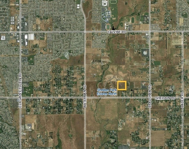
Property Record
Sheldon Rd, Elk Grove, CA 95624

Property Detail
Sheldon Rd
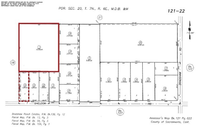
121-0220-001
THE N 12 AC OF THE W 1/2 OF THE SW 1/4 OF THE SE1/4 OF SEC 20, TWP 7 N RGE 6 E EMDB&M
Recreationalacreage
SACRAMENTO
AR-2
California
B and X Area of moderate flood hazard, usually the area between the limits of the 100-year and 500-year floods.
12 AC
2024
South Sacramento
2025
Sacramento
009307
Sacramento-Roseville-Folsom, CA
NEARBY LISTINGS FOR SALE OR LEASE
DEMOGRAPHICS near Sheldon Rd
1 mile
3 mile
5 mile
2025 Total Population
2,090
89,911
204,031
2030 Population
2,053
91,067
207,150
Pop Growth 2025-2030
(1.77%)
+ 1.29%
+ 1.53%
Average Age
41
39
39
2025 Total Households
608
26,646
62,500
HH Growth 2025-2030
(1.81%)
+ 1.27%
+ 1.54%
Median Household Inc
$141,948
$118,500
$104,311
Avg Household Size
3.30
3.30
3.20
2025 Avg HH Vehicles
3.00
2.00
2.00
Median Home Value
$753,238
$672,586
$610,479
Median Year Built
1992
1997
1996
Nearby Places
Map Layers
Map Styles
 Street
 Aerial
Layers
 Traffic
 Biking
Places
Listings with unknown addresses are not visible on the map
- Restaurants
- Banks
- Shops
- Fitness
- Groceries
PUBLIC TRANSPORTATION
AIRPORT
Sacramento International
Drive
Walk
Distance
Sacramento International
39 min
26.8 mi
Freight Ports
Port of Stockton
Drive
Walk
Distance
Port of Stockton
55 min
41.7 mi
SALE & LEASE HISTORY
LISTING DATE
SALE/LEASE

Mar 13, 2018
For Sale
Nearby Properties
Address
Land Use
TOTAL SIZE
Lot Size
Zoning
Address
Land Use
TOTAL SIZE
Lot Size
Zoning
147,920 SF
18.20 AC
SC
Address
Land Use
TOTAL SIZE
Lot Size
Zoning
204,290 SF
11.86 AC
RD-20
Address
Land Use
TOTAL SIZE
Lot Size
Zoning
167,152 SF
7.53 AC
RD-20
Address
Land Use
TOTAL SIZE
Lot Size
Zoning
102,565 SF
4.38 AC
RD-25
Address
Land Use
TOTAL SIZE
Lot Size
Zoning
90,925 SF
9.77 AC
AR-1
Address
Land Use
TOTAL SIZE
Lot Size
Zoning
89,909 SF
8.26 AC
SC
Address
Land Use
TOTAL SIZE
Lot Size
Zoning
45,413 SF
7.31 AC
SC
Address
Land Use
TOTAL SIZE
Lot Size
Zoning
136,225 SF
5.86 AC
RD-20
Address
Land Use
TOTAL SIZE
Lot Size
Zoning
1.99 AC
GC
Address
Land Use
TOTAL SIZE
Lot Size
Zoning
112,007 SF
5.02 AC
RD-20
Address
Land Use
TOTAL SIZE
Lot Size
Zoning
1,595 SF
4.01 AC
RD-25
Address
Land Use
TOTAL SIZE
Lot Size
Zoning
104,812 SF
6.13 AC
SPAEGF
Address
Land Use
TOTAL SIZE
Lot Size
Zoning
54,977 SF
3.94 AC
LI
Address
Land Use
TOTAL SIZE
Lot Size
Zoning
25,783 SF
3.80 AC
GC
Address
Land Use
TOTAL SIZE
Lot Size
Zoning
62,963 SF
4.94 AC
LC
Address
Land Use
TOTAL SIZE
Lot Size
Zoning
55,143 SF
4.46 AC
SC
Address
Land Use
TOTAL SIZE
Lot Size
Zoning
44,668 SF
4.24 AC
SC
Address
Land Use
TOTAL SIZE
Lot Size
Zoning
108,941 SF
4.31 AC
RD-20
Address
Land Use
TOTAL SIZE
Lot Size
Zoning
49,900 SF
6.16 AC
RD-20
Address
Land Use
TOTAL SIZE
Lot Size
Zoning
88,110 SF
5.11 AC
MP
Address
Land Use
TOTAL SIZE
Lot Size
Zoning
11.09 AC
RD-5
Address
Land Use
TOTAL SIZE
Lot Size
Zoning
45,649 SF
4.20 AC
GC
Address
Land Use
TOTAL SIZE
Lot Size
Zoning
25,590 SF
2.37 AC
LC
Address
Land Use
TOTAL SIZE
Lot Size
Zoning
62,001 SF
6 AC
SC
Address
Land Use
TOTAL SIZE
Lot Size
Zoning
82,530 SF
3.56 AC
MP
Address
Land Use
TOTAL SIZE
Lot Size
Zoning
RD-5 O RD-
Address
Land Use
TOTAL SIZE
Lot Size
Zoning
22.42 AC
RD-5
Address
Land Use
TOTAL SIZE
Lot Size
Zoning
56,435 SF
4.89 AC
GC
Address
Land Use
TOTAL SIZE
Lot Size
Zoning
7.13 AC
SC
Address
Land Use
TOTAL SIZE
Lot Size
Zoning
36,500 SF
3.41 AC
SC
The World's #1 Commercial Real Estate Marketplace
Connect with us
© 2026 CoStar Group
The information above has been obtained from sources believed reliable. While we do not doubt its accuracy we have not verified it and make no guarantee, warranty or representation about it. It is your responsibility to independently confirm its accuracy and completeness. Any projections, opinions, assumptions, or estimates used are for example only and do not represent the current or future performance of the property. The value of this transaction to you depends on tax and other factors which should be evaluated by your tax, financial, and legal advisors. You and your advisors should conduct a careful, independent investigation of the property to determine to your satisfaction the suitability of the property for your needs.