Property Record
Sheldon Rd, Hamburg, NY 14075
Save to a Folder
{{folder.Name}}
{{folder.ListingIds.length}} Properties
{{folder.ListingIds.length}} Property
Create a New Folder
Property Detail
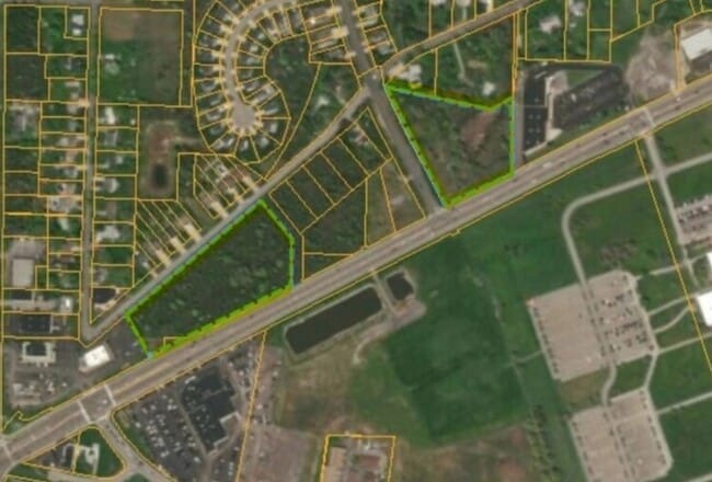
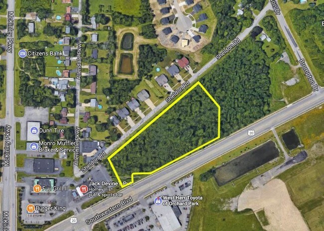
Sheldon Rd
Buffalo-Cheektowaga, NY
SPLIT 1996
144889 160.15-2-2.11
ERIE
Commercialacreage
New York
B and X Area of moderate flood hazard, usually the area between the limits of the 100-year and 500-year floods.
39.200
2025
5.97 AC
2025
South
013400
Buffalo/Niagara Falls
NEARBY LISTINGS FOR SALE OR LEASE
DEMOGRAPHICS near Sheldon Rd
1 mile
3 mile
5 mile
2025 Total Population
4,321
45,652
126,165
2030 Population
4,308
45,884
126,439
Pop Growth 2025-2030
(0.30%)
+ 0.51%
+ 0.22%
Average Age
43
45
43
2025 Total Households
1,873
20,527
54,050
HH Growth 2025-2030
(0.32%)
+ 0.44%
+ 0.15%
Median Household Inc
$74,032
$72,558
$79,312
Avg Household Size
2.20
2.10
2.30
2025 Avg HH Vehicles
2.00
2.00
2.00
Median Home Value
$269,597
$235,438
$253,327
Median Year Built
1975
1972
1964
Nearby Places
Map Layers
Map Styles
 Street
 Aerial
Layers
 Traffic
 Biking
Places
Listings with unknown addresses are not visible on the map
- Restaurants
- Banks
- Shops
- Fitness
- Groceries
PUBLIC TRANSPORTATION
AIRPORT
Buffalo Niagara International
Drive
Walk
Distance
Buffalo Niagara International
29 min
20.0 mi
Niagara Falls International
Drive
Walk
Distance
Niagara Falls International
48 min
31.4 mi
Freight Ports
Port of Toledo
Drive
Walk
Distance
Port of Toledo
343 min
292.5 mi
SALE & LEASE HISTORY
LISTING DATE
SALE/LEASE

Sep 24, 2016
For Sale
Aug 25, 2017
For Sale
Nearby Properties
Address
Land Use
TOTAL SIZE
Lot Size
Zoning
Address
Land Use
TOTAL SIZE
Lot Size
Zoning
14,835 SF
215.22 AC
C2
Address
Land Use
TOTAL SIZE
Lot Size
Zoning
184,188 SF
110.75 AC
Address
Land Use
TOTAL SIZE
Lot Size
Zoning
77,270 SF
46.15 AC
C3
Address
Land Use
TOTAL SIZE
Lot Size
Zoning
118,358 SF
59.67 AC
Address
Land Use
TOTAL SIZE
Lot Size
Zoning
218,461 SF
27.59 AC
C2
Address
Land Use
TOTAL SIZE
Lot Size
Zoning
34,888 SF
29 AC
C1
Address
Land Use
TOTAL SIZE
Lot Size
Zoning
91,618 SF
11.30 AC
Address
Land Use
TOTAL SIZE
Lot Size
Zoning
157,973 SF
16.50 AC
Address
Land Use
TOTAL SIZE
Lot Size
Zoning
10,486 SF
25.30 AC
R3
Address
Land Use
TOTAL SIZE
Lot Size
Zoning
86.94 AC
R4
Address
Land Use
TOTAL SIZE
Lot Size
Zoning
221,896 SF
21.50 AC
Address
Land Use
TOTAL SIZE
Lot Size
Zoning
33,296 SF
12.50 AC
C1
Address
Land Use
TOTAL SIZE
Lot Size
Zoning
7,680 SF
14.20 AC
R3
Address
Land Use
TOTAL SIZE
Lot Size
Zoning
137,276 SF
5.10 AC
Address
Land Use
TOTAL SIZE
Lot Size
Zoning
181,500 SF
58 AC
M3P
Address
Land Use
TOTAL SIZE
Lot Size
Zoning
2,462 SF
11.19 AC
R3
Address
Land Use
TOTAL SIZE
Lot Size
Zoning
127,582 SF
77.30 AC
Address
Land Use
TOTAL SIZE
Lot Size
Zoning
7,448 SF
24.51 AC
R3
Address
Land Use
TOTAL SIZE
Lot Size
Zoning
6,768 SF
13.89 AC
R3
Address
Land Use
TOTAL SIZE
Lot Size
Zoning
7,448 SF
12.16 AC
Address
Land Use
TOTAL SIZE
Lot Size
Zoning
74,669 SF
9.23 AC
Address
Land Use
TOTAL SIZE
Lot Size
Zoning
62,338 SF
10.27 AC
C1
Address
Land Use
TOTAL SIZE
Lot Size
Zoning
136,770 SF
15.20 AC
Address
Land Use
TOTAL SIZE
Lot Size
Zoning
2,252 SF
7.01 AC
R3
Address
Land Use
TOTAL SIZE
Lot Size
Zoning
139,145 SF
33.24 AC
C1
Address
Land Use
TOTAL SIZE
Lot Size
Zoning
24.50 AC
Address
Land Use
TOTAL SIZE
Lot Size
Zoning
4,664 SF
18.10 AC
R3
Address
Land Use
TOTAL SIZE
Lot Size
Zoning
7,354 SF
10.79 AC
R3
Address
Land Use
TOTAL SIZE
Lot Size
Zoning
62.73 AC
R4
Address
Land Use
TOTAL SIZE
Lot Size
Zoning
8,352 SF
16.89 AC
R3
The World's #1 Commercial Real Estate Marketplace
Connect with us
© 2026 CoStar Group
The information above has been obtained from sources believed reliable. While we do not doubt its accuracy we have not verified it and make no guarantee, warranty or representation about it. It is your responsibility to independently confirm its accuracy and completeness. Any projections, opinions, assumptions, or estimates used are for example only and do not represent the current or future performance of the property. The value of this transaction to you depends on tax and other factors which should be evaluated by your tax, financial, and legal advisors. You and your advisors should conduct a careful, independent investigation of the property to determine to your satisfaction the suitability of the property for your needs.