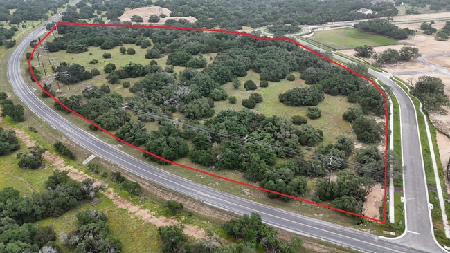
Property Record
Shell Rd, Georgetown, TX 78628
Property Detail
Shell Rd
Austin-Round Rock-San Marcos, TX
AW0524 AW0524 - ROBERTS, WM. SUR., ACRES 7.163
R319283
WILLIAMSON
Vacantlandnec
Texas
B and X Area of moderate flood hazard, usually the area between the limits of the 100-year and 500-year floods.
7.16 AC
2024
Georgetown
2025
Austin
020121
NEARBY LISTINGS FOR SALE OR LEASE
DEMOGRAPHICS near Shell Rd
1 mile
3 mile
5 mile
2024 Total Population
6,698
39,181
69,934
2029 Population
8,168
49,010
88,661
Pop Growth 2024-2029
+ 21.95%
+ 25.09%
+ 26.78%
Average Age
52
55
50
2024 Total Households
3,041
18,269
30,883
HH Growth 2024-2029
+ 22.66%
+ 25.44%
+ 27.30%
Median Household Inc
$102,393
$89,947
$89,956
Avg Household Size
2.20
2.10
2.20
2024 Avg HH Vehicles
2.00
2.00
2.00
Median Home Value
$390,400
$425,591
$437,136
Median Year Built
2006
2005
2006
Nearby Places
Map Layers
Map Styles
 Street
 Aerial
Transit
 Traffic
 Biking
Places
Listings with unknown addresses are not visible on the map
- Restaurants
- Banks
- Shops
- Fitness
- Groceries
PUBLIC TRANSPORTATION
AIRPORT
Killeen Municipal
Drive
Walk
Distance
Killeen Municipal
49 min
37.0 mi
Robert Gray AAF
Drive
Walk
Distance
Robert Gray AAF
53 min
37.9 mi
Freight Ports
Calhoun Port
Drive
Walk
Distance
Calhoun Port
219 min
191.8 mi
SALE & LEASE HISTORY
LISTING DATE
SALE/LEASE

Jun 12, 2024
For Sale
Nearby Properties
Address
Land Use
TOTAL SIZE
Lot Size
Zoning
Address
Land Use
TOTAL SIZE
Lot Size
Zoning
389,888 SF
30 AC
1-MF
Address
Land Use
TOTAL SIZE
Lot Size
Zoning
200,200 SF
34.02 AC
Address
Land Use
TOTAL SIZE
Lot Size
Zoning
310,849 SF
13.15 AC
Address
Land Use
TOTAL SIZE
Lot Size
Zoning
326,646 SF
19.33 AC
Address
Land Use
TOTAL SIZE
Lot Size
Zoning
425,144 SF
32.97 AC
Address
Land Use
TOTAL SIZE
Lot Size
Zoning
439,044 SF
32.68 AC
Address
Land Use
TOTAL SIZE
Lot Size
Zoning
233,173 SF
9.89 AC
Address
Land Use
TOTAL SIZE
Lot Size
Zoning
120,653 SF
12.83 AC
Address
Land Use
TOTAL SIZE
Lot Size
Zoning
241,857 SF
26.60 AC
Address
Land Use
TOTAL SIZE
Lot Size
Zoning
200,746 SF
17.52 AC
Address
Land Use
TOTAL SIZE
Lot Size
Zoning
592 SF
42.32 AC
Address
Land Use
TOTAL SIZE
Lot Size
Zoning
154,603 SF
20.04 AC
Address
Land Use
TOTAL SIZE
Lot Size
Zoning
172,657 SF
8.84 AC
Address
Land Use
TOTAL SIZE
Lot Size
Zoning
174,955 SF
9.28 AC
Address
Land Use
TOTAL SIZE
Lot Size
Zoning
90,821 SF
41.97 AC
Address
Land Use
TOTAL SIZE
Lot Size
Zoning
88,851 SF
11.06 AC
Address
Land Use
TOTAL SIZE
Lot Size
Zoning
176,065 SF
19.48 AC
Address
Land Use
TOTAL SIZE
Lot Size
Zoning
160,042 SF
10.15 AC
Address
Land Use
TOTAL SIZE
Lot Size
Zoning
129,281 SF
17.68 AC
Address
Land Use
TOTAL SIZE
Lot Size
Zoning
123,984 SF
6.89 AC
Address
Land Use
TOTAL SIZE
Lot Size
Zoning
50,543 SF
10.49 AC
Address
Land Use
TOTAL SIZE
Lot Size
Zoning
209,508 SF
13.25 AC
Address
Land Use
TOTAL SIZE
Lot Size
Zoning
188,408 SF
9.62 AC
Address
Land Use
TOTAL SIZE
Lot Size
Zoning
192.21 AC
Address
Land Use
TOTAL SIZE
Lot Size
Zoning
219,839 SF
24.74 AC
Address
Land Use
TOTAL SIZE
Lot Size
Zoning
130,935 SF
7.79 AC
Address
Land Use
TOTAL SIZE
Lot Size
Zoning
98,769 SF
10.76 AC
Address
Land Use
TOTAL SIZE
Lot Size
Zoning
98,769 SF
10.76 AC
Address
Land Use
TOTAL SIZE
Lot Size
Zoning
64,811 SF
8.24 AC
Address
Land Use
TOTAL SIZE
Lot Size
Zoning
150,808 SF
7.72 AC
2-I
The World's #1 Commercial Real Estate Marketplace
Connect with us
© 2026 CoStar Group
The information above has been obtained from sources believed reliable. While we do not doubt its accuracy we have not verified it and make no guarantee, warranty or representation about it. It is your responsibility to independently confirm its accuracy and completeness. Any projections, opinions, assumptions, or estimates used are for example only and do not represent the current or future performance of the property. The value of this transaction to you depends on tax and other factors which should be evaluated by your tax, financial, and legal advisors. You and your advisors should conduct a careful, independent investigation of the property to determine to your satisfaction the suitability of the property for your needs.