Property Record
Shores Ave, Arcadia, FL 34266
NEARBY LISTINGS FOR SALE OR LEASE
Property Detail
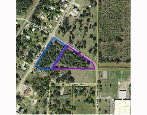
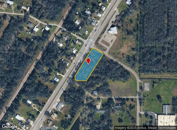
Shores Ave
Arcadia, FL
Town Of Nocatee Rr Survey
23-38-24-0242-0440-0010
TOWN OF NOCATEE RR SURVEY BLK 44 N OF LAND LINE LESS SELY 90 FT LESS & EXCEPT COMM AT NE COR OF SW1/4 OF SEC 23-38-24 TH ALG N LI OF SW 1/4 N 89D37M21S W A DIST OF 93.02 FT TH S 32D28M18S W A DIST OF 1051.32 FT TH S 57D22M14S E A DIST OF 30.00 FT TO
Vacantlandnec
DeSoto
X
Florida
12027C0169C
1.47 AC
2024
Florida Central South Area
2024
Other Market Areas
010302
DEMOGRAPHICS near Shores Ave
1 Mile
3 Mile
5 Mile
2024 Total Population
655
3,726
19,144
2029 Population
725
4,142
21,148
Pop Growth 2024-2029
+ 10.69%
+ 11.16%
+ 10.47%
Average Age
40
38
38
2024 Total Households
227
1,255
6,379
HH Growth 2024-2029
+ 11.89%
+ 12.03%
+ 11.57%
Median Household Inc
$45,961
$43,781
$35,049
Avg Household Size
2.70
2.90
2.80
2024 Avg HH Vehicles
2.00
2.00
2.00
Median Home Value
$201,754
$130,058
$123,586
Median Year Built
1990
1987
1982
Nearby Places
Map Layers
Map Styles
 Street
 Aerial
- Restaurants
- Banks
- Shops
- Fitness
- Groceries
PUBLIC TRANSPORTATION
AIRPORT
Punta Gorda
DRIVE
WALK
Distance
Punta Gorda
29 min
20.8 mi
Freight Ports
Port Manatee
DRIVE
WALK
Distance
Port Manatee
87 min
62.4 mi
Nearby Properties
Address
Land Use
TOTAL SIZE
Lot Size
Zoning
Address
Land Use
TOTAL SIZE
Lot Size
Zoning
67,387 SF
46.10 AC
PUD
Address
Land Use
TOTAL SIZE
Lot Size
Zoning
57,048 SF
20.25 AC
PUD
Address
Land Use
TOTAL SIZE
Lot Size
Zoning
83,273 SF
13.94 AC
ROI
Address
Land Use
TOTAL SIZE
Lot Size
Zoning
21,108 SF
3.36 AC
A-5
Address
Land Use
TOTAL SIZE
Lot Size
Zoning
20,008 SF
4.69 AC
A-5
Address
Land Use
TOTAL SIZE
Lot Size
Zoning
7,514 SF
121.57 AC
A-5
Address
Land Use
TOTAL SIZE
Lot Size
Zoning
10,972 SF
6.77 AC
RSF-3
Address
Land Use
TOTAL SIZE
Lot Size
Zoning
50,951 SF
47.23 AC
IH
Address
Land Use
TOTAL SIZE
Lot Size
Zoning
47,950 SF
5.66 AC
IL
Address
Land Use
TOTAL SIZE
Lot Size
Zoning
96 SF
95.92 AC
A-10
Address
Land Use
TOTAL SIZE
Lot Size
Zoning
8,763 SF
5.31 AC
A-10
Address
Land Use
TOTAL SIZE
Lot Size
Zoning
7,307 SF
305.60 AC
A-5
Address
Land Use
TOTAL SIZE
Lot Size
Zoning
7,895 SF
2.47 AC
CG
Address
Land Use
TOTAL SIZE
Lot Size
Zoning
4,220 SF
312.23 AC
A-5
Address
Land Use
TOTAL SIZE
Lot Size
Zoning
13,642 SF
124.26 AC
A-5
Address
Land Use
TOTAL SIZE
Lot Size
Zoning
5,696 SF
27.29 AC
A-5
Address
Land Use
TOTAL SIZE
Lot Size
Zoning
4,404 SF
37.41 AC
A-5
Address
Land Use
TOTAL SIZE
Lot Size
Zoning
4,968 SF
10.19 AC
IL
Address
Land Use
TOTAL SIZE
Lot Size
Zoning
4,354 SF
54.99 AC
A-10
Address
Land Use
TOTAL SIZE
Lot Size
Zoning
7,555 SF
1.21 AC
RM
Address
Land Use
TOTAL SIZE
Lot Size
Zoning
9,230 SF
1.29 AC
CG
Address
Land Use
TOTAL SIZE
Lot Size
Zoning
11,232 SF
2.65 AC
RMF-M
Address
Land Use
TOTAL SIZE
Lot Size
Zoning
5,329 SF
15.27 AC
A-5
Address
Land Use
TOTAL SIZE
Lot Size
Zoning
3,720 SF
148.02 AC
A-5
Address
Land Use
TOTAL SIZE
Lot Size
Zoning
3,842 SF
181.64 AC
A-5
Address
Land Use
TOTAL SIZE
Lot Size
Zoning
6,312 SF
6 AC
ROI
Address
Land Use
TOTAL SIZE
Lot Size
Zoning
14,271 SF
2.50 AC
IL
Address
Land Use
TOTAL SIZE
Lot Size
Zoning
16,420 SF
1.88 AC
CG
Address
Land Use
TOTAL SIZE
Lot Size
Zoning
2,368 SF
10.93 AC
A-5
Address
Land Use
TOTAL SIZE
Lot Size
Zoning
1,620 SF
18.35 AC
A-10
The World's #1 Commercial Real Estate Marketplace
Connect with us
© 2025 CoStar Group
The information above has been obtained from sources believed reliable. While we do not doubt its accuracy we have not verified it and make no guarantee, warranty or representation about it. It is your responsibility to independently confirm its accuracy and completeness. Any projections, opinions, assumptions, or estimates used are for example only and do not represent the current or future performance of the property. The value of this transaction to you depends on tax and other factors which should be evaluated by your tax, financial, and legal advisors. You and your advisors should conduct a careful, independent investigation of the property to determine to your satisfaction the suitability of the property for your needs.