Property Record
Shortman Rd, Ripley, NY 14775
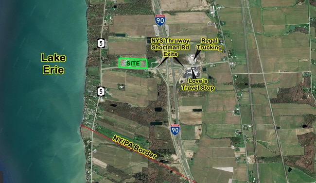
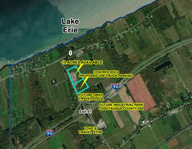
This Property Is For Sale
NEARBY LISTINGS FOR SALE OR LEASE
Property Detail
Shortman Rd
Other Market Areas
OLD APN: 066200 1-1-15
Jamestown-Dunkirk, NY
Chautauqua
066200-240-000-0001-030-000
New York
Commercialacreage
29.000
2025
6 AC
2024
New York West Area
036600
DEMOGRAPHICS near Shortman Rd
1 mile
3 mile
5 mile
2024 Total Population
113
1,630
3,439
2029 Population
110
1,580
3,364
Pop Growth 2024-2029
(2.65%)
(3.07%)
(2.18%)
Average Age
45
44
45
2024 Total Households
49
682
1,450
HH Growth 2024-2029
(4.08%)
(3.08%)
(2.21%)
Median Household Inc
$45,833
$49,422
$58,186
Avg Household Size
2.30
2.30
2.30
2024 Avg HH Vehicles
2.00
2.00
2.00
Median Home Value
$110,714
$110,897
$148,351
Median Year Built
1961
1949
1956
Nearby Places
Map Layers
Map Styles
 Street
 Aerial
Transit
 Traffic
 Biking
Places
Listings with unknown addresses are not visible on the map
- Restaurants
- Banks
- Shops
- Fitness
- Groceries
PUBLIC TRANSPORTATION
AIRPORT
Erie International/Tom Ridge Field
Drive
Walk
Distance
Erie International/Tom Ridge Field
42 min
27.8 mi
Freight Ports
Port of Toledo
Drive
Walk
Distance
Port of Toledo
273 min
232.9 mi
Nearby Properties
Address
Land Use
TOTAL SIZE
Lot Size
Zoning
Address
Land Use
TOTAL SIZE
Lot Size
Zoning
14,115 SF
10.20 AC
C-2
Address
Land Use
TOTAL SIZE
Lot Size
Zoning
6,705 SF
2.26 AC
R2
Address
Land Use
TOTAL SIZE
Lot Size
Zoning
67,630 SF
4.50 AC
01 - NOT Z
Address
Land Use
TOTAL SIZE
Lot Size
Zoning
0.01 AC
Address
Land Use
TOTAL SIZE
Lot Size
Zoning
0.01 AC
Address
Land Use
TOTAL SIZE
Lot Size
Zoning
7,874 SF
28 AC
Address
Land Use
TOTAL SIZE
Lot Size
Zoning
0.75 AC
01 - NOT Z
Address
Land Use
TOTAL SIZE
Lot Size
Zoning
9,100 SF
1.40 AC
01
Address
Land Use
TOTAL SIZE
Lot Size
Zoning
449 SF
0.88 AC
R1
Address
Land Use
TOTAL SIZE
Lot Size
Zoning
0.01 AC
Address
Land Use
TOTAL SIZE
Lot Size
Zoning
2,760 SF
5.30 AC
01 - NOT Z
Address
Land Use
TOTAL SIZE
Lot Size
Zoning
20,325 SF
27.49 AC
I
Address
Land Use
TOTAL SIZE
Lot Size
Zoning
47,251 SF
6.41 AC
I
Address
Land Use
TOTAL SIZE
Lot Size
Zoning
0.01 AC
Address
Land Use
TOTAL SIZE
Lot Size
Zoning
0.01 AC
Address
Land Use
TOTAL SIZE
Lot Size
Zoning
10.51 AC
R2
Address
Land Use
TOTAL SIZE
Lot Size
Zoning
14,652 SF
3.61 AC
I
Address
Land Use
TOTAL SIZE
Lot Size
Zoning
4,000 SF
0.15 AC
01 - NOT Z
Address
Land Use
TOTAL SIZE
Lot Size
Zoning
0.01 AC
Address
Land Use
TOTAL SIZE
Lot Size
Zoning
3,822 SF
3.27 AC
Address
Land Use
TOTAL SIZE
Lot Size
Zoning
0.01 AC
Address
Land Use
TOTAL SIZE
Lot Size
Zoning
7,000 SF
3 AC
RA
Address
Land Use
TOTAL SIZE
Lot Size
Zoning
16,893 SF
9.50 AC
I
Address
Land Use
TOTAL SIZE
Lot Size
Zoning
14,832 SF
2.90 AC
01 - NOT Z
Address
Land Use
TOTAL SIZE
Lot Size
Zoning
0.01 AC
Address
Land Use
TOTAL SIZE
Lot Size
Zoning
3,200 SF
9.20 AC
RA
Address
Land Use
TOTAL SIZE
Lot Size
Zoning
8,390 SF
0.25 AC
01 - NOT Z
Address
Land Use
TOTAL SIZE
Lot Size
Zoning
12,372 SF
18.45 AC
A
Address
Land Use
TOTAL SIZE
Lot Size
Zoning
2,016 SF
18.10 AC
RA
Address
Land Use
TOTAL SIZE
Lot Size
Zoning
9,349 SF
13 AC
RA
The World's #1 Commercial Real Estate Marketplace
Connect with us
© 2026 CoStar Group
The information above has been obtained from sources believed reliable. While we do not doubt its accuracy we have not verified it and make no guarantee, warranty or representation about it. It is your responsibility to independently confirm its accuracy and completeness. Any projections, opinions, assumptions, or estimates used are for example only and do not represent the current or future performance of the property. The value of this transaction to you depends on tax and other factors which should be evaluated by your tax, financial, and legal advisors. You and your advisors should conduct a careful, independent investigation of the property to determine to your satisfaction the suitability of the property for your needs.