Property Record
5870 White Eagle Blvd, Bradenton, FL 34211
This Property Is For Sale
Current Lease Availabilities
NEARBY LISTINGS FOR SALE OR LEASE
Property Detail
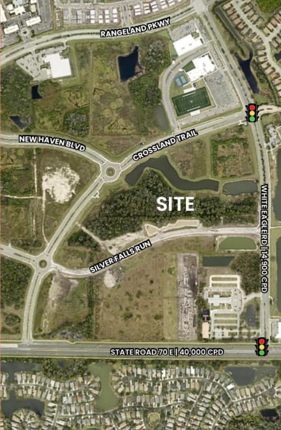
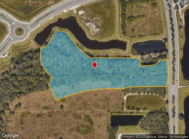
5870 White Eagle Blvd
North Port-Sarasota-Bradenton, FL
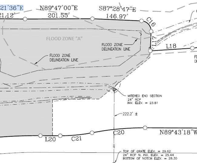
A TRACT OF LAND LYING IN SECS 16 & 17, TWN 35S, RNG 19E, MANATEE COUNTY, FLORIDA, BEING MORE PARTICULARLY DESC AS FOLLOWS: COM AT THE SE COR OF CROSSLAND TRAIL AS DESC IN SW
5832-0860-9
Manatee
Vacantlandnec
Florida
0
13.20 AC
2025
Manatee Outlying
002019
Tampa/St Petersburg
DEMOGRAPHICS near 5870 White Eagle Blvd
1 Mile
3 Mile
5 Mile
2024 Total Population
7,996
42,013
91,067
2029 Population
9,049
47,529
102,668
Pop Growth 2024-2029
+ 13.17%
+ 13.13%
+ 12.74%
Average Age
44
47
49
2024 Total Households
3,284
17,726
39,199
HH Growth 2024-2029
+ 13.55%
+ 13.29%
+ 12.84%
Median Household Inc
$112,408
$122,451
$116,782
Avg Household Size
2.40
2.30
2.30
2024 Avg HH Vehicles
2.00
2.00
2.00
Median Home Value
$638,547
$677,611
$627,949
Median Year Built
2011
2010
2009
Nearby Places
- Restaurants
- Banks
- Shops
- Fitness
- Groceries
PUBLIC TRANSPORTATION
AIRPORT
Sarasota/Bradenton International
DRIVE
WALK
Distance
Sarasota/Bradenton International
26 min
14.7 mi
Freight Ports
Port Manatee
DRIVE
WALK
Distance
Port Manatee
31 min
20.6 mi
Nearby Properties
Address
Land Use
TOTAL SIZE
Lot Size
Zoning
Address
Land Use
TOTAL SIZE
Lot Size
Zoning
602,710 SF
36.57 AC
PD-MU
Address
Land Use
TOTAL SIZE
Lot Size
Zoning
451,049 SF
55.56 AC
PDMU
Address
Land Use
TOTAL SIZE
Lot Size
Zoning
512,380 SF
11.24 AC
PD-MU
Address
Land Use
TOTAL SIZE
Lot Size
Zoning
483,594 SF
23.32 AC
PD-MU
Address
Land Use
TOTAL SIZE
Lot Size
Zoning
409,825 SF
23.98 AC
PD-MU
Address
Land Use
TOTAL SIZE
Lot Size
Zoning
335,712 SF
27.91 AC
PD-MU
Address
Land Use
TOTAL SIZE
Lot Size
Zoning
349,151 SF
16.70 AC
PD-MU
Address
Land Use
TOTAL SIZE
Lot Size
Zoning
384,346 SF
56.41 AC
PD-PI
Address
Land Use
TOTAL SIZE
Lot Size
Zoning
405,307 SF
23.79 AC
PD-MU
Address
Land Use
TOTAL SIZE
Lot Size
Zoning
422,013 SF
11 AC
PD-MU
Address
Land Use
TOTAL SIZE
Lot Size
Zoning
201,213 SF
27.17 AC
PD-MU
Address
Land Use
TOTAL SIZE
Lot Size
Zoning
211,519 SF
82.32 AC
PD-MU
Address
Land Use
TOTAL SIZE
Lot Size
Zoning
303,515 SF
36.98 AC
PD-MU
Address
Land Use
TOTAL SIZE
Lot Size
Zoning
125,972 SF
24.18 AC
PD-PI
Address
Land Use
TOTAL SIZE
Lot Size
Zoning
235,732 SF
49.34 AC
PD-PI
Address
Land Use
TOTAL SIZE
Lot Size
Zoning
175,410 SF
39.05 AC
PD-MU
Address
Land Use
TOTAL SIZE
Lot Size
Zoning
112,961 SF
19.44 AC
Address
Land Use
TOTAL SIZE
Lot Size
Zoning
345,812 SF
37 AC
PD-R
Address
Land Use
TOTAL SIZE
Lot Size
Zoning
227,842 SF
12.97 AC
PD-C
Address
Land Use
TOTAL SIZE
Lot Size
Zoning
180,574 SF
22 AC
A GENERAL
Address
Land Use
TOTAL SIZE
Lot Size
Zoning
75,712 SF
33.55 AC
PD-MU
Address
Land Use
TOTAL SIZE
Lot Size
Zoning
109,010 SF
7 AC
PD-MU
Address
Land Use
TOTAL SIZE
Lot Size
Zoning
125,678 SF
48.86 AC
Address
Land Use
TOTAL SIZE
Lot Size
Zoning
94,206 SF
10.62 AC
PD-C
Address
Land Use
TOTAL SIZE
Lot Size
Zoning
121,771 SF
28.17 AC
A-1 SUBURB
Address
Land Use
TOTAL SIZE
Lot Size
Zoning
180,648 SF
21.97 AC
PD-MU
Address
Land Use
TOTAL SIZE
Lot Size
Zoning
82,573 SF
16.26 AC
PD-C
Address
Land Use
TOTAL SIZE
Lot Size
Zoning
139,763 SF
6.66 AC
PD-MU
Address
Land Use
TOTAL SIZE
Lot Size
Zoning
379.78 AC
Address
Land Use
TOTAL SIZE
Lot Size
Zoning
44,216 SF
74.28 AC
A,PD-R
The World's #1 Commercial Real Estate Marketplace
Connect with us
© 2025 CoStar Group
The information above has been obtained from sources believed reliable. While we do not doubt its accuracy we have not verified it and make no guarantee, warranty or representation about it. It is your responsibility to independently confirm its accuracy and completeness. Any projections, opinions, assumptions, or estimates used are for example only and do not represent the current or future performance of the property. The value of this transaction to you depends on tax and other factors which should be evaluated by your tax, financial, and legal advisors. You and your advisors should conduct a careful, independent investigation of the property to determine to your satisfaction the suitability of the property for your needs.