Property Record
Silver Ridge Apts, Toms River, NJ 08755

Save to a Folder
{{folder.Name}}
{{folder.ListingIds.length}} Properties
{{folder.ListingIds.length}} Property
Create a New Folder
Property Detail
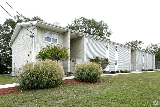
Silver Ridge Apts
08-00538-0000-00022
22.96AC
Apartment
OCEAN
SPLT
New Jersey
AE The base floodplain where base flood elevations are provided. AE Zones are now used on new format FIRMs instead of A1-A30 Zones.
29
2025
31.93 AC
2026
Downtown Toms River
722003
Northern New Jersey
1,029 SF
Lakewood-New Brunswick, NJ
NEARBY LISTINGS FOR SALE OR LEASE
-
-
View all Toms River listings for sale on LoopNet.com
DEMOGRAPHICS near Silver Ridge Apts
1 mile
3 mile
5 mile
2025 Total Population
6,523
57,570
130,322
2030 Population
6,639
58,380
132,556
Pop Growth 2025-2030
+ 1.78%
+ 1.41%
+ 1.71%
Average Age
39
44
44
2025 Total Households
2,552
23,113
50,866
HH Growth 2025-2030
+ 1.21%
+ 0.91%
+ 1.15%
Median Household Inc
$78,656
$79,632
$83,862
Avg Household Size
2.40
2.40
2.40
2025 Avg HH Vehicles
2.00
2.00
2.00
Median Home Value
$317,452
$331,190
$348,429
Median Year Built
1972
1975
1977
Nearby Places
Map Layers
Map Styles
 Street
 Aerial
Layers
 Traffic
 Biking
Places
Listings with unknown addresses are not visible on the map
- Restaurants
- Banks
- Shops
- Fitness
- Groceries
Nearby Properties
Address
Land Use
TOTAL SIZE
Lot Size
Zoning
Address
Land Use
TOTAL SIZE
Lot Size
Zoning
70.33 AC
RC
Address
Land Use
TOTAL SIZE
Lot Size
Zoning
14,748 SF
56.53 AC
MF8
Address
Land Use
TOTAL SIZE
Lot Size
Zoning
38.17 AC
HMS
Address
Land Use
TOTAL SIZE
Lot Size
Zoning
83.07 AC
R400
Address
Land Use
TOTAL SIZE
Lot Size
Zoning
15.67 AC
RC
Address
Land Use
TOTAL SIZE
Lot Size
Zoning
14,136 SF
11.85 AC
VO
Address
Land Use
TOTAL SIZE
Lot Size
Zoning
260 SF
326.26 AC
SPLT
Address
Land Use
TOTAL SIZE
Lot Size
Zoning
165,024 SF
22.43 AC
HB
Address
Land Use
TOTAL SIZE
Lot Size
Zoning
8.21 AC
VO
Address
Land Use
TOTAL SIZE
Lot Size
Zoning
1,414 SF
35.40 AC
RHB
Address
Land Use
TOTAL SIZE
Lot Size
Zoning
1,332 SF
13.76 AC
EM18
Address
Land Use
TOTAL SIZE
Lot Size
Zoning
18,890 SF
24.59 AC
SPLT
Address
Land Use
TOTAL SIZE
Lot Size
Zoning
11,304 SF
25.56 AC
MF8
Address
Land Use
TOTAL SIZE
Lot Size
Zoning
57,008 SF
8.85 AC
SPLT
Address
Land Use
TOTAL SIZE
Lot Size
Zoning
19,836 SF
13.03 AC
EM18
Address
Land Use
TOTAL SIZE
Lot Size
Zoning
90,240 SF
8.66 AC
RHB
Address
Land Use
TOTAL SIZE
Lot Size
Zoning
7,436 SF
22.36 AC
MF8
Address
Land Use
TOTAL SIZE
Lot Size
Zoning
2,176 SF
22.96 AC
MF8
Address
Land Use
TOTAL SIZE
Lot Size
Zoning
15.68 AC
MF8
Address
Land Use
TOTAL SIZE
Lot Size
Zoning
8,512 SF
25.67 AC
RC
Address
Land Use
TOTAL SIZE
Lot Size
Zoning
2,549 SF
16.02 AC
RC
Address
Land Use
TOTAL SIZE
Lot Size
Zoning
26,832 SF
11.09 AC
RC
Address
Land Use
TOTAL SIZE
Lot Size
Zoning
129,411 SF
24.53 AC
RHB
Address
Land Use
TOTAL SIZE
Lot Size
Zoning
4,264 SF
189.71 AC
R400
Address
Land Use
TOTAL SIZE
Lot Size
Zoning
44.86 AC
SPLT
Address
Land Use
TOTAL SIZE
Lot Size
Zoning
6,098 SF
7.66 AC
EM18
Address
Land Use
TOTAL SIZE
Lot Size
Zoning
4,275 SF
5.47 AC
HMS
Address
Land Use
TOTAL SIZE
Lot Size
Zoning
115,528 SF
17.59 AC
SPLT
Address
Land Use
TOTAL SIZE
Lot Size
Zoning
14,432 SF
15.69 AC
RHB
Address
Land Use
TOTAL SIZE
Lot Size
Zoning
8.82 AC
O15
The World's #1 Commercial Real Estate Marketplace
Connect with us
© 2026 CoStar Group
The information above has been obtained from sources believed reliable. While we do not doubt its accuracy we have not verified it and make no guarantee, warranty or representation about it. It is your responsibility to independently confirm its accuracy and completeness. Any projections, opinions, assumptions, or estimates used are for example only and do not represent the current or future performance of the property. The value of this transaction to you depends on tax and other factors which should be evaluated by your tax, financial, and legal advisors. You and your advisors should conduct a careful, independent investigation of the property to determine to your satisfaction the suitability of the property for your needs.