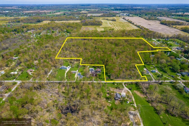
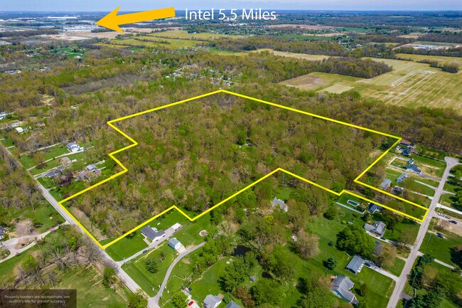
Property Record
Sims Rd, Pataskala, OH 43062
Property Detail
Sims Rd
Columbus, OH
1.33 AC SEC 6 R15 T1 Q2
063-145602-00.000
LICKING
Residentialacreage
Ohio
B and X Area of moderate flood hazard, usually the area between the limits of the 100-year and 500-year floods.
0.70 AC
2024
Licking County
2024
Columbus
755901
NEARBY LISTINGS FOR SALE OR LEASE
DEMOGRAPHICS near Sims Rd
1 mile
3 mile
5 mile
2025 Total Population
1,038
25,783
87,858
2030 Population
1,097
26,555
90,235
Pop Growth 2025-2030
+ 5.68%
+ 2.99%
+ 2.71%
Average Age
42
37
38
2025 Total Households
377
8,730
32,319
HH Growth 2025-2030
+ 5.31%
+ 3.16%
+ 2.78%
Median Household Inc
$120,754
$107,393
$106,310
Avg Household Size
2.70
2.90
2.70
2025 Avg HH Vehicles
2.00
2.00
2.00
Median Home Value
$499,999
$344,429
$354,750
Median Year Built
1997
2003
2000
Nearby Places
Map Layers
Map Styles
 Street
 Aerial
Transit
 Traffic
 Biking
Places
Listings with unknown addresses are not visible on the map
- Restaurants
- Banks
- Shops
- Fitness
- Groceries
PUBLIC TRANSPORTATION
AIRPORT
John Glenn Columbus International
Drive
Walk
Distance
John Glenn Columbus International
19 min
10.1 mi
Rickenbacker International
Drive
Walk
Distance
Rickenbacker International
34 min
21.5 mi
Freight Ports
Port of Toledo
Drive
Walk
Distance
Port of Toledo
191 min
150.7 mi
SALE & LEASE HISTORY
LISTING DATE
SALE/LEASE

May 08, 2024
For Sale
May 08, 2024
For Sale
Nearby Properties
Address
Land Use
TOTAL SIZE
Lot Size
Zoning
Address
Land Use
TOTAL SIZE
Lot Size
Zoning
46,000 SF
214.46 AC
Address
Land Use
TOTAL SIZE
Lot Size
Zoning
624,564 SF
104.45 AC
Address
Land Use
TOTAL SIZE
Lot Size
Zoning
141,988 SF
219.25 AC
Address
Land Use
TOTAL SIZE
Lot Size
Zoning
772,217 SF
98.64 AC
Address
Land Use
TOTAL SIZE
Lot Size
Zoning
811,338 SF
222.09 AC
Address
Land Use
TOTAL SIZE
Lot Size
Zoning
154.52 AC
Address
Land Use
TOTAL SIZE
Lot Size
Zoning
279.62 AC
Address
Land Use
TOTAL SIZE
Lot Size
Zoning
151,476 SF
83.45 AC
Address
Land Use
TOTAL SIZE
Lot Size
Zoning
51,968 SF
22.80 AC
Address
Land Use
TOTAL SIZE
Lot Size
Zoning
1,809 SF
134.92 AC
Address
Land Use
TOTAL SIZE
Lot Size
Zoning
95,576 SF
16 AC
Address
Land Use
TOTAL SIZE
Lot Size
Zoning
29,720 SF
0.23 AC
Address
Land Use
TOTAL SIZE
Lot Size
Zoning
83,892 SF
15.80 AC
Address
Land Use
TOTAL SIZE
Lot Size
Zoning
105,628 SF
17.72 AC
Address
Land Use
TOTAL SIZE
Lot Size
Zoning
143,397 SF
16.78 AC
Address
Land Use
TOTAL SIZE
Lot Size
Zoning
49,325 SF
27.75 AC
Address
Land Use
TOTAL SIZE
Lot Size
Zoning
51,789 SF
68.74 AC
Address
Land Use
TOTAL SIZE
Lot Size
Zoning
7,386 SF
115.74 AC
Address
Land Use
TOTAL SIZE
Lot Size
Zoning
10,419 SF
12.37 AC
Address
Land Use
TOTAL SIZE
Lot Size
Zoning
18,538 SF
78.11 AC
Address
Land Use
TOTAL SIZE
Lot Size
Zoning
26,235 SF
14.45 AC
Address
Land Use
TOTAL SIZE
Lot Size
Zoning
31,208 SF
17.21 AC
Address
Land Use
TOTAL SIZE
Lot Size
Zoning
47,965 SF
10.54 AC
Address
Land Use
TOTAL SIZE
Lot Size
Zoning
4,641 SF
35.13 AC
Address
Land Use
TOTAL SIZE
Lot Size
Zoning
1,058 SF
58.11 AC
Address
Land Use
TOTAL SIZE
Lot Size
Zoning
23.94 AC
Address
Land Use
TOTAL SIZE
Lot Size
Zoning
2,692 SF
23.09 AC
Address
Land Use
TOTAL SIZE
Lot Size
Zoning
25,860 SF
5.69 AC
Address
Land Use
TOTAL SIZE
Lot Size
Zoning
56.62 AC
Address
Land Use
TOTAL SIZE
Lot Size
Zoning
12,117 SF
4.17 AC
The World's #1 Commercial Real Estate Marketplace
Connect with us
© 2026 CoStar Group
The information above has been obtained from sources believed reliable. While we do not doubt its accuracy we have not verified it and make no guarantee, warranty or representation about it. It is your responsibility to independently confirm its accuracy and completeness. Any projections, opinions, assumptions, or estimates used are for example only and do not represent the current or future performance of the property. The value of this transaction to you depends on tax and other factors which should be evaluated by your tax, financial, and legal advisors. You and your advisors should conduct a careful, independent investigation of the property to determine to your satisfaction the suitability of the property for your needs.