Property Record
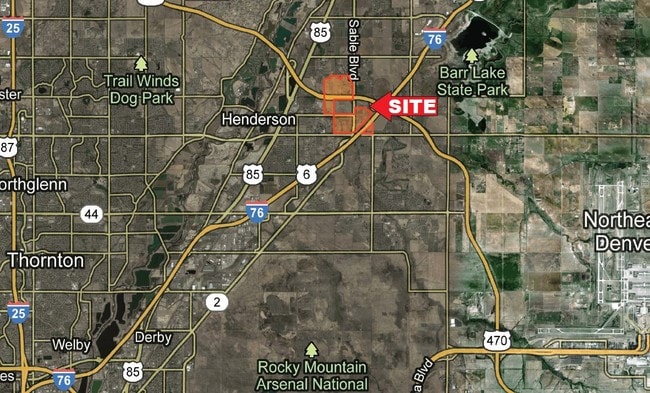
Situs Not Available, Brighton, CO 80602
Property Detail
Situs Not Available
1569-31-4-00-001
SECT,TWN,RNG:31-1-66 DESC: SW4 EXC PARC IN SE COR AND EXC HIWAY 141/525A
Vacantlandnec
ADAMS
A3
Colorado
B and X Area of moderate flood hazard, usually the area between the limits of the 100-year and 500-year floods.
12.61 AC
2024
Northeast Denver
2025
Denver
008552
Denver-Aurora-Centennial, CO
NEARBY LISTINGS FOR SALE OR LEASE
-
-
-
-
-
-
-
No Photo
-
View all Brighton listings for sale on LoopNet.com
DEMOGRAPHICS near Situs Not Available
1 mile
3 mile
5 mile
2025 Total Population
2,603
32,082
90,591
2030 Population
2,745
33,925
95,649
Pop Growth 2025-2030
+ 5.46%
+ 5.74%
+ 5.58%
Average Age
37
35
36
2025 Total Households
839
10,012
29,543
HH Growth 2025-2030
+ 5.84%
+ 6.07%
+ 5.91%
Median Household Inc
$136,764
$139,261
$127,246
Avg Household Size
3.10
3.20
3.00
2025 Avg HH Vehicles
3.00
2.00
2.00
Median Home Value
$598,734
$615,257
$602,152
Median Year Built
2005
2008
2006
Nearby Places
Map Layers
Map Styles
 Street
 Aerial
Transit
 Traffic
 Biking
Places
Listings with unknown addresses are not visible on the map
- Restaurants
- Banks
- Shops
- Fitness
- Groceries
PUBLIC TRANSPORTATION
COMMUTER RAIL
Thornton Crossroads - 104Th Station Track 1 (Union Station to Eastlake & 124th Station - Regional Transportation District)
Drive
Walk
Distance
Thornton Crossroads - 104Th Station Track 1 (Union Station to Eastlake & 124th Station - Regional Transportation District)
14 min
8.7 mi
AIRPORT
Denver International
Drive
Walk
Distance
Denver International
18 min
13.6 mi
Freight Ports
Tulsa Port Of Catoosa
Drive
Walk
Distance
Tulsa Port Of Catoosa
725 min
707.7 mi
SALE & LEASE HISTORY
LISTING DATE
SALE/LEASE

Sep 24, 2016
For Sale
Feb 21, 2018
For Sale
Nearby Properties
Address
Land Use
TOTAL SIZE
Lot Size
Zoning
Address
Land Use
TOTAL SIZE
Lot Size
Zoning
279,946 SF
11.55 AC
Address
Land Use
TOTAL SIZE
Lot Size
Zoning
358,386 SF
76.08 AC
Address
Land Use
TOTAL SIZE
Lot Size
Zoning
121,103 SF
13.47 AC
Address
Land Use
TOTAL SIZE
Lot Size
Zoning
231,205 SF
10.46 AC
Address
Land Use
TOTAL SIZE
Lot Size
Zoning
Address
Land Use
TOTAL SIZE
Lot Size
Zoning
207,682 SF
7.16 AC
Address
Land Use
TOTAL SIZE
Lot Size
Zoning
64,715 SF
10.38 AC
Address
Land Use
TOTAL SIZE
Lot Size
Zoning
70,573 SF
6.42 AC
Address
Land Use
TOTAL SIZE
Lot Size
Zoning
122,399 SF
14.29 AC
Address
Land Use
TOTAL SIZE
Lot Size
Zoning
168,506 SF
21.67 AC
Address
Land Use
TOTAL SIZE
Lot Size
Zoning
55,810 SF
14.52 AC
Address
Land Use
TOTAL SIZE
Lot Size
Zoning
70,573 SF
14.73 AC
Address
Land Use
TOTAL SIZE
Lot Size
Zoning
19,341 SF
74.46 AC
Address
Land Use
TOTAL SIZE
Lot Size
Zoning
75,398 SF
8.82 AC
I2
Address
Land Use
TOTAL SIZE
Lot Size
Zoning
102,069 SF
3.26 AC
Address
Land Use
TOTAL SIZE
Lot Size
Zoning
104,395 SF
10.43 AC
Address
Land Use
TOTAL SIZE
Lot Size
Zoning
42,177 SF
17.73 AC
A3
Address
Land Use
TOTAL SIZE
Lot Size
Zoning
24.65 AC
A3
Address
Land Use
TOTAL SIZE
Lot Size
Zoning
44,077 SF
13.02 AC
Address
Land Use
TOTAL SIZE
Lot Size
Zoning
90,208 SF
7.19 AC
Address
Land Use
TOTAL SIZE
Lot Size
Zoning
61,793 SF
9.28 AC
Address
Land Use
TOTAL SIZE
Lot Size
Zoning
Address
Land Use
TOTAL SIZE
Lot Size
Zoning
24.92 AC
I2
Address
Land Use
TOTAL SIZE
Lot Size
Zoning
12,842 SF
2.17 AC
Address
Land Use
TOTAL SIZE
Lot Size
Zoning
26,010 SF
8.68 AC
Address
Land Use
TOTAL SIZE
Lot Size
Zoning
17,160 SF
2.05 AC
Address
Land Use
TOTAL SIZE
Lot Size
Zoning
30,000 SF
5.79 AC
Address
Land Use
TOTAL SIZE
Lot Size
Zoning
14,569 SF
7.94 AC
I3
Address
Land Use
TOTAL SIZE
Lot Size
Zoning
10,750 SF
7.94 AC
Address
Land Use
TOTAL SIZE
Lot Size
Zoning
25,527 SF
3.63 AC
The World's #1 Commercial Real Estate Marketplace
Connect with us
© 2026 CoStar Group
The information above has been obtained from sources believed reliable. While we do not doubt its accuracy we have not verified it and make no guarantee, warranty or representation about it. It is your responsibility to independently confirm its accuracy and completeness. Any projections, opinions, assumptions, or estimates used are for example only and do not represent the current or future performance of the property. The value of this transaction to you depends on tax and other factors which should be evaluated by your tax, financial, and legal advisors. You and your advisors should conduct a careful, independent investigation of the property to determine to your satisfaction the suitability of the property for your needs.